Cape Agulhas
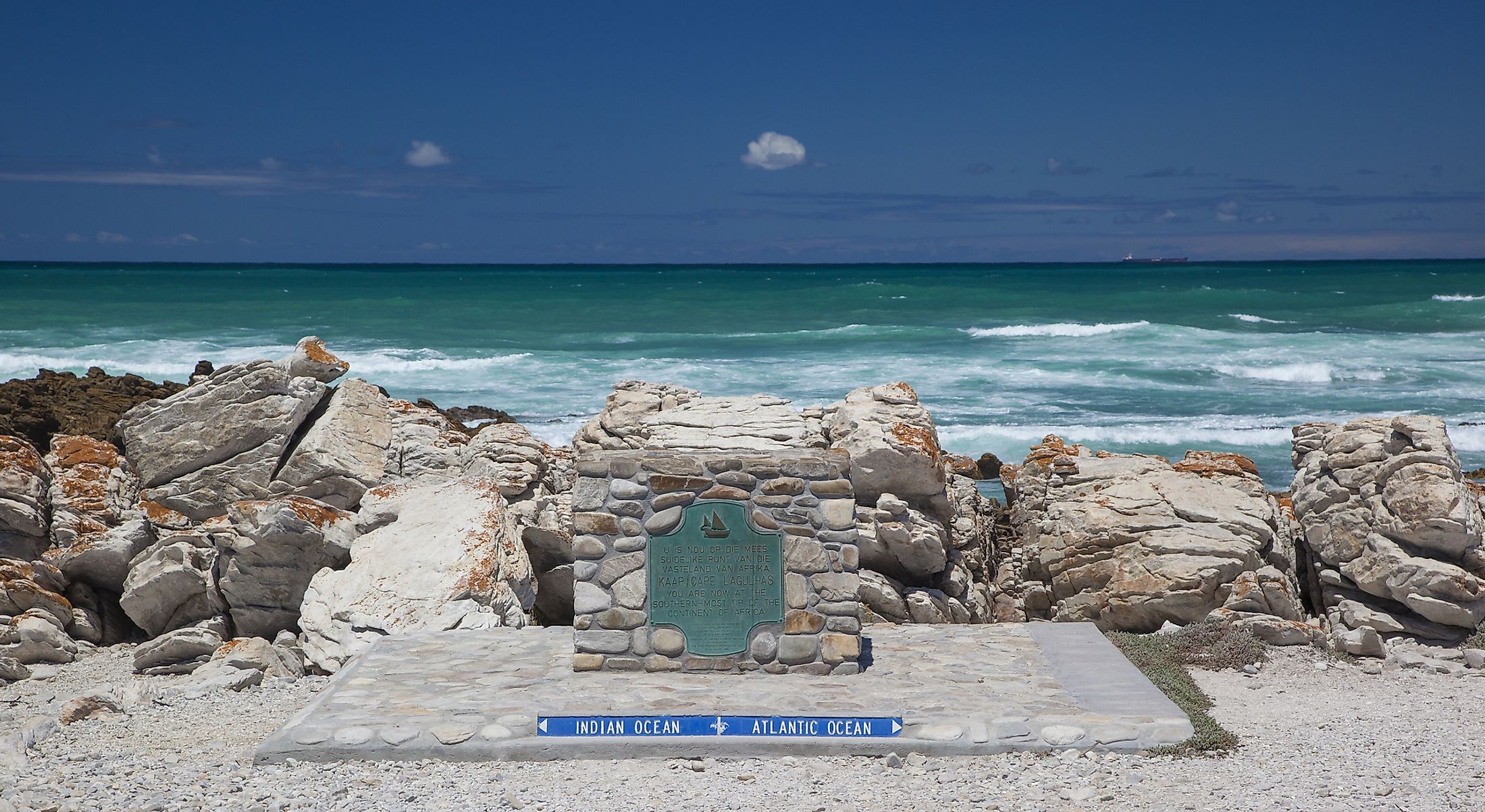
Cape Agulhas is a cape in the South African province of Western Cape and Africa’s southernmost point. The cape is located about 175 kilometers southeast of Cape Town and marks the beginning point of a line dividing the Indian and Atlantic Oceans. The cape’s name translates to “Cabo das Agulhas,” a Portuguese word for “Cape of Needles.” The Portuguese navigators named the cape “Agulhas” because the compass needle always pointed to the true north and coincided with the magnetic north. The “needles” may also refer to the reefs and rocks that are a nightmare to sailors. The cape is notorious for high waves and winter storms that have wrecked many ships, including Meisho Maru (one of the attractions in the Agulhas National Park).
Geography

Cape Agulhas is Africa’s southern tip, located about 175 kilometers southeast of Cape Town, South Africa’s oldest town and legislative capital. It is about 30 kilometers south of Bredarsdorp, famous for the Shipwreck Museum. Administratively, Cape Agulhas falls within the Western Cape’s Overberg District, specifically Cape Agulhas Local Municipality.

The cape is bordered to the west by the Quoin Point, Africa’s second most southern tip, while Cape Infante is further east of Agulhas. The tip of Africa is denoted by the white and red Cape Agulhas Lighthouse, established in 1849. The lighthouse was also constructed to reduce the number of international ships succumbing to the dangerous seas.

The Agulhas Bank, one of the richest fishing grounds in the Southern Hemisphere, has an average depth of 60 meters for about 250 km but plunges 1800 meters deep into the abyssal plain. The cold Atlantic Ocean and the warm Indian Ocean meet in the Bank region, with the convergence of the two oceans leading to treacherous sea conditions. The warm Agulhas Current flows southwards along Africa’s east coast then turns back into the Indian Ocean. While returning, the warm current pinches off part of the Agulhas rings (ocean eddies) drifting into the neighboring ocean and transports large amounts of salt and heat into the Atlantic.

The Cape of Agulhas’ coastline is gradually curving and comprises sand and rocky beaches. The rocks forming the cape are part of the Table Mountain Group, also known as Table Mountain Sandstone. The rocks are closely related to those on the cliffs of the Cape of Good Hope, Cape Point, and the Table Mountains.
Climate

The cape region experience a mild Mediterranean climate with little or no rainfall and temperature variation. It receives an average rainfall of between 400 and 600 mm annually, with most rains coming in winter. Agulhas records a temperature high of 36.1 degrees Celsius and a low of 4.4 degrees Celsius. June to September is the coldest season, with daily mean temperatures falling below 15 degrees Celsius, while January and February are the hottest months.
Shipping Hazards

Large, sudden rogue waves and winter storms are common in the sea near the Cape of Agulhas. The waves can reach a height of 30 meters and easily sink even large water vessels. The notorious storms and waves result from the strong westerly winds (Roaring Forties) in the Southern Hemisphere and the cold Antarctic Circumpolar Current (ACC) that flows against the Agulhas Current. The conflicting water current, westerly winds, and the shallow Agulhas Bank make the ocean region treacherous for ships. Over 150 ships have sunk in the region in the past years, with shipwrecks littering the coast.