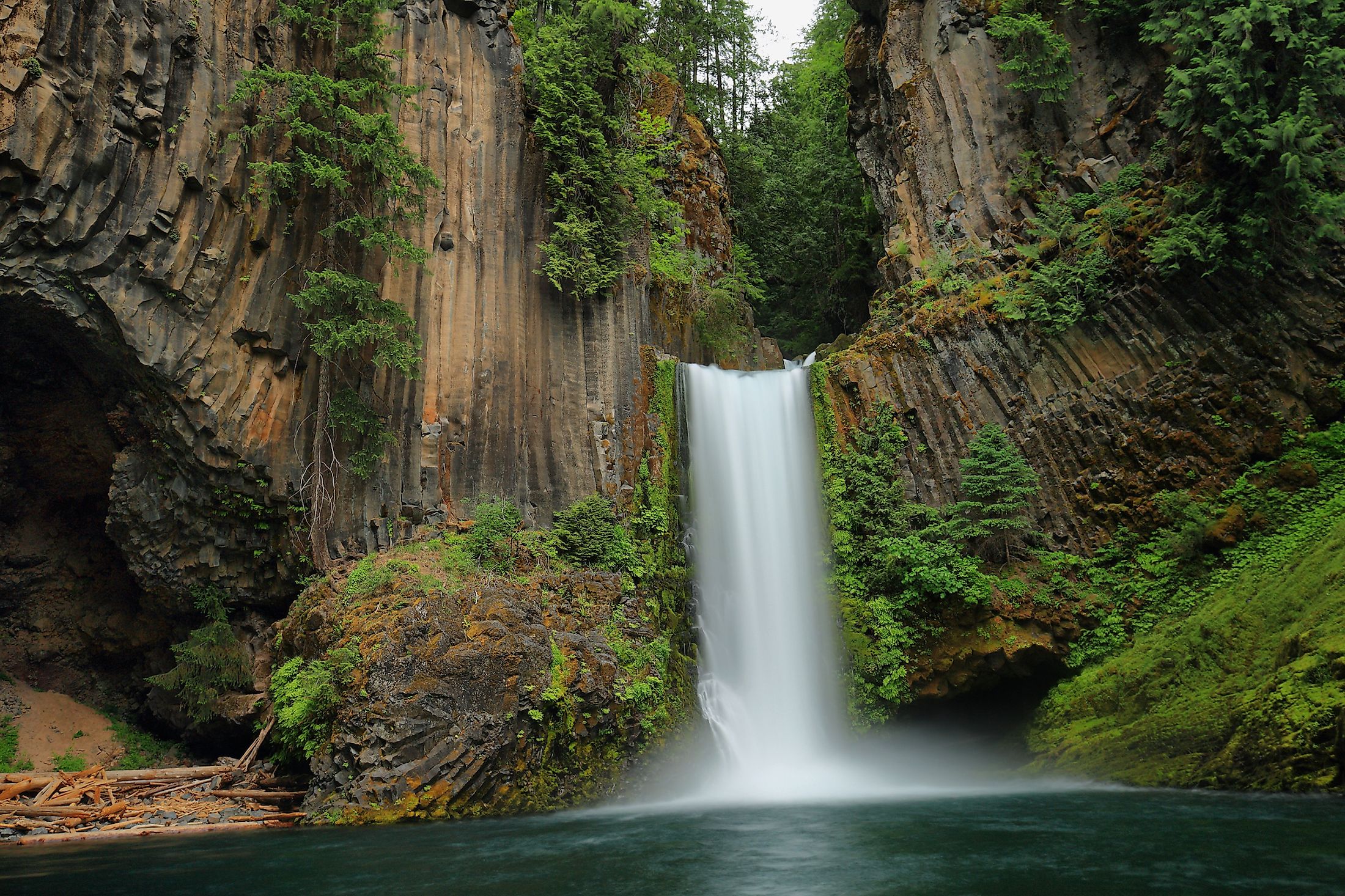
Toketee Falls
Toketee Falls is one of the best-known waterfalls located on the North Umpqua River in Douglas County, Oregon, United States. The waterfall is located approximately 93 kilometers to the east of the city of Roseburg near Oregon Route 138. The waterfall is 37-meters high and it drops in two stages. The name “Toketee” is derived from the native Chinook Jargon, meaning “pretty” or “graceful”.

There is a series of two hundred steps along the sides of the canyon to the Toketee Falls, ending at the viewpoint platform above the chasm of the amphitheater where the waterfall plunges. At the trailhead, the 4-meter diameter Toketee Pipeline is passed, and it allows the diversion of the North Umpqua’s water to a powerhouse downstream. This artificial taming of the river allows the waterfall to flow consistently all year long. Toketee is known to be one of the most photographed waterfalls in the state and is a natural touristic hotspot, attracting hikers and tourists who are yearning to take a dip in the pool below the falls. The United States Board on Geographic Names officially named the falls in 1916, replacing alternate names like Ireland Falls and Toketie Falls.
Structure Of The Toketee Falls
Toketee Falls is known for its spectacular plunge over a sheer wall of basalt formation that frame the two-stepped falls. The North Umpqua River has carved a sinuous gorge out of the lava flow issued from vents north of Mount Bailey. Two tiers are visible from Toketee Falls Viewpoint: the 12-meter upper falls which plunge into a pool flanked by a deep alcove, and the 24-meter lower falls that plunge into a larger pool, in addition to a third tier which is not visible to viewers up the narrow defile of giant potholes above the main falls.
Visiting The Toketee Falls

Being only an hour away from Roseburg, Toketee Falls is easy to find and does not require any special type of vehicle or off roading. The walk to Toketee viewpoint is beginner-friendly, as people of all ages and fitness levels have attempted the path. The trailhead leads to the picturesque Toketee Falls via the 643-meter Toketee Falls Trail. This trail leads to a platform from which the river can be seen cascading through the narrow gorge. The trail crosses a footbridge over a stream and enters an old-growth riverside forest of Douglas-fir, western hemlock, western red cedar and vine maple spreading in the understory. The North Umpqua River flows through a boulder course to the left. Steps leads up passing a spur to a rocky lookout over the river. There is a viewpoint over big potholes carved by the river’s flow. After a long flight of stairs reaching the side of the canyon, the trail rises and drops before another set of stairs lead to a view over the narrowing gorge. The route wraps around the slope and descends in another set of stairs to the viewpoint which offers view over the columnar basalt amphitheater.
Hydroelectric Power Generation
PacifiCorp, an electric power company in the United States, is responsible for the regulation of a dam built upstream the waterfall. This dam regulates the reduced water flow over the falls, and it also led to the formation of a reservoir now known as Toketee Lake. Initially, the North Umpqua River was allowed to flow freely over the falls, but this flow has been reduced by a penstock that utilizes the drop of the falls to generate hydroelectricity.