The Suez Canal
The Suez Canal is an artificial waterway between southern Asia and northern Africa that connects the Red Sea to the Mediterranean Sea via the Isthmus of Suez. The canal substantially reduces the sailing distance between East Asia and Europe and offers a more direct route between the Indian Ocean and the North Atlantic Ocean through the Red Sea and the Mediterranean Sea. The Suez Canal, excavated from 1859 to 1869, is owned by the government of Egypt and managed by the Suez Canal Authority. The canal is a critical shipping artery, serving over 50 vessels or ships daily.

Construction
The idea of constructing the Suez Canal dates back to the late 15th century when Venetian leaders contemplated constructing a waterway between the Nile the Red Sea, but Egypt’s conquest by the Ottoman Empire in 1517 put to rest the Venetians' plan. In the 16th century, the Ottomans contemplated digging a canal connecting the Mediterranean and the Red Sea and link Constantinople to the Indian Ocean trade routes. However, the project was too costly to be completed. In 1804, French Emperor Napoleon Bonaparte also abandoned a similar project because of the cost factors.

In 1958, French diplomat Ferdinand de Lesseps formed the Suez Canal Company to excavate a canal connecting the Mediterranean and the Red Sea. The canal’s construction began on April 25, 1859, and was completed after ten years. According to multiple sources, at least 30,000 people worked on-site at any given time, and more than 1.5 million people of different nationalities were involved in the construction. The Suez Canal was officially opened on November 17, 1869. Egypt, France, and Britain jointly owned the canal until 1956, when it was nationalized by the Egyptian government, leading to Suez Crisis.
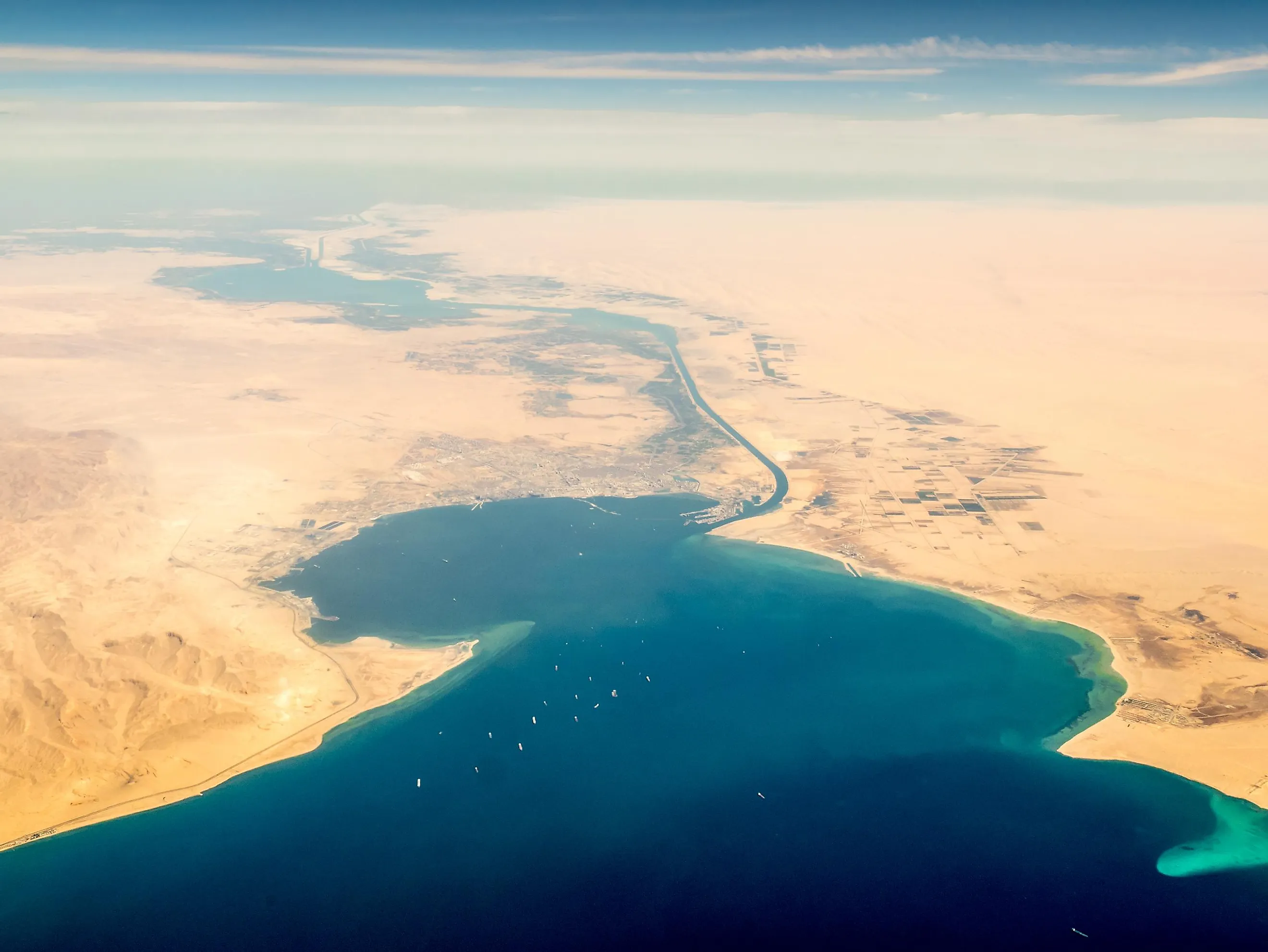
Layout

The Suez Canal extends from Port Tewfik in Suez City to Port Said in northeast Egypt. At the time of its opening in 1869, the canal was 164 km long. But several enlargements and developments have increased the canal’s total length by about 30 km to 193.3 km. It is 205 m wide and 24 m deep.
Although the Suez Canal can handle larger ships and more traffic than most canals, including the Panama Canal, it can only allow passage of water vessels of up 240,000 tons deadweight or 20 meters draft. The ships or vessels must also not exceed 68 m in height above the water surface and a beam of 77.5 meters (width at the widest point). Supertankers and larger ships can reduce their drafts by offloading their cargo onto smaller cargo-ship owned by the Suez Canal Authority and reload once they have transited the canal.
Navigation

From its inauguration in 1869 to August 2015, the Suez Canal was a narrow waterway that could not serve two-way traffic. Ships passed through the canal in convoys and used by-passes, including Port Said, Ballah, Tinsah, and Deversoir. It took a ship 12-16 hours to sail through the canal. After an expansion project in 2014, the canal now caters to only regulated two-way traffic that is executed in shifts. Ships approaching the canal must radio the harbor when they are at least 24 km away from the Safe Water Mark. The northbound convoy departs at 4:00 AM from Suez, while the southbound convoy departs at 3:00 AM from Port Said. This way, when the two convoys meet in the canal, they will be located in a portion that has been widened to allow two-way traffic.


