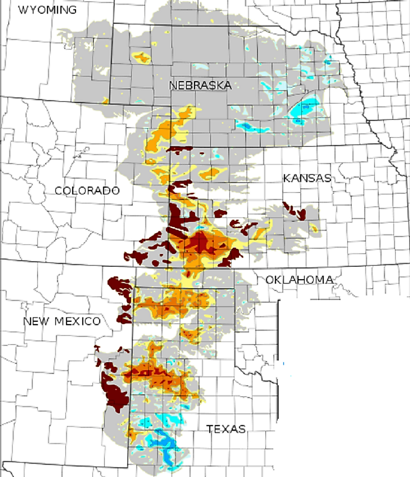
Where Is The Ogallala Aquifer?
Description
The Ogallala Aquifer is the largest aquifer in the United States. It occupies an area of 174,000 square miles, spreading across 8 American Great Plains States, according to the US Geological Survey. These states are Colorado, Kansas, Nebraska, New Mexico, Oklahoma, South Dakota, Texas, and Wyoming. The aquifer occupies 11 percent of Texas’ state land. The water volumes in the Ogallala Aquifer are estimated to amount to 3.3 billion acre-feet of water, more than enough to fill Lake Huron, with the remainder left over being enough to fill a fifth of Lake Ontario, according to a Kansas University Study (KSU). The aquifer is formed by sand, gravel, clay, and silt, and has a maximum thickness of 800 feet, according to the Texas Water Development Board. Its freshwater-saturated thickness averages 95 feet.
Formation
The formation of the Ogallala Aquifer started 24 million years ago, and ended 1.8 million years ago, according to an MIT Mission 2012 Clean Water report. This happened as sand and gravel that had eroded from the Rocky Mountains were carried eastwards by large rivers, and these sediments ended up covering the Great Plains landscape. The highly permeable and porous sand and gravel began filling with water during the wet climate patterns characteristic of the region around 10,000 years ago. The deposition of the Ogallala formation began in the late Miocene and into the early Pliocene age, at which time the local climate became more arid, and the upwarp of the High Plains caused deposition to end. Subsequently, net erosion began to start, according to a study by the North Plains Groundwater Conservation District.
Importance
Roughly 30 percent of all groundwater used for irrigation in the U.S is drawn from the Ogallala Aquifer, according to the US Department of Agriculture-Natural Resources Conservation Service. Within the 8 states it’s located, it provides water to households, as well as wheat, cotton, and corn plantations in what is a semi-arid region. The Ogallala Aquifer also sustains the lucrative cattle sector that has allowed Kansas to provide 40 percent of the nation’s supply of packaged beef, making the state the 2nd in cattle slaughter, and 3rd in red meat production nationally, according to a Kansas State University study. Its water is also used for industrial and municipal development. Also, over 170,000 wells tap their waters from the Ogallala Aquifer, and 50,000 of those are in Northwest Texas, according to a University of Texas study. The aquifer is also directly responsible for facilitating $20 billion in annual food and fiber production.
Threats
Precipitation from the High Plains is the means by which the Ogallala Aquifer replenishes much of its water reserves. Annually, the average precipitation that recharges the aquifer is 21.59 millimeters on average (in terms of how much actually reaches the groundwater to recharge it), according to the US Geological Survey. With more and more of the water being used to irrigate farmlands, water levels in the Ogallala Aquifer have dropped in recent decades. Irrigation water is being used faster and more than the precipitation moves through the rocks and sediments to replenish the aquifer, according to a report by the Encyclopedia of the Great Plains by the University of Nebraska-Lincoln. Much of the depletion has been concentrated in southwest Kansas and the Texas Panhandle. In its lifetime, the Ogallala Aquifer water table has dropped 70 meters in the Panhandle, and 38 percent of the groundwater in the underlying aquifer Western Kansas has been used up as well, according to another Kansas State University study. Around the Texas Panhandle the soil is fine-grained, thereby hindering permeability according an MIT Mission 2012 Clean Water report. If completely drained, the Ogallala Aquifer would take 6,000 years to be refilled. The MIT Mission 2012 Clean Water study reports the current withdrawal rate of the aquifer is too high to be sustained for the next 100 years.
Restoration Efforts
In the 8 states the Ogallala Aquifer is located, efforts are ongoing to encourage water conservation among the region's farmers and ranchers to use less water and improve water quality, while maintaining their farm and range lands in an economically productive manner. These conservation efforts are through the Ogallala Aquifer Initiative (OAI), which is also advocating the use of less agricultural chemicals to reduce water pollution, as well as to extend the useful life of the aquifer. The OAI is also advising farmers to keep crop nutrients and livestock out of the waterways.