Amur River
Amur River, also known as Heilong Jiang, is a major waterway in East Asia and the world’s 10th longest river. It is China’s third-longest river after Yangtze and Huang Ho and the longest river flowing through Russian Far East. The river begins at the confluence of Argun and Onon-Shilka near Pokrovka in Russia, then flows east and southeast for approximately 2,824 kilometers before emptying into the Strait of Tartary. However, the Amur-Argun river system is 4,444 kilometers long, making it Asia’s 4th longest river. Amur forms part of the border between Northeastern China and Southeast Siberia. The river’s modern name (Heilong Jiang) translates to Black Dragon River.
Features Of The Amur River

The Amur watershed covers an area of approximately 1.855 million square kilometers and drains much of the Russian Far East and Northeastern China. Its headwaters rise in Khan Khentii Strictly Protected Area (Mongolia), Greater Khingan in Russia, and Northeastern China. The Amur proper flows for about 2,824 kilometers and drains into the Strait of Tartary near Nikolayevsk-on-Amur. It discharges an average of 10,739 cubic meters of water per second into the strait and a maximum of 30,700 cubic meters per second.
The Amur is divided into three sections; Upper Amur, Middle Amur, and Lower Amur. The Upper Amur begins at the confluence of Argun and Shilka and flows for about 900 kilometers to Zeya’s mouth. The Middle Amur runs for 970 kilometers from Zeya to Khabarovsk, while the Lower Amur flows from Khabarovsk to the Strait of Tartary for another 970 kilometers. The entire river rises at an elevation of 303 meters and falls to sea level at the mouth.
Course Of The Amur River

Origin
The Amur River begins its flow at the confluence of the Argun and Shilka River, about 2,824 kilometers northwest of its mouth. The Shilka River begins in Siberia at the junction of Onon and Ingoda Rivers, whose sources are in the Khentii Range. Shilka flows for about 560 kilometers before meeting the Argun River at the Russia-China border. The Argun River rises in the Greater Xing’an Range in Inner Mongolia, China, approximately 1,620 kilometers from its junction with the Shilka River. It receives several tributaries before reaching the China-Russia border, including Gazimur, Uryumkan, and Urov. The Argun runs on the Russia-China border and meets the Shilki near Pokrovka.
Upper Amur
The Shilka and Argun Rivers confluence at an elevation of 303 meters and marks the beginning of the Amur River. The Upper Amur flows east on the Russia-China border, then gently bends southeastwards, maintaining its flow on the border for about 400 kilometers. The river’s upper reaches flow between Amarzar Range and the Greater Khingan Range and past several towns, receiving water from several tributaries. The Huma He River joins the Upper Amur at Huma. Then, the river continues southwards, flowing between Heihe (China) and Blagoveshchensk (Russia). The river widens as it flows south and receives Zeya near Blagoveshchensk. Zeya currently contributes 16% of inflow into the Amur, down from 50% because of the flow regulations.

Middle Amur
The Amur-Zeya junction marks the beginning of the Middle Amur River. This section first flows into the Zeya-Bureya Depression and curves east, then southeast as the river approaches its confluence with the Bureya River. The river continues south for another 250 kilometers without receiving any major tributary, flowing past the spurs that extend from the Bureya Range. Then, it enters a narrow gorge and flows through Xiao Hinngan Range, where its speed and depth increase rapidly. The Middle Amur briefly turns east and receives Songhua (largest tributary) at Tongjiang, then turns northeast and flows towards Khabarovsk, where it receives the Ussuri River.
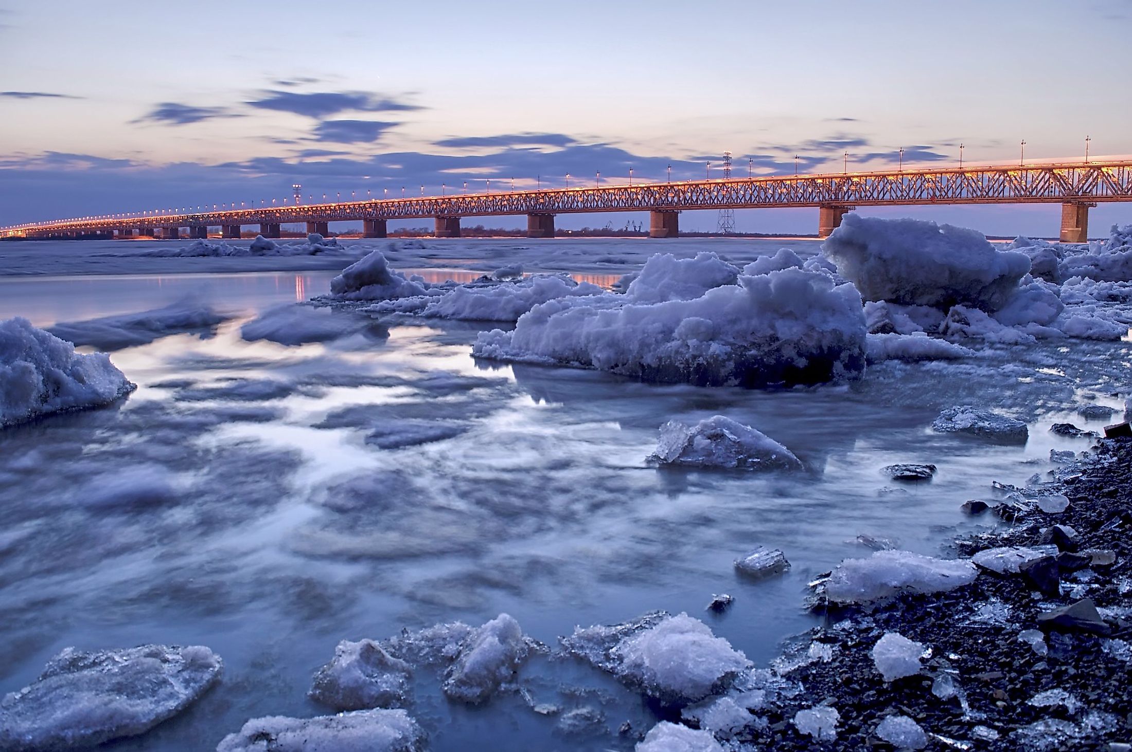
Lower Amur
At Khabarovsk, the Amur River is only 370 kilometers northeast of the East Sea (Sea of Japan). However, Sikhote-Alin Range diverts the river so that it does not empty into the East Sea directly. Instead, the Amur flows for another 970 kilometers before draining into the sea via the Strait of Tartary. The Lower Amur leaves the Russia-China border and continues northeast from Khabarovsk. The river’s lower reaches flow through a wide valley, past Amursk and Komsomolsk-na-Amure. The river plain narrows near Komsomolsk-on-Amur and flows for about 145 kilometers through a scenic forest valley. Then it flows through the Udil Kizinsky hollow until Bogorodskoye. It emerges from the hollow and flows on a low-lying plain, where it receives the Amgun, the last major tributary. Then, the Lower Amur turns east and enters the strait through the 20-km-long estuary.
Climate
The climate of the Amur basin is affected by the seasonally alternating monsoon winds and its northern location. The continental air mass dominates the river basin during polar winter, causing dry weather and a temperature range of -20 to -33 degrees Celsius. During summer, the river basin receives maritime air mass, causing the temperature to range between 18 and 22 degrees Celsius. The Amur basin receives uneven precipitation. The southern portion receives up to 900 mm annually, while the middle section receives a maximum of 600 mm. The western part receives the lowest precipitation, ranging between 300 and 400 mm.
Flora And Fauna Of The Amur River

The Amur Basin’s vegetation lies mostly in the Taiga zone, with larch as the most common species in the area. The drier parts contain fir, spruce, and pine, while the eastern portions have Amur cork tree and Korean pine. Steppe grassland dominates the west, with conifer and mixed broad-leaved forests are found on the south. The river itself contains over 123 fish species, including 25 species of commercial value. Most fish species, about 100, are found in the Lower Amur. This river is home to some 20 indigenous broadhead and carp species. Other species include Siberian Salmon, burbot, and the sig, with Kaluga as the largest species.
Brief History
The Amur basin was originally inhabited by several tribes, including Nanai, Buryat, Nivkh, Yakut, Orok, Udegey, and several Machu people. For most of these tribes, the main occupation was fishing and hunting. The Machu people regarded the river as sacred and named it “sahaliyan ula,” meaning “Black River.” Russian traders and explorers began developing an interest in the area in the 17th century. Russian explorer Vasily Poyarkov explored the basin and the estuary between 1644 and 1647, followed by Yerofey Khabarov from 1649 to 1651.
The Treaty of Nerchinsk allocated the entire river basin to China in 1689. Despite the treaty, Russians and Europeans continued to occupy north Amur. By 1860, Russia had taken control of the land to Ussuri’s east and Amur’s north. Russian settlers moved into the region and built cities like Blagoveshchensk. Russians slowly spread over the basin, with their influence reaching Harbin and Dalian. The Amur River remains an important symbol in Russian-Chinese relations, with the river becoming popular during the Sino-Soviet tension of 1956-66.


