What Is The Cryosphere?
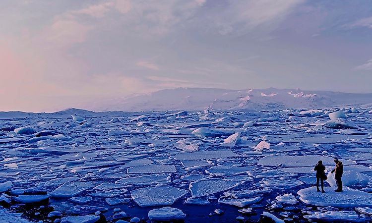
What Is The Cryosphere?
The cryosphere is the frozen part of Earth’s surface. This includes glaciers, snow, sea ice, freshwater ice, permafrost, ice caps, and ice sheets. The cryosphere plays a significant role in the global climate by influencing hydrology, clouds, precipitation, and circulation of the atmosphere and the oceans. The term cryology refers to the science of cryospheres and deglaciation is the loss of the cryosphere (such as the reduction of global ice content due to global warming).
Physical Properties Of The Cryosphere
The existence of the cryosphere varies widely depending on its specific location around the world. For example, snow and freshwater ice may exist only through winter seasons in many places, whereas many glaciers have been frozen for over 10,000 years. Antarctica is home to the majority of global ice volume, however, the northern hemisphere is home to the largest cryosphere area. Climate researchers rely on measurements of the cryosphere for information about global climate change.
The cryosphere affects the world’s climate via three distinct properties: surface reflectance, thermal diffusivity, and latent heat.
Surface Reflectance
Much of the cryosphere reflects the sun’s solar radiation; this reaction is known as surface reflectance. Surface reflectance is measured by the difference between reflected and incident solar radiation, known as albedo. In other words, albedo is the reflecting power of a particular surface. Some of the highests rates of albedo, between 80% and 90%, are found in areas with year-round snow coverage.
During autumn and spring, the rates of albedo are higher near the poles. Some of this increased reflectivity is absorbed by cloud coverage, which is particularly high during these same seasons. April and May have the highest levels of solar radiation in the world’s snow-covered areas and therefore, have the greatest effect on the global radiative balance.
Thermal Diffusivity
Thermal diffusivity refers to the rate at which heat can transfer through a particular object. It is determined by dividing density and heat capacity. In layman terms, it is also known as how “cold to the touch” a particular object may be. Heat travels significantly slower through ice and snow than through air. This means that snow and ice help insulate the ground and water below from heat transfer. Heat is even slower when the snow and ice cover reaches between 30 and 40 centimeters. This works to keep everything under the snow and ice slightly warmer during winter months and slightly cooler during summer months. Thermal diffusivity also plays an important role in the climate.
Latent Heat
Latent heat refers to energy that is released or stored in constant-temperature conditions. For example, the latent heat required to melt ice is relatively high. In other words, in the cryosphere, latent heat is the energy required to change the state of water (from gas to liquid to solid). The heating and cooling of snow and ice coverage contributes to weather changes across the globe. As water evaporates from the earth’s surface, it becomes moisture in the atmosphere. For example, the summer monsoon season in Eurasia is thought to be caused by the cooling characteristics of snow and moist soil during the spring.
Types Of Cryosphere
As previously mentioned, the cryosphere refers to all frozen areas around the world. This includes: snow, sea ice, freshwater ice, frozen ground, and glaciers.
Snow
Snow makes up the second largest area of the cryosphere, covering over 18 million square miles. Most of this area is in the Northern Hemisphere and ranges from 17.9 million square miles in the winter to just 1.46 million square miles during the summer. North American snow coverage has remained nearly the same over the majority of this century despite increased springtime temperature. However, this is not the case in Eurasia, where snow coverage has decreased.
Melting mountain snow coverage contributes most of the water to streams and groundwater around the world. This helps explain why mountains make up approximately 40% of global protected areas. Researchers expect global climate change to affect precipitation levels and the amount and timing of snowmelt. This will, in turn, affect worldwide water management procedures.
Sea Ice
Large portions of the ocean near the north and south poles are covered in ice. In the Southern Hemisphere, sea ice covers between 6.56 million square miles and 7.7 million square miles in September. In February, this number can drop to as low as 1.15 million square miles. The seasonal variation is not so stark in the Northern Hemisphere. Sea ice in the Arctic region has been on a steady decrease of approximately 2.7% each 10 years from 1978 to 1995. From 1978 to 2012, that measurement changes to a 3.8% decrease. The Antarctic region, however, has indicated an increase of around 1.3% every decade.
Freshwater Ice
Freshwater ice can be found in rivers and lakes. Typically, it is a seasonal occurrence and not usually found year-round, like sea ice. Because this ice coverage occurs per season and over a significantly smaller area, its effect on climate is minimal. Records of annual ice coverage and breakup can, however, indicate changes in global climate. This is particularly true of lake ice. River ice breakup is a less reliable source of climate change information because it is largely influenced by both changes to water flow and surrounding temperatures.
Frozen Ground
Frozen ground includes areas with permafrost. In the Northern Hemisphere, frozen ground covers an area of around 20.84 million square miles. Areas of permafrost are not as easily measured, but estimates suggest it covers 20% of the land area in the Northern Hemisphere.
In warmer seasons, the depth of frozen ground has been shown to influence both hydrologic and geomorphic events. The influence of permafrost, however, has yet to be identified. This is because permafrost consists of both ice and soil and rocks at freezing temperatures. The temperature of Alaskan permafrost has increased by 2.4°C over the last few decades.
Glaciers
Glaciers and ice sheets are considered part of the cryosphere. Both consist of large ice masses that sit on top of land. These ice masses melt, become thinner, and spread wider as they move across land. Approximately 77% of the world’s freshwater is found in ice sheets. The water in glaciers and ice sheets may remain frozen for between 100,000 and 1 million years.
Researchers are still studying the effects of glaciers on global climate change. Currently, it is believed that they have little influence over global temperatures. However, glaciers have been melting at increased speeds over the last few decades. Estimates suggest that during the 20th century, these melting glaciers and ice sheets have contributed between 33% and 50% of the rise in sea levels.
As glaciers and ice sheets reach coastlines, they tend to break off into the ocean. This action is referred to as calving. Calving is thought to be responsible for the majority of mass loss seen in glaciers and ice sheets. The Greenland ice sheet is currently experiencing significant loss, however, the Antarctic ice sheet has been growing. Despite this, scientists remain concerned that the West Antarctic ice sheet will collapse into the ocean. Its collapse would result in a sea level rise of between 19.68 feet and 22.96 feet, enough to cause significant destruction to coastal communities around the world.