What Is A Fjord?
What Is A Fjord?
Fjords are some of the most dramatic geological formations on earth. A fjord is a long, deep, and narrow sea inlet. An inlet is a type of bay, where the shoreline cuts into the mainland and fills with seawater. It is surrounded on 3 sides by steep cliffs. Its most distinguishing feature is that it is longer than it is wide. If the inlet is wider than it is long, it is considered a bay and not a fjord. Fjords can be found in the following locations: Alaska, Washington, Norway, Sweden, Iceland, Greenland, Newfoundland, Scotland, British Columbia, Chile, and Labrador (among others).
How are Fjords Formed?
Fjords have been shaped throughout the span of several ice ages by slow-moving glaciers. As the glacier moved, it cut away at the top layers of ice and into the sediment below. Melting waters also carved away into the land, meaning that many fjords are actually deeper than the sea that feeds into it. Where the fjord meets the sea, also known as the mouth, many glaciers left behind shill or shoal rock deposits. Because the mouth is a shallower opening than the body of the fjord, it results in extremely fast-moving water (this includes strong currents and saltwater rapids).
What Are Some Common Features Of Fjords?
Although fjords share a common formation story, they do not all share the same geological features. Some of these varying features include hydrology, epishelf lakes, coral reefs, and skerries. Below is a closer look at each characteristic:
Hydrology
Hydrology refers to the behavior or characteristics of the water within the fjord. In most places, the warmer temperatures of summer result in snow and ice melting into local rivers. These overflowing, freshwater rivers often flow into the fjord, mixing with the saltwater. This mixture creates brackish water, the surface of which rises above the surface of the open sea. Because of the difference in surface elevations, the top layer of water flows into the sea. At the same time, the bottom layer of saltier water moves into the fjord. Some of the deepest waters remain very cold and do not move. This lack of movement means the water does not have a sufficient level of oxygen and is unable to support wildlife. In some fjords, the layer of brackish water on top of the saltwater is so deep that the fjord freezes over. This results in no oxygen throughout the fjord, creating large “dead zones”. Some fjords receive very little river water and are therefore not affected by this phenomenon.
During the winter, the hydrology of fjords is not affected by freshwater. Because of this lack of freshwater, the surface water and deeper water are able to mix more easily. Wind influences the flow of the current, pushing saltwater from the coast to the inner areas of the fjord. The water is more likely to have a constant flow in this case.
Epishelf Lakes
Another feature of some fjords is the presence of epishelf lakes. These lakes occur when melted fresh water becomes trapped under a floating ice shelf. This freshwater does not mix with the saltwater below, but rather floats on top of it. Sometimes this forms what is known as an isolated ecosystem.
Coral Reefs
Previously undiscovered, some researchers found coral reefs in the fjords of Norway in 2000. Further research discovered that these coral reefs could be found in fjords stretching from the northern regions of the country to the southern. It is now believed that these coral reefs have contributed to the rich marine life of Norway, which has resulted in its successful fishing industry. Research is ongoing to identify the variety of species located within.
The fjords of New Zealand are also hosts to coral reef ecosystems. These are unique because a deep layer of freshwater allows these typically deepwater coral reefs to exist in water that is much shallower than normally required.
Skerries
In many places where fjords are commonplace, the shorelines are covered in these geological formations. In fact, so many of these fjords have developed that they often cut the shoreline into thousands of islands. Some of these islands are significant in size and covered in mountains, while others are small and appear to be little more than a large rock sticking out of the water. Skerries are most commonly found at the mouth of fjords. Sometimes these skerries form a fjord that is parallel to the coastline, which creates a protective channel with calm waters that are easy to navigate.
Confusion Over the Word: Fjord
Although the English language has adapted the usage of the Scandinavian word fjord, there is some confusion surrounding its meaning. For example, in the Danish, Swedish, and Norwegian languages, the term fjord is used more generally than in English or scientific usage. In its general sense, fjord can refer to: long and narrow freshwater lakes, rivers, bays, lagoons, and sounds.
Some examples of this confusion can be seen in Montenegro’s Bay of Kotor, which is sometimes referred to as a fjord but is actually a flooded river canyon. In Croatia, the Lim Bay is also commonly called a fjord, but it was not created by a glacier. Another example is in Denmark, where numerous inlets are called fjords in the local language. However, according to the scientific definition, Denmark does not have fjords.
UNESCO World Heritage Site
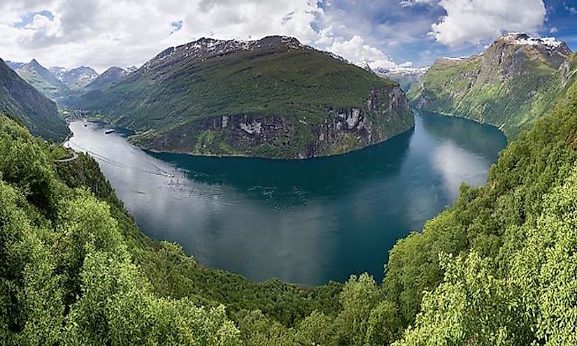
As previously mentioned, fjords are unique and beautiful landscapes. In recognition of their cultural and environmental significance, UNESCO included the West Norwegian fjords as a World Heritage Site on July 14, 2005. This area includes two fjords: the Geirangerfjord and Nærøyfjord. These fjords were enrolled in the UNESCO World Heritage List because, as stated by the Committee, they are some of the most beautiful and outstanding examples of fjords in the world.
The West Norwegian Fjords run lengths of around 310 miles and reach depths of between 32 feet and 1,640 feet, making them some of the longest and deepest fjords in the world. The jagged mountains surrounding the waters reach altitudes of around 4,593 feet above sea level. Additionally, this area is covered in deciduous and coniferous forests, waterfalls, rivers, glacial lakes, and pastures.