The Four Northeastern National Forests
Natural forest cover has diminished over the years due to human activities such as clearing land for agriculture and settlement. The current global forest cover is about 31% of the land surface, a portion that is very low compared to the pre-industrial days. In the US, forest cover has also gone down due to deforestation. As of 2014, there are 192.9 million acres of forest cover in the country representing about one-third of the total land surface. There are three categories of forest cover namely tree farm forests, secondary forests, and old natural forests. The leading motto in conserving forests is “Land of Many Uses” which leads to multi-use of the forestry resource.There are 154 national forests in the US managed by the US Forest Service. Most of national forests are managed together either as a single forest or separate forests. This article focuses on the on the four northeastern national forests in the US.
4. Green Mountain
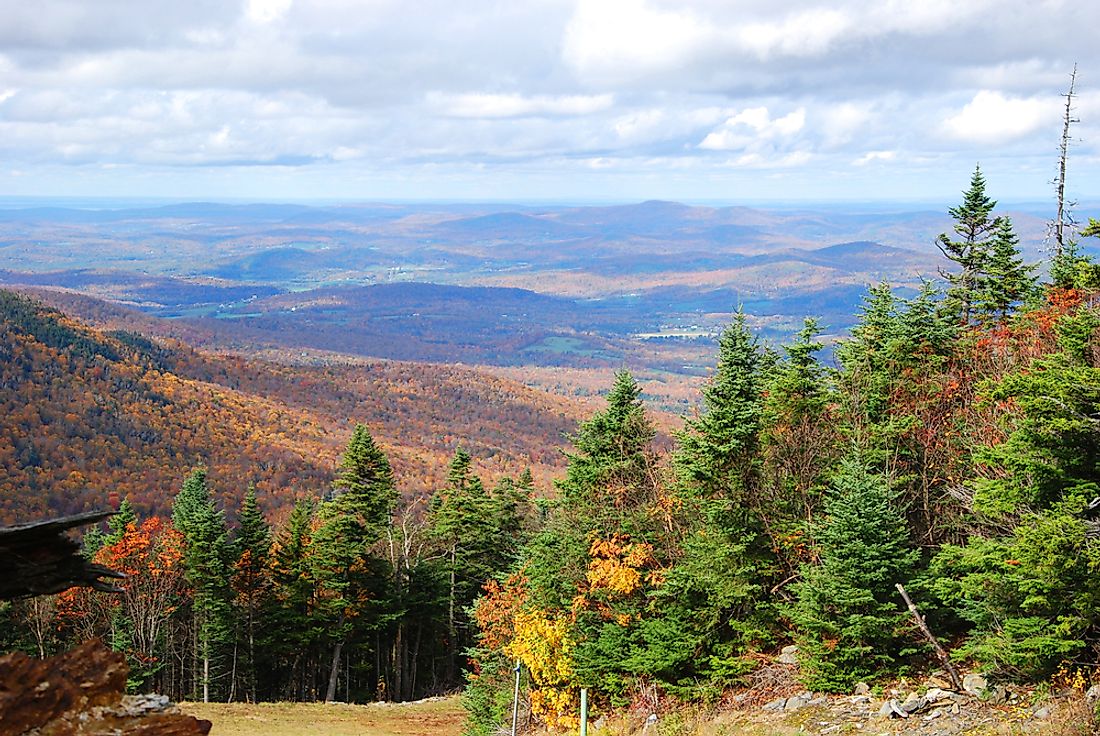
The Green Mountain is found in Vermont near Rutland City. It was established in April 1932 under the US Forest Service and occupies 399,151 acres. The move to legislate the forest was due to excessive logging, flooding, and frequent fire outbreaks. The Ecoregion supports a wide range of flora and fauna. Specific wildlife found in Green Mountain includes the black bear, coyote, white-tailed deer, and beaver. Various bird species like the wild turkey and the ruffed grouse are in plenty. Geographically, GMNF is divided into the central and southwest region with 8 wilderness areas. There are 3 designed trails that include the Long Trail, Appalachian Trail, and the Robert Frost National Recreation Trail. GMNF is famous for snowballing and cross country hiking activities. Conservation efforts have been enhanced through controlled logging of trees. In 2008, the American Reinvestment and Recovery Act (ARRA) came into effect and has assisted in reforestation. In 2009 a total of 429 acres were set aside for regeneration exercise. The Vermont trees are threatened by the emerald ash borer though there are efforts to control them.
3. Allegheny
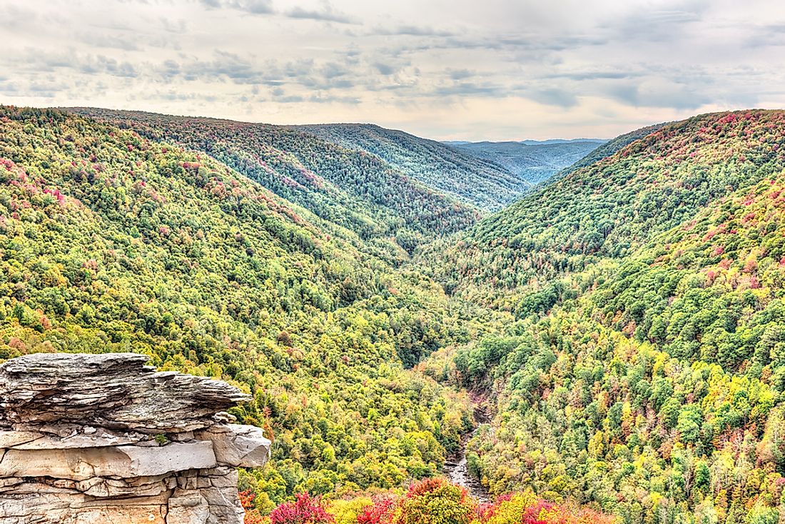
Allegheny National Forest is a dense forest in northwestern Pennsylvania. It covers a total area of 513,175 acres including Kinzua Dam which is located inside the forest. The administrative headquarters of the forest is Warren assisted by two ranger stations. Allegheny is located in oil and gas drilling region. Currently, there is a substantial amount of natural gas and oil being extracted from inside the forest. The Multiple-Use Sustained Yield Act of 1960 is a major legislation that emphasized on wilderness preservation, outdoor recreation amenities, and protection of wildlife and fish habitat. When the forest was established in early 1923, the forest service nurtured young trees after heavy logging witnessed in earlier years posed a great threat the existence of the forest. Frequent flooding, erosion, and wildfires were a constant occurrence. The forest grew gradually and is currently having trees as old as 70 to 100 years. From 1923 to date, there has been a research station where agroforestry officers carry out studies on the relationship between vegetation, weather, nutrients, and diseases. The forest has therefore been consistently monitored with each stage bringing benefits to flora and fauna. Allegheny National Forest offers recreation facilities like wildlife watching, skiing, and camping grounds. However, the conflict has arisen in the forest over rights to minerals between the Federal Government and private citizens. The government purchased the forest without having a written agreement on the ownership of subsurface and minerals beneath.
2. White Mountain
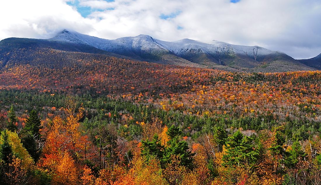
White Mountain National Forest (WMNF) is found within the famous White Mountains. The large part of the forest is in New Hampshire while a small portion of about 5.65% is in the Maine state. Established in 1918, the forest currently covers an area of 750,853 acres and is managed by the Forest Service. Major tourism attraction sites include the White Mountain trail, Kancamagus scenic drives, winter skiing, and Appalachian Trail. Because of its proximity to towns and its beauty, the forest attracts many visitors for outdoor recreation, hiking, and camping activities. The Forest Service has allowed controlled logging in this forest to control loss of some of the important plant species. Some of the wildlife species found in WMNF include bald eagle, beaver, moose, Canadian lynx, porcupines, foxes, and raccoon. To manage the forest effectively the forest service has divided it into 3 discounted areas. Six Wilderness regions were established within the forest to enhance monitoring of the forest. The regions are the Presidential Range that covers 27,380 acres, the Great Gulf (5,552 acres), Pemigewasset (45,000 acres), the Sandwich Range (35,800 acres), Speckled Wilderness (12,000 acres), and Wild River (23,700 acres). In 2006, the New England Wilderness Protection Act was passed that led to the formation of the Wild River region.
1. Finger Lakes
The vast Finger Lake National Forest occupies the County of Seneca and spreads to Schuyler County. It is location between Lake Seneca and Lake Cayuga in New York State. Established in 1985, the forest covers a total area of 16,259 acres. Finger Lake Forest is famous for having 30 miles long trails that transverse woodland, gorges, and ravine. Administratively the forest is in the Green Mountain National Forest unit which enhances multiple uses namely woodland, pastures, recreation, wildlife, and preservation of archeological and historic sites. The forest developed as a result of an effort by the state to buy out exhausted land from farmers after the great depression of 1890. Environmental degradation had led to the enactment of Federal Emergency Relief Act in 1933. An agency was formed to resettle the farmers elsewhere and concentrate on reforestation efforts within the land. Initially, the forest was managed by Soil Conservation Service under the Hector land Use Area (HLA). Later the HLA coordinated grazing of livestock within 100 miles radius near the forest without destroying the trees. With time trees grew in the region leading to the current dense forest. A major tourist attraction site is the which was constructed within the forest. The property is listed as a historic site and is associated with Camp Fossenvue.


