The Alpine Four-Thousanders
The International Climbing and Mountaineering Federation
The International Climbing and Mountaineering Federation, often referred to by its French name, Union Internationale des Associations d'Alpinisme (UIAA), is an organization that oversees research pertaining to mountaineering issues. It represents mountain climbers all over the world in order to ensure the safety and continued success of this sport.
What are the Alpine Four-Thousanders?
As part of its functions, the UIAA also maintains lists of mountains around the world, which include information about elevation, summit trails, records of ascents, and locations. The Alpine Four-Thousanders refers to the mountain peaks in the Alps that stand at 4,000 meters (13,123 feet) or higher. The UIAA lists 82 official Alpine Four-Thousanders. Of these, 48 are located in Switzerland, 38 in Italy, and 25 in France. This article takes a closer look at some of the tallest peaks on the Alpine Four-Thousanders list.
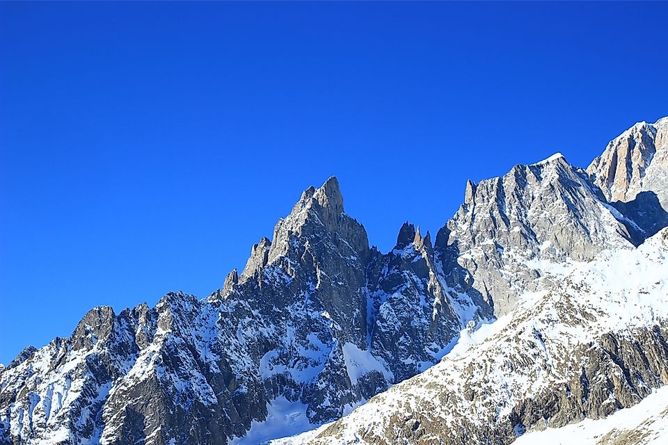
The Tallest Peaks of the Alpine Four-Thousanders
Mont Blanc
Mont Blanc is the highest mountain in the Alps, standing at 4,808.73 meters (15,774 feet) above sea level. It is located between the Haute-Savoie and Savoie regions in France and the Aosta Valley in Italy, within the Graian Alps range. The first successful summit was accomplished by Jacques Balmat and Michel Paccard in 1786, which was the earliest climb of any of the Alpine Four-Thousanders. In 1808, Marie Paradis became the first woman to complete the ascent. The next ascent was not accomplished until 30 years later, also by a woman. Interestingly, prior to holding the United States presidency, Theodore Roosevelt led an expedition on this mountain in 1886. Mont Blanc has the highest number of fatalities on record (over 6,000). Approximately 100 deaths per year occur here, making this the most dangerous mountain in the world.
Mont Blanc de Courmayeur
Mont Blanc de Courmayeur is the second highest of the Alpine Four-Thousanders and is recorded at 4,748 meters (15,577.43 feet) in elevation. It is located on the southeast ridge of Mont Blanc. On August 18, 1822, F. Clissold and J. M. Couttet became the first climbers to reach the top with the help of 5 guides. The Bosses ridge provides the easiest trail to the summit, while the Brouillard and Peuterey ridges are more difficult. The exact location of this mountain was previously disputed by the Italian Geographic Military Institute, which claimed it was entirely within Italian borders, while the French National Geographic Institute claimed it is directly on the border between these two countries. Both countries signed an agreement in 1861 that more clearly defined the national borders.
Dufourspitze
Dufourspitze is the third tallest of the Alpine Four-Thousanders summits. It stands at an elevation of 4,634 meters (15,203 feet) above sea level and is located within the Piedmont area and Aosta Valley of Italy and the Canton of Valais in Switzerland. It is the highest mountain in the Pennine Alps range and in Switzerland. The first successful ascent of Dufourspitze occurred in August of 1855 by a group of 8 climbers, who managed to reach the summit by hiking over the western slopes. Roughly two weeks later, the same guides took a new group over the same western ridge trail, securing its place as the most popular route to the summit. Several groups have unsuccessfully attempted to reach the summit via the northern slopes prior to this date.
The Alpine Four-Thousanders
| Rank | Summit | Height (m) | Range | Country |
|---|---|---|---|---|
| 1 | Mont Blanc | 4,808.73 | Mont Blanc Group | France/ Italy |
| 2 | Mont Blanc de Courmayeur | 4,748 | Mont Blanc Group | France/ Italy |
| 3 | Dufourspitze | 4,634 | Monte Rosa Massif | Switzerland |
| 4 | Nordend | 4,609 | Monte Rosa Massif | Italy/ Switzerland |
| 5 | Zumsteinspitze | 4,563 | Monte Rosa Massif | Italy/ Switzerland |
| 6 | Signalkuppe | 4,554 | Monte Rosa Massif | Italy/ Switzerland |
| 7 | Dom | 4,545 | Mischabel Group | Switzerland |
| 8 | Liskamm (Eastern Summit) | 4,527 | Wallis Alps | Italy/ Switzerland |
| 9 | Weisshorn | 4,505 | Wallis Alps | Switzerland |
| 10 | Täschhorn | 4,491 | Mischabel Group | Switzerland |
| 11 | Liskamm (Western Summit) | 4,479 | Wallis Alps | Italy/ Switzerland |
| 12 | Matterhorn | 4,478 | Wallis Alps | Italy/ Switzerland |
| 13 | Picco Luigi Amedeo | 4,469 | Mont Blanc Group | Italy |
| 14 | Mont Maudit | 4,465 | Mont Blanc Group | France/ Italy |
| 15 | Parrotspitze | 4,432 | Monte Rosa Massif | Italy/ Switzerland |
| 16 | Dent Blanche | 4,357 | Wallis Alps | Switzerland |
| 17 | Ludwigshöhe | 4,341 | Monte Rosa Massif | Italy/ Switzerland |
| 18 | Nadelhorn | 4,327 | Mischabel Group | Switzerland |
| 19 | Schwarzhorn (Corno Nero) | 4,322 | Monte Rosa Massif | Italy |
| 20 | Combin de Grafeneire | 4,314 | Grand Combin | Switzerland |
| 21 | Dôme du Goûter | 4,304 | Mont Blanc Group | France |
| 22 | Lenzspitze | 4,294 | Mischabel Group | Switzerland |
| 23 | Finsteraarhorn | 4,274 | Bernese Alps | Switzerland |
| 24 | Mont Blanc du Tacul | 4,248 | Mont Blanc Group | France |
| 25 | Grand Pilier d’Angle | 4,243 | Mont Blanc Group | Italy |
| 26 | Stecknadelhorn | 4,241 | Mischabel Group | Switzerland |
| 27 | Castor | 4,223 | Wallis Alps | Italy/ Switzerland |
| 28 | Zinalrothorn | 4,221 | Wallis Alps | Switzerland |
| 29 | Hohberghorn | 4,219 | Mischabel Group | Switzerland |
| 30 | Vincent Pyramid | 4,215 | Monte Rosa Massif | Italy |
| 31 | Grandes Jorasses (Pointe Walker) | 4,208 | Mont Blanc Group | France/ Italy |
| 32 | Alphubel | 4,206 | Mischabel Group | Switzerland |
| 33 | Rimpfischhorn | 4,199 | Mischabel Group | Switzerland |
| 34 | Aletschhorn | 4,193 | Bernese Alps | Switzerland |
| 35 | Strahlhorn | 4,190 | Mischabel Group | Switzerland |
| 36 | Combin de Valsoray | 4,183 | Grand Combin | Switzerland |
| 37 | Grandes Jorasses (Pointe Whymper) | 4,184 | Mont Blanc Group | France/ Italy |
| 38 | Dent d’Hérens | 4,171 | Wallis Alps | Italy/ Switzerland |
| 39 | Breithorn (Western Summit) | 4,164 | Wallis Alps | Italy/ Switzerland |
| 40 | Breithorn (Central Summit) | 4,159 | Wallis Alps | Italy/ Switzerland |
| 41 | Jungfrau | 4,158 | Bernese Alps | Switzerland |
| 42 | Bishorn | 4,153 | Wallis Alps | Switzerland |
| 43 | Breithorn (Eastern Summit/ western Twin Peak) | 4,139 | Wallis Alps | Italy/ Switzerland |
| 44 | Combin de la Tsessette | 4,134 | Grand Combin | Switzerland |
| 45 | Aiguille Verte | 4,122 | Mont Blanc Group | France |
| 46 | Aiguilles du Diable (L’Isolée) | 4,114 | Mont Blanc Group | France |
| 47 | Aiguille Blanche de Peuterey | 4,112 | Mont Blanc Group | Italy |
| 48 | Grandes Jorasses (Pointe Croz) | 4,110 | Mont Blanc Group | France/ Italy |
| 49 | Aiguilles du Diable (Pointe Carmen) | 4,109 | Mont Blanc Group | France |
| 50 | Mönch | 4,107 | Bernese Alps | Switzerland |
| 51 | Breithorn (Gendarm/ eastern Twin Peak) | 4,106 | Wallis Alps | Italy/ Switzerland |
| 52 | Grande Rocheuse | 4,102 | Mont Blanc Group | France |
| 53 | Barre des Écrins | 4,102 | Pelvoux | France |
| 54 | Aiguilles du Diable (Pointe Médiane) | 4,097 | Mont Blanc Group | France |
| 55 | Pollux | 4,092 | Wallis Alps | Italy/ Switzerland |
| 56 | Schreckhorn | 4,078 | Bernese Alps | Switzerland |
| 57 | Breithorn (Roccia Nera) | 4,075 | Wallis Alps | Italy/ Switzerland |
| 58 | Aiguilles du Diable (Pointe Chaubert) | 4,074 | Mont Blanc Group | France |
| 59 | Mont Brouillard | 4,069 | Mont Blanc Group | France |
| 60 | Grandes Jorasses (Pointe Marguerite) | 4,065 | Mont Blanc Group | France/ Italy |
| 61 | Aiguilles du Diable (Corne du Diable) | 4,064 | Mont Blanc Group | France |
| 62 | Ober Gabelhorn | 4,063 | Wallis Alps | Switzerland |
| 63 | Gran Paradiso | 4,061 | Graian Alps | Italy |
| 64 | Aiguille de Bionnassay | 4,052 | Mont Blanc Group | France/ Italy |
| 65 | Piz Bernina | 4,049 | Bernina Group | Switzerland |
| 66 | Gross Fiescherhorn | 4,049 | Bernese Alps | Switzerland |
| 67 | Vincent Pyramid (Punta Giordani/Giordanispetz) | 4,046 | Monte Rosa Massif | Italy |
| 68 | Grandes Jorasses (Pointe Elena) | 4,045 | Mont Blanc Group | France/ Italy |
| 69 | Grünhorn | 4,044 | Bernese Alps | Switzerland |
| 70 | Lauteraarhorn | 4,042 | Bernese Alps | Switzerland |
| 71 | Aiguille du Jardin | 4,035 | Mont Blanc Group | France |
| 72 | Dürrenhorn | 4,035 | Mischabel Group | Switzerland |
| 73 | Allalinhorn | 4,027 | Wallis Alps | Switzerland |
| 74 | Hinter Fiescherhorn | 4,025 | Bernese Alps | Switzerland |
| 75 | Weissmies | 4,017 | Wallis Alps | Switzerland |
| 76 | Dôme de Rochefort | 4,015 | Mont Blanc Group | France/ Italy |
| 77 | Barre des Écrins (Dôme de Neige) | 4,015 | Pelvoux | France |
| 78 | Dent du Géant | 4,013 | Mont Blanc Group | France/ Italy |
| 79 | Punta Baretti | 4,013 | Mont Blanc Group | Italy |
| 80 | Lagginhorn | 4,010 | Wallis Alps | Switzerland |
| 81 | Aiguille de Rochefort | 4,001 | Mont Blanc Group | France/ Italy |
| 82 | Les Droites | 4,000 | Mont Blanc Group | France |


