How Much Of The World's Land Mass Is Mountainous?
Understanding the term “mountainous landscape” first involves understanding exactly what is a mountain. Mountains are geological formations that protrude from the surface of the Earth and, in most cases, form a sharp peak at the very tip. As tectonic plates move together, the pressure pushes the ground upward, resulting in a mountain. Additionally, mountains may be created by volcanic activity. The vast majority of mountains make up part of a larger mountain chain, although some are considered free-standing. As the elevation of a mountain increases, its temperature decreases, resulting in a unique mountainous habitat. Mountains can be found all over the world. This article takes a closer look at just how much of the landmass on Earth is considered mountainous.
Defining a Mountainous Landscape
A mountainous landscape can be any place where mountains are present. To be specific, however, this article relies on the definition of a mountainous landscape as put forth by the United Nations Environmental Programme. According to this definition, a landscape may be considered mountainous if it meets any of the following criteria: an elevation of 980 feet, if that elevation gain occurs within 4.3 miles; an elevation of 3,300 feet with a slope of 5 degrees or more; an elevation of 4,900 feet with a slope of 2 degrees or more; or an elevation of 8,200 feet or more.
How Much of the World’s Landmass Is Mountainous?
According to the previous definition, 24% of the Earth’s landmass can be considered mountainous. This can be further broken down by region. The largest mountainous coverage is found in Eurasia, where 33% of the area is covered by mountains. This is followed by North America (24%), South America (19%), and Africa (14%).
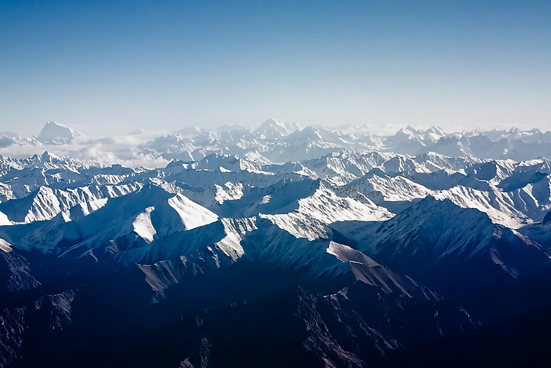
Mountains of Eurasia
Eurasia, the combination of both the European and Asian continents, makes up around 36.2% of the Earth’s surface and 33% of the area here is mountainous.
One of the most well-known mountain ranges located here is the Himalayas, which covers area throughout India, China, Nepal, Pakistan, and Bhutan. Across this area lives a population of approximately 52.7 million individuals. The Himalaya mountain range is made up of more than 50 individual mountain peaks. These peaks run in a northwest to southeast direction, over a distance of around 1,500 miles in length. It measures as wide as 220 miles in some locations and 93 miles in others. Additionally, it is the point of origin for several rivers, including 3 major ones: the Ganges, the Tsangpo-Brahmaputra, and the Indus. The Himalaya mountain range is also home to the highest peak in the world, Mount Everest. Mount Everest reaches 29,029 feet above sea level and forms the border between Tibet and Nepal.
Another widely recognized mountain range in Eurasia is the Ural mountains, which begin in the western central region of Russia. This mountain range is often considered the physical boundary between the European and Asian continents. The Urals stretch in a north to south direction, covering around 1,600 miles in length, making up a large portion of the northern border of Kazakhstan. The highest peak here is Mount Narodnaya, which stands at 6,217 feet above sea level.
Mountains of North America
North America makes up around 16.5% of the Earth’s surface and 24% of its area comprises of mountainous landscapes.
One of the largest mountain ranges in North America is the Rocky Mountains, which begin in the northwestern region of Canada and extend over 3,000 miles to the southwestern region of the US. The Rockies measure around 300 miles at its widest location and only 70 miles at its most narrow. Its highest peak is Mount Elbert, which is located in the US state of Colorado and reaches 14,440 feet above sea level. This mountain range marks the Continental Divide of the Americas. To the west of this line, rivers flow into the Pacific Ocean and to the east of this line, rivers flow into the Atlantic Ocean.
The Appalachian mountains makeup one of the oldest mountain ranges here and were formed around 480 million years ago. This mountain range runs along the eastern region of North America, beginning in the southeastern region of Canada and ending in the southeastern region of the US. This range extends around 1,500 miles in total. Its highest peak is Mount Mitchell, which is located in the US state of North Carolina and stands at 6,684 feet above sea level.
Mountains of South America
South America makes up around 12% of the Earth’s surface and is 19% of its area is covered by mountains.
The longest mountain range in the world is located in South America, the Andes mountains. This mountain range runs approximately 4,300 miles along the western region of the continent, crossing through Ecuador, Peru, Chile, Bolivia, Argentina, Colombia, and Venezuela. It measures around 430 miles across at its widest point and around 120 miles at its most narrow. The Andes mountain range is so extensive that it can be separated into 3 climatic zones: the Dry Andes, the Wet Andes, and the Tropical Andes. Additionally, it is home to a number of plateaus, including the Altiplano, which is the second highest in the world. The highest peak in the Andes is Mount Aconcagua, which is located in Argentina and stands at 22,838 feet above sea level.
Mountains of Africa
Africa makes up around 20.4% of Earth’s total land area and 14% of the area of Africa is mountainous.
The Atlas mountains are one of the most well-known mountain ranges in this continent and are located in the northern region of Africa. This mountain range creates the physical border between the Mediterranean coast and the Saharan desert. It stretches around 1,600 miles across 3 countries: Algeria, Tunisia, and Morocco. The Atlas mountains are home to a number of mineral deposits as well as a significant number of endangered plant and animal species. Additionally, some areas of this mountainous landscape are inhabited by humans. Most of these individuals identify as Berbers, an indigenous group. The tallest peak in this mountain range is Mount Toubkal, which is located in Morocco and stands at 13,671 feet above sea level.


