Erosion Landforms: What Is A Lavaka?
What is a Lavaka?
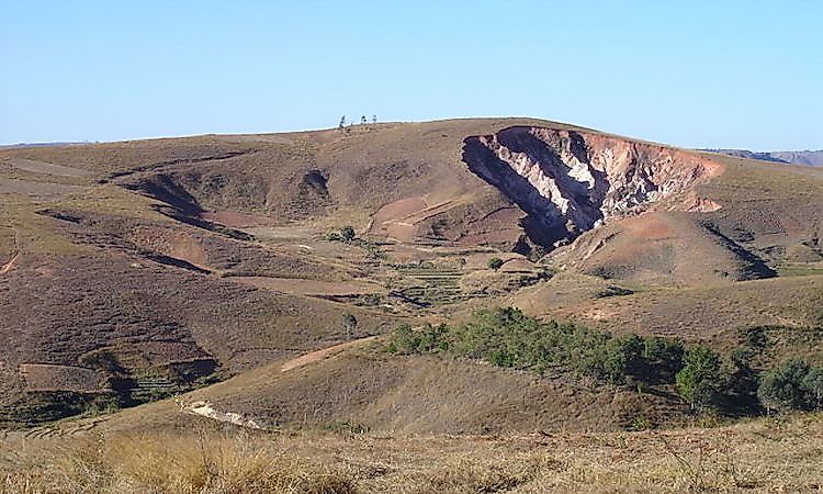
Lavaka is a type of erosional feature common in Madagascar and it is a hole etched out on the slopes of a hill by weathering of rocks. Lavaka is a Malagasy word which translates to hole or gully, and it has gained international acceptance as the reference to the landform. Lavaka are also found in the Democratic Republic of Congo and South Africa. Other countries where similar landforms exist include the US, Swaziland, and Brazil.
Lavakas are mostly formed through natural processes, but human activities including road development and deforestation can contribute to the process. The landforms develop on steep and convex slopes where crystalline rock containing weatherable minerals forms the bedrock. The landforms mainly occur in the Central Highlands of Madagascar which experience a monsoonal climate marked by an extended torrential rainy season interrupted by a long dry season. On the bedrock lies a 10-meter thick layer of saprolite which is overlain by a one-meter thick layer of laterites. The laterites are hard and highly oxidized. The regions where Lavaka landforms are common experience a significantly low earthquake activity.
Formation Of A Lavaka
Lavakas are formed through groundwater sapping, an erosion process which leads to the chemical and physical weathering of rocks. When the bedrock becomes water-logged, the layer of saprolite and laterite liquefies and collapses leaving behind tear-drop shaped gullies. Several factors act as controls to this process namely the slope of the region, the hydraulic conductivity of the elements present in the saprolite, and the seismic activity in the area. The average size of Lavakas in Madagascar is 40 meters wide, 80 meters long and 15 meters deep. The landforms characterize the highlands in the country and appear as collapsed hillsides and deep cuts in the valleys.
Man-made Causes Of Lavaka Formation
Some human activities have been faulted for contributing to lavaka formation. These activities range from deforestation, habitat degradation, overgrazing, road, and infrastructure development, grassland burning, and poor agricultural practices. Climate change is another concern due to unpredictable rain and drought, as well as floods. There has been a call for better land management practices to reduce the occurrence of lavakas and their subsequent negative consequences on agriculture and infrastructure.
Negative Effects Of Lavaka Formation
Madagascar’s landscape is characterized by steep and mountainous areas which pose challenges in farming. The creation process of lavakas further aggravates the situation by channeling debris flow to the agricultural regions in the valleys. The debris destroys the crop, pasture lands as well as villages. The formation process also negatively impacts on infrastructure, especially roads.
Positive Effects Of Lavakas
Lavakas have promoted the country’s tourism however due to their uniqueness and spectacular scenery. Mature lavakas have provided farmers with agricultural opportunities despite the devastating effects of their formation process. Farmers have resorted to practicing agroforestry in the lavaka or at its base. Mature lavakas serve to channel water and nutrients in their crevices as well as at the base. These conditions are ideal for agriculture and have promoted the establishment of agricultural settlements. The farmers also employ terrace farming methods to reduce the strain on the erosion-prone soil and allow water to flow freely down the slopes.


