What Is The Indian Subcontinent?
- A subcontinent is a part of a continent that is politically and/or geographically separate from the rest of the continent.
- Geographically, the Indian Subcontinent consists of the peninsular part of present-day India, south of the Himalayas, on the Indian tectonic plate.
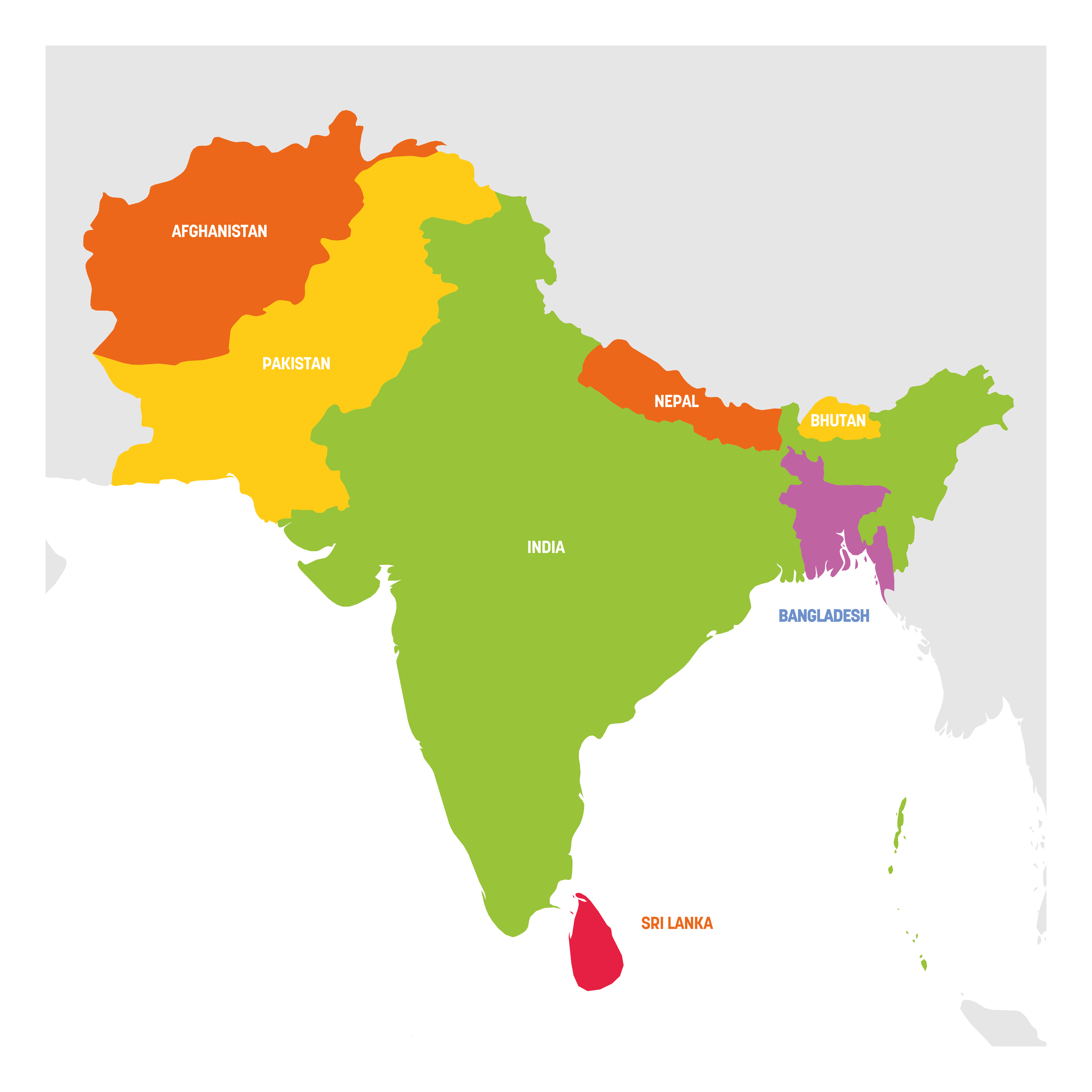
- From a political perspective, the Indian subcontinent consists of at least 7 countries: India, Pakistan, Nepal, Bhutan, Bangladesh, Sri Lanka, and the Maldives.
- Some consider Afghanistan to be part of the Indian Subcontinent.
- The people of the Indian Subcontinent have shared ethnic, linguistic, cultural, and historical ties.
The Indian subcontinent is a southern subregion of Asia covering roughly 5.2 million square kilometers (2 million square miles) and home to approximately 2.04 billion people, or about a quarter of the global population. The region sits on the Indian tectonic plate, with the Himalayas to the north separating it from the rest of the Asian landmass and the Indian Ocean defining its southern edge. The subcontinent's geographic distinctness reflects a combination of physical geography, deep cultural and religious history, and the political legacy of British colonial rule. The term Indian subcontinent is often used interchangeably with the related term South Asia, though some analysts use the two with slightly different boundaries.
Defining the Indian Subcontinent

A subcontinent is a part of a continent that is geographically or politically distinct from the rest of the continent, and the Indian subcontinent qualifies on both grounds. Geographically, the region sits on the Indian tectonic plate, which split from the supercontinent Gondwana approximately 140 million years ago and drifted northward before colliding with the Eurasian Plate about 50 million years ago. That collision is the geological event responsible for raising the Himalayas, and it continues today, with the Indian Plate still pushing into Asia at about 4 to 5 centimeters per year. The Indian Plate also includes parts of southern China and the Indian Ocean floor, so the geographic boundary of the subcontinent is not strictly identical to the tectonic boundary.
Politically and culturally, the subcontinent is defined by shared history, religion, and language. Most of the modern countries of the region were once governed as part of British India (1858-1947), and the partition of that empire in 1947 created the political map that still organizes the region today. Britannica's standard definition includes at least India, Pakistan, and Bangladesh, with Nepal, Bhutan, Sri Lanka, the Maldives, and sometimes Afghanistan added depending on the writer.
The Physical Landscape
Three major physiographic regions structure the Indian subcontinent. The Himalayas to the north form the world's highest mountain range, extending about 2,400 kilometers along the northern border and including Mount Everest (8,849 meters), Kanchenjunga (8,586 meters), and several other peaks above 8,000 meters. The range acts as a climatic barrier, blocking cold central Asian winds from reaching the subcontinent and trapping the moisture-laden summer monsoon winds against the mountains, which is what makes the region's agricultural plains so productive.
South of the Himalayas, the Indo-Gangetic Plain extends roughly 2,400 kilometers across northern India, Pakistan, and Bangladesh, covering about 700,000 square kilometers and forming the most extensive uninterrupted alluvial plain in the world. The plain is built up of sediments carried down by three of Asia's great river systems: the Indus, which rises in Tibet and flows southwest through Pakistan to the Arabian Sea; the Ganges, which rises in the Gangotri Glacier in the Indian state of Uttarakhand and flows southeast across northern India and Bangladesh to the Bay of Bengal; and the Brahmaputra, which rises on the northern slopes of the Himalayas in Tibet, loops east, and joins the Ganges in Bangladesh to form one of the world's largest river deltas.
The southern peninsula, the Deccan Plateau, occupies most of central and southern India. It is bounded on the west by the Western Ghats and on the east by the Eastern Ghats, two mountain ranges that meet at the southern tip of the peninsula. Sri Lanka sits offshore in the Indian Ocean, separated from the peninsula by the shallow Palk Strait.
The Countries of the Subcontinent

Seven countries are universally counted as part of the Indian subcontinent, with Afghanistan sometimes added as an eighth. India is by far the largest in both area and population, covering 3.29 million square kilometers (the seventh largest country in the world by area) and home to roughly 1.45 billion people as of 2025, making it the world's most populous country since it overtook China in April 2023.
Pakistan occupies about 796,000 square kilometers in the northwest and has a population of approximately 240 million. Bangladesh, carved out of the eastern portion of British India and then out of Pakistan, covers only about 148,000 square kilometers but is home to roughly 170 million people, giving it one of the highest population densities of any large country in the world. Sri Lanka, an island nation off the southeastern coast of India, has an area of about 65,610 square kilometers and a population of approximately 22 million. Nepal, sandwiched between India and Tibet, covers 147,000 square kilometers and has a population near 30 million; Bhutan, also in the Himalayas, is much smaller at about 38,400 square kilometers and a population just under one million. The Maldives, a chain of low-lying coral atolls in the Indian Ocean southwest of India, covers only 298 square kilometers of land and is home to approximately 520,000 people, making it the smallest country in Asia by both area and population.
Borderline Cases: Afghanistan, Tibet, and Myanmar
Three regions are sometimes counted as part of the Indian subcontinent and sometimes not. Afghanistan is included by some geographers and excluded by others. Its political and security history is closely intertwined with Pakistan's, particularly since the Soviet invasion in 1979 and the subsequent decades of war that drove millions of Afghan refugees into Pakistan. The Pashtun ethnic group spans the Afghanistan-Pakistan border, and the two countries share Islam as the dominant religion. Geographically, however, Afghanistan sits west of the high passes through the Hindu Kush, which separate the Indian Plate from the rest of Asia, and most geographic definitions place it in Central Asia rather than South Asia.
Tibet, on the other hand, is culturally and linguistically closer to the subcontinent (particularly Bhutan, Nepal, and northern India) than to the rest of China. Tibetan Buddhism is the dominant religion in Bhutan and Mongolia and is influential in Nepal and parts of Indian Himalayan states such as Sikkim and Ladakh. But Tibet has been politically part of the People's Republic of China since 1950, and contemporary writers therefore do not place it in the Indian subcontinent. Myanmar (formerly Burma) was governed as part of British India from 1885 to 1937 but is generally excluded from the subcontinent today because its language, religion, and culture are more closely tied to Southeast Asia than to South Asia.
A Cradle of World Religions

Four of the world's major religions originated in the Indian subcontinent. Hinduism, the oldest of the four, has no single founder and developed gradually over several thousand years, with its earliest texts (the Vedas) composed in northwestern India between roughly 1500 and 1200 BCE. It is the dominant religion of India (about 80 percent of the population) and Nepal (about 81 percent), and it has roughly 1.2 billion followers worldwide, almost all of them in or descended from the subcontinent.
Buddhism was founded in northern India around the 5th century BCE by Siddhartha Gautama, who attained enlightenment under the Bodhi Tree at Bodh Gaya in modern Bihar. Although Buddhism is now a minority religion in India itself, it is the dominant religion of Bhutan and Sri Lanka and has hundreds of millions of followers across East and Southeast Asia. Jainism, an ascetic religion that emphasizes non-violence, was also founded in northern India around the 6th century BCE, traditionally associated with the teacher Mahavira. Sikhism, the youngest of the four, was founded in the Punjab region in the 15th century CE by Guru Nanak and combines elements of Hindu and Islamic thought; it has approximately 25 to 30 million followers worldwide, concentrated in Indian Punjab.
Islam, which arrived in the subcontinent through Arab traders in the 7th century CE and through Central Asian invasions beginning in the 11th century, is now the dominant religion of Pakistan (about 97 percent), Bangladesh (about 91 percent), and the Maldives (about 99 percent), and the second-largest religion in India by total numbers (about 200 million Indian Muslims, the third-largest Muslim population of any country in the world).
Ancient Civilizations and Imperial History
The Indus Valley Civilization, one of the world's earliest urban civilizations, flourished in the northwestern subcontinent between approximately 2600 and 1900 BCE. Its largest cities, Mohenjo-daro and Harappa (both in modern Pakistan), had populations of tens of thousands and featured planned street grids, sophisticated drainage and sewage systems, and standardized weights and measures. The civilization's script remains undeciphered, and its decline around 1900 BCE is still debated by archaeologists.
Successive empires shaped the region in the centuries that followed. The Mauryan Empire (about 322 to 185 BCE), founded by Chandragupta Maurya and reaching its peak under his grandson Ashoka, unified most of the subcontinent for the first time and spread Buddhism across Asia through royal patronage. The Gupta Empire (about 320 to 550 CE) is often called India's classical age, producing major advances in mathematics (including the concept of zero), astronomy, and Sanskrit literature. The Delhi Sultanate (1206 to 1526) and then the Mughal Empire (1526 to 1857) governed much of northern India under Muslim rulers, leaving behind major architectural works such as the Taj Mahal, completed in 1653 under the emperor Shah Jahan.
European involvement began with Portuguese traders arriving in 1498, but the dominant colonial power eventually became Britain. The English East India Company gradually took political control of much of India in the 18th and early 19th centuries, and after the Indian Rebellion of 1857 the British Crown assumed direct rule, governing the territory as British India from 1858 until independence in 1947.
Partition and Modern Politics

The 1947 partition of British India remains the defining political event in the modern history of the subcontinent. As independence approached, the Indian National Congress, led by figures including Mahatma Gandhi and Jawaharlal Nehru, sought a single unified independent country. The All-India Muslim League, led by Muhammad Ali Jinnah, argued for a separate Muslim state. In the end, the British transferred power on August 14-15, 1947 to two new countries: a Hindu-majority India and a Muslim-majority Pakistan. The latter was created in two non-contiguous halves, West Pakistan (modern Pakistan) and East Pakistan (modern Bangladesh), separated by more than 1,600 kilometers of Indian territory.
The partition was accompanied by one of the largest forced migrations in human history, with an estimated 14 to 18 million people displaced across the new borders and between several hundred thousand and two million killed in communal violence. East Pakistan eventually broke away from West Pakistan after the Bangladesh Liberation War of 1971, becoming the independent country of Bangladesh in December of that year following Indian military intervention.

India and Pakistan have fought five wars: the First Kashmir War (1947-48), the Second Kashmir War (1965), the Bangladesh Liberation War (1971), the Kargil War (1999), and a brief but intense four-day conflict in May 2025. All have centered on or been complicated by the dispute over Kashmir, which both countries claim in full but each controls only part of. Both countries became declared nuclear powers in May 1998, when each conducted underground nuclear test series within weeks of the other. The most recent escalation, in May 2025, followed a militant attack at Pahalgam in Indian-administered Kashmir on April 22 of that year that killed 26 people, mostly Hindu tourists; India responded with missile strikes deep into Pakistan in an operation it called Sindoor, and a ceasefire was reached on May 10. The current prime minister of Pakistan, Shehbaz Sharif, has held office since March 2024.
Common Threads Across the Subcontinent

Beyond the political divisions, the subcontinent is bound together by overlapping languages, food traditions, music, and one almost universal popular obsession: cricket. The British introduced the sport in the 19th century, and India, Pakistan, Bangladesh, and Sri Lanka are all now major Test-playing nations. India won the men's Cricket World Cup in 1983 and 2011 and dominates the commercial side of the sport through the Indian Premier League. Matches between India and Pakistan draw television audiences in the hundreds of millions and are the most-watched sporting events in the region.
The languages of the subcontinent belong primarily to two unrelated families. Indo-Aryan languages, descended from Sanskrit and spoken by roughly 1.3 billion people, include Hindi, Bengali, Urdu, Punjabi, Marathi, Gujarati, and Nepali. Dravidian languages, with roughly 250 million speakers concentrated in southern India and Sri Lanka, include Tamil, Telugu, Kannada, and Malayalam. Hindi (written in the Devanagari script) and Urdu (written in a Perso-Arabic script) are mutually intelligible in spoken form but diverged in literary tradition and script, and their relationship is the most prominent example of the political complications of language in the region. Bengali is spoken in both Bangladesh and the Indian state of West Bengal; Punjabi is spoken on both sides of the India-Pakistan border. These shared languages support a steady flow of music, film, and television across borders, with the Hindi-language film industry based in Mumbai (commonly called Bollywood) producing more feature films annually than Hollywood and reaching audiences across the entire subcontinent.
Why the Subcontinent Matters
The Indian subcontinent is home to roughly one in four humans alive today, accounts for a growing share of the global economy (South Asia's combined GDP exceeded $5 trillion in 2024), and includes two nuclear-armed states whose ongoing dispute is one of the most studied geopolitical flashpoints in the world. The region's geographic distinctness, anchored by the Himalayas and the Indian Plate, has shaped its history for thousands of years; the cultural and religious traditions developed here have spread across Asia and, through diaspora communities, much of the world. Understanding what the Indian subcontinent is, and how its physical, political, and cultural geography fit together, is increasingly necessary for understanding the twenty-first century world.