Where is Pike County, Pennsylvania?
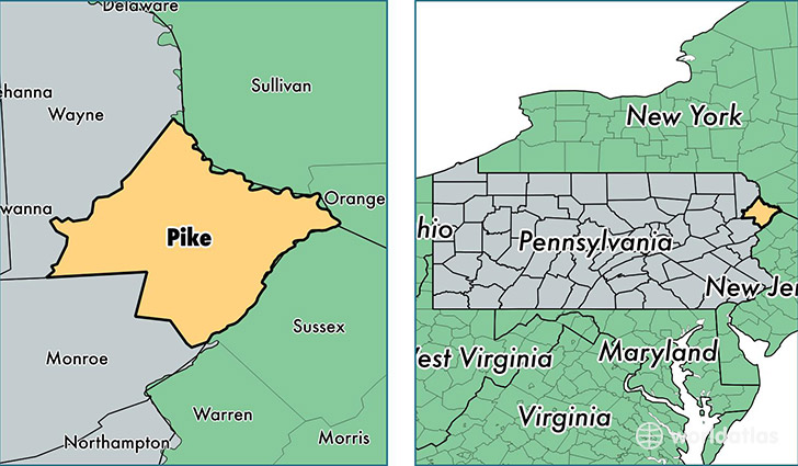
Pike County is a county equivalent area found in Pennsylvania, USA. The county government of Pike is found in the county seat of Milford.
With a total 1,468.13 sq. km of land and water area, Pike County, Pennsylvania is the 1944th largest county equivalent area in the United States. Home to 56,191 people, Pike County has a total 38408 households earning 59340 on average per year.
Pike County, Pennsylvania offers the following attractions to visitors: DWG NRA, DWG NRA Bushkill River Access, DWG NRA Commercial Gatehouse Southbound, DWG NRA Dingmans Falls Visitor Center, DWG NRA Dingmans River Access, DWG NRA Info Station Bushkill Meeting Ctr, DWG NRA Maintainence Yard, DWG NRA Milford Beach, DWG NRA PEEC (Pocono Environmental Ed. Ctr.), DWG NRA Ranger Office, DWG NRA Southbound Entrance, DWG NRA Store & Campground, DWG NRA Valley View Group Camp Ground
Pike County, Pennsylvania - Quick Facts
| FIPS Code | 42103 |
| Area Codes | 570 |
| Time Zone | EST |
| Major Cities | Milford (population: 14,452), Bushkill (population: 9,634), Dingmans Ferry (population: 7,695), Greentown (population: 4,488), Matamoras (population: 4,048), Shohola (population: 2,992), Greeley (population: 1,342), Tafton (population: 1,183), Lackawaxen (population: 788), Tamiment (population: 740) |
| Land Area | 21,695 sq miles |
| Water Area | 545 sq miles |
| Household Income | $59,340 |
| Housing Units | 38,408 |
| Median Home Value | $193,100 |
| High School Grads | 91% of population |
| Holders of Bachelors Degrees | 23% of population |
| Retail Spending | $6,847 per capita |
| Food & Accomodation Sales | $75,810 per capita |