Hudson Bay
A bay is defined as a depressed, coastal water body that is in turn directly connected to another main water body such as a lake, ocean, or a larger bay. They can be formed in different ways and vary in size depending upon the nature of their formation. Situated in northeastern Canada, the Hudson Bay is a large body of saltwater and the 2nd largest bay on the planet, after the Bay of Bengal.
Covering a surface area of 1,230,000 km2, the Hudson Bay is also the largest inland (epicontinental) sea in the world. The sea’s drainage area is even larger and covers an area of 3,861,400 km2. The Hudson Bay is approximately 1,370 km long and 1,050 km wide and is relatively shallow, with an average depth of about 100 m.
The Hudson Bay is named for the Dutch explorer Sir Henry Hudson who explored these waters in 1610 while looking for a Northwest Passage to Asia.
Where Is The Hudson Bay?

The Hudson Bay has the longest shoreline of any bay in North America and indents deeply into east-central Canada. It is bounded by the territory of Nunavut in the north and west; Manitoba and Ontario in the south and Quebec in the east. In the northeast, it is connected with the Atlantic Ocean through the Hudson Strait; while in the north, it is connected with the Arctic Ocean through the Foxe Channel and the Fury and Hecla Strait. James Bay is the southern extension of the Hudson Bay, situated between northern Ontario and Quebec.
The bay lies in a large saucer-shaped basin and occupies the southernmost part of the marsh-ridden Hudson Bay Lowlands, which is fed by the lake waters and numerous turbulent rivers. The large drainage basin of the Hudson Bay includes parts of the Canadian provinces of Manitoba, Ontario, Quebec, Alberta, and Saskatchewan; the Canadian territories of Northwest Territories and Nunavut; and some smaller parts of the US states of Montana, Minnesota, North Dakota and South Dakota.
The Climate Of The Hudson Bay

The Hudson Bay region faces a harsh continental climate and has very low average temperatures throughout the year. During January and February, the bay is covered with floating ice sheets, and the temperature during this time averages -29 °C. The ice starts to melt during May and rapidly disappears during mid-June. The bay is often covered with clouds and fog, which is more frequent during June, July, and August. The temperature during July averages only 8 °C. Due to the influx of freshwater, the surface water temperature rises to 10 °C in July and August. During October and November, the bay waters evaporate, bringing much rain and snow to the region. Strong winds and snowstorms occur during December.
Islands In The Hudson Bay
There are several scattered islands in the Hudson Bay situated mostly in the southeastern part and also in the James Bay. Baffin Island, the largest island in Canada, is situated at the entrance of the bay while the Sleepers, Ottawa, Nastapoka, and Belcher island groups are located in the east. The Mansel, Coats, and Southampton islands are situated at the northern end of the bay. The islands within James Bay, as well as the Belcher Islands in Hudson Bay, are all considered a part of Canada’s Nunavut Territory.
Numerous large and small rivers drain into the Hudson Bay. Some of these rivers include Churchill, Eastmain, Grande, Nelson, Severn, and Winisk.
Marine Life And Protected Areas
The Hudson Bay supports diverse marine and cold-water coastal ecosystems. The Hudson Bay marine ecosystem comprises varied aquatic and coastal habitats that host several Arctic and sub-Arctic species throughout the year.
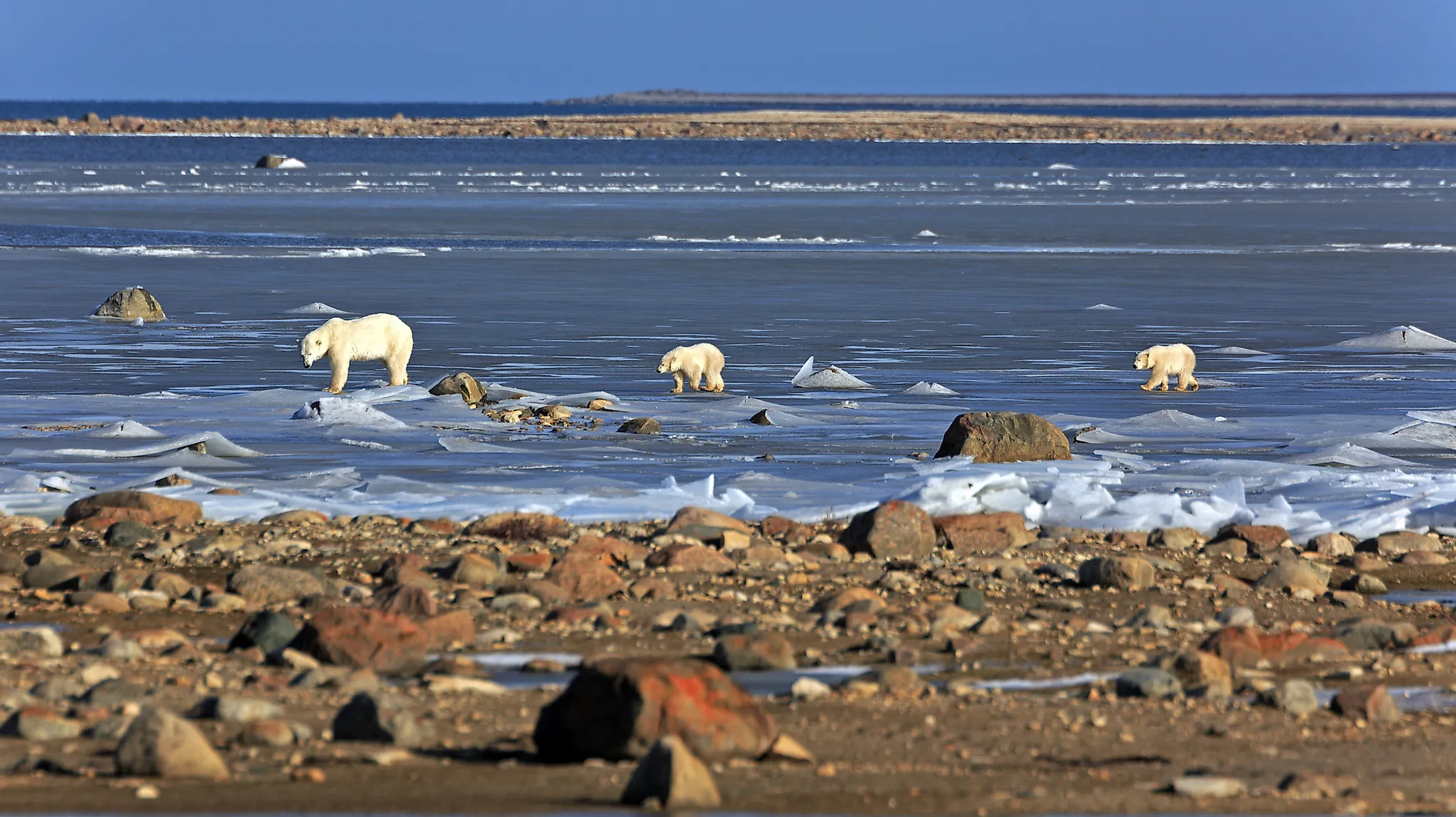
Numerous small crustaceans occupy the surface waters of the bay that forms a rich food source for sea urchins, mollusks, starfishes, and other invertebrates living at the bottom of the bay. The numerous estuaries and rivers of the bay provide habitat and spawning grounds for fishes like salmon, Arctic char, polar plaice, halibut, and cod along with freshwater fishes. Several walruses, dolphins, and killer whales are found in the northern part of the bay. The floating sea ice supports the polar bears, Arctic foxes, and seals. Different types of seals like ringed seals, harbor seals, and bearded seals reside in the bay throughout the year, while the hooded and harp seals seasonally visit the bay.

About 130 avian species including waterfowl, raptors, and waders migrate to the Hudson Bay during the summer months. Out of these 130 bird species, 100 of them find breeding zones on the shore. In addition to this, several ducks, swans, cranes, herons, bitterns, pelicans, falcons, owls, and eagles are also found in the Hudson Bay.

Several migratory marine mammals like the belugas, narwhals, and bowhead frequent the northern parts of the bay. It has been estimated that about 20,000 beluga whales are found during July and August in the estuaries of the Nelson and Churchill rivers. Different herbivorous mammals like muskoxen, caribou, rodents, and some fur-bearing animals are also found in the Hudson Bay.
Covering an area of over 24,000 km2 in the Hudson Bay Lowlands in the Canadian province of Ontario is The Polar Bear Provincial Park. Established in 1970, this park was created to protect the fragile tundra habitat that serves as a home for the polar bears.
Brief History
In 1578, Martin Frobisher mistakenly sailed into the Hudson Strait, but it was in 1610, that Henry Hudson, became the first known European to brave the dangers of the strait and sail into the Hudson Bay. Sir Hudson was followed by Sit Thomas Button in 1612, Robert Bylot, Luke Fox, and Thomas James in 1631. The bay’s western coast, however, was not mapped until the early 1820s and the first detailed bathymetric investigations of the Hudson Bay area were carried out by Canadian researchers only from 1929 to 1931.
Human Settlements

Several Indigenous groups reside in the Hudson Bay region. The area around James Bay is inhabited by the Algonquian group. The Chipewyan groups inhabit the Churchill area, while the Inuit and Cree Indigenous groups are found in the northern and eastern coasts of the Hudson Bay. Some main settlements along the bay include Arviat, Chesterfield Inlet, Coral Harbor, Rankin Inlet, Whale Cove, Churchill, Fort Severn, Fort Albany, and Sanikiluaq. However, the density of the population is very low. The Government of Canada has designated the entire Hudson Bay region as a “mare clausum” (closed area) for conservation purposes.

|
Settlement |
Province/Territory |
Population |
|---|---|---|
|
Rankin Inlet |
Nunavut |
2,842 |
|
Arviat |
Nunavut |
2,657 |
|
Puvirnituq |
Quebec |
1,779 |
|
Inukjuak |
Quebec |
1,757 |
|
Whapmagoostui |
Quebec |
984 |
|
Churchill |
Manitoba |
899 |
|
Coral Harbour |
Nunavut |
891 |
|
Sanikiluaq |
Nunavut |
882 |
|
Kuujjuarapik |
Quebec |
686 |
|
Akulivik |
Quebec |
633 |
|
Umiujaq |
Quebec |
442 |
|
Chesterfield Inlet |
Nunavut |
437 |
|
Whale Cove |
Nunavut |
435 |
|
Fort Severn First Nation |
Ontario |
361 |
Economy
The discovery of the Hudson Bay served as fruitful for the Hudson Bay Company (HBC) by helping them to advance their fur trade business as well as providing an opportunity for different other traders to reach most of the inland destinations in Canada. Fishing and hunting of sea mammals are some of the major local occupations of people residing in the Hudson Bay region. Located in the Canadian province of Manitoba, the Port of Churchill is a privately-owned deep-water port in the Hudson Bay.
|
Feature |
Fact |
|---|---|
|
Max. length |
1,370 km |
|
Max. width |
1,050 km |
|
Surface area |
1,230,000 km2 |
|
Average depth |
100 m |
|
Max. depth |
270 m |