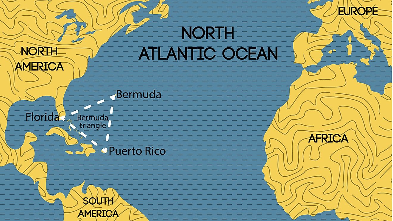
Bermuda Triangle
Also referred to as the Devil’s Triangle, the Bermuda Triangle is a region situated in the western portion of the North Atlantic Ocean. This loosely defined region is the location where approximately more than 20 aircraft and 50 ships disappeared in unclear circumstances.
Though the region’s boundaries are not universally agreed upon, the area has a roughly triangular shape whose apexes are formed by Bermuda, Puerto Rico, and Miami, Florida. The Bermuda Triangle area also happens to be one of the busiest navigational routes in the world.
Several significant disappearances have taken place in the Bermuda Triangle region. Some of these include the USS Cyclops (1918), the Carroll A. Deering schooner (1919), Flight 19 (1945), Star Tiger and Star Ariel (1948 & 1949), Douglas DC-3 (1948), and KC-135 Stratotankers (1963).

Origin
The name “The Deadly Bermuda Triangle” was first used by the American author Vincent Gaddis in 1964 while writing an article about this mysterious region in the American pulp magazine, Argosy. However, the region became famous after the 1974 best-selling book by Charles Berlitz, titled The Bermuda Triangle. In this book, the author discusses several theories regarding the disappearance of airplanes and ships in this region under unexplained circumstances. The author also posits that the region may be a remnant of the mythical city of Atlantis.
Bermuda Triangle Theories

Although several theories exist, most official sources do not recognize the Bermuda Triangle as a mysterious place. However, there are still few proven explanations regarding the mysterious disappearances of the ships and airplanes in this region.
Some sources have attributed most of the disappearances to the unique environmental features of the area. It is believed that the Bermuda Triangle region is one of the few places on earth where magnetic compass point towards the true geographic north. This magnetic anomaly is believed to be largely responsible for navigational errors and subsequent catastrophes in this region. Another popular theory is about the nature of the Gulf Stream. This major surface current is extremely swift and turbulent and can quickly disperse any evidence of a disaster. In addition to this, the unpredictable violent weather of the Caribbean-Atlantic region likely also led to many incidents in the Bermuda Triangle region.
Scientists have also attributed the destruction of ships and airplanes in this region to the pockets of methane hydrates, which are present in large quantities at the bottom of the ocean. Experiments have revealed that the ignition of methane bubbles caused by lightning or an electrical spark can lead to the sinking of ships. However, this theory has also not been completely validated, as according to the United States Geological Survey, there had been no large release of gas hydrates in the Bermuda Triangle region for more than 15,000 years.