Easter Island
Covering a total area of 163.6 km2, Easter Island is a Polynesian island located in the southeastern Pacific Ocean. Named Rapa Nui by its earliest residents, it is one of the most isolated inhabited islands in the world. It is a special Chilean territory situated about 3,540 km to the west of Chile and about 1,900 km to the east of Pitcairn Island.

Geography
Easter Island is a small, triangular-shaped volcanic island. It is about 24 km in length and has a maximum width of about 12 km at its widest point. The island comprises three extinct volcanoes, namely Terevaka, Poike, and Rano Kau. Situated to the north of the island is the Maunga Terevaka volcano, which rises to an elevation of 511 m and is the island’s highest point. Besides the three main volcanoes, there are other lesser volcanic landforms like the Rano Raraku crater, the Puna Pau cinder cone as well as numerous volcanic caves. Surrounding Easter Island, are five small islets: Motu Marotiri, Motu Kao Kao, Motu Iti, Motu Tautara, and Motu Nui. The island has no permanent rivers but contains three crater lakes, namely Rano Aroi, Rano Raraku, and Rano Kau.

UNESCO named Easter Island as a World Heritage Site on March 22, 1996, and major parts of the island have been protected under the Rapa Nui National Park.
The Easter island faces a tropical rainforest climate. It enjoys relatively mild winters with the lowest average temperature being 15 °C in July and August. The months of January to March are the warmest with the highest average temperature being about 28 °C in February. Due to its proximity to an anticyclone area known as the South Pacific High, there are no cyclones and hurricanes on Easter Island.
Flora And Fauna

Paleobotanical studies have revealed that Easter Island was formerly filled with trees, grasses, shrubs, and large palms. Paschalococos disperta palm trees were extensively used by the early island settlers to construct settlements and therefore they have become extinct today. The landscape of the island is mainly covered by ferns, mosses, flowering plants, and grasses while the area surrounding the crater lakes is covered by Totora reeds and a medicinal plant named Polygonum acuminatum, which is part of the knotweed flora family. The islanders now cultivate crops such as bananas, sweet potatoes, and sugarcane to sustain their livelihoods.
Several avian species have been introduced to Easter island including the Chilean tinamou, red junglefowl, chimango caracara, house sparrow, and common diuca finch. Several deep-sea and coastal fishes are found around Easter Island.
Brief History

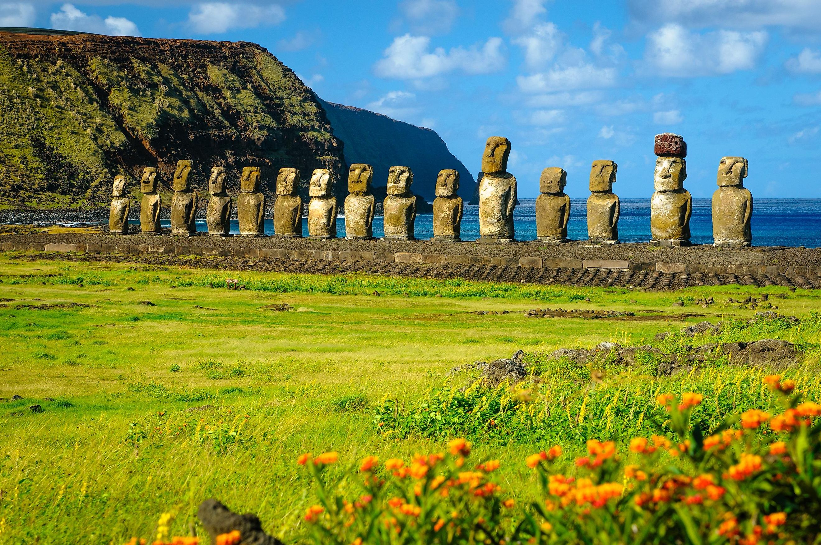
There is no consensus about when the island first became populated, but archaeologists have posited that the early inhabitants of the island arrived at some point between 300-1200 AD, with many claiming around 700-800 especially, from the Marquesas Islands of Polynesia. About 900 giant stone statues that are known as Moai were created by these early inhabitants and have been discovered in different locations throughout the islands. As the population of the island increased, problems between different factions of the population led to extreme lawlessness, destruction, and internal wars.
The Dutch explorer Jacob Roggeveen arrived on the island in 1722 on Easter Sunday and named the island “Easter Island.” In 1770, an expedition sent by the Spanish viceroy of Peru landed on the island. The British navigator James Cook arrived on the island in 1774 and found that almost the entire island population had been decimated due to a civil war and only about 700 men and less than 30 women had survived. In 1862, after the population had managed to partially recover in size, a major slave raid from Peru followed by smallpox and tuberculosis epidemics led to another reduction of the island population. Only about 111 inhabitants lived on the island by 1877. By the late 19th century, the Catholic missionaries who had arrived on the island were converting the remaining island population to Christianity. Easter Island was taken over by Chile in 1888 and leased most of the land to the Williamson-Balfour Company for sheep farming. The surviving Rapanui inhabitants were confined to Hanga Roa, a town on the western coast of the island.


