Maps of Czech Republic

The Czech Republic, a landlocked Central European country, covers an area of 78,866 square kilometers (30,450 sq mi).
In general terms, the Czech Republic is a hilly plateau surrounded by relatively low mountains. The bordering mountain ranges can be observed on the physical map of the Czech Republic above. These include the Carpathian, Ore, Sudetic and the Sumarva mountains.
The highest point is Mt. Snezka in the Sudetic Mountains; it rises to 5,259 ft. (1,603 m). The lowest point in the Czech Republic is on the Elba River at 377 ft (115 m). An upright and an inverted yellow triangle marks the position of these extreme points on the map.
Bohemia, mostly occupying the western half of the country, consists of a low-lying basin drained by the Elbe and Vltava rivers. Moravia, covering the eastern part of the country, is hilly land drained mainly by the Morava River
The Oder River, one of Europe's most significant rivers, rises in the northeast, and flows north to the Baltic Sea.
With a lack of natural lakes, reservoirs are important in the Czech Republic; most are artificial lakes formed in enclosed river valleys and there are over 125 in the country.
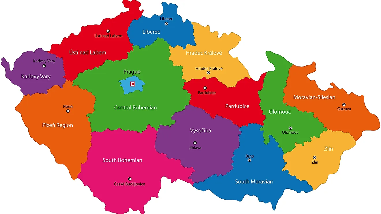
Czech Republic is divided into 13 regions (kraje, sing. kraj) and 1 capital city (hlavni mesto). The regions are: Central Bohemian, South Bohemian, Vysocina, Plzensky, Karlovy Vary, Usti nad Labem, Liberec, Hradec Kralove, Pardubice, Olomouc, Moravian-Silesian, South Moravian and Zlin. Praha (Prague) is the capital city. The regions are divided into districts and further smaller subdivisions of municipalities.
Located in the center of the Bohemian Basin on the Vltava River is, Prague – the capital, and the largest city of Czech Republic. It is also the 13th largest city of EU and one of the finest cities of the European continent. Prague is the major cultural, industrial and economic center of Czech Republic.
Where is Czech Republic?

Czech Republic is a landlocked country located in Central Europe. It is geographically positioned both in the Northern and Eastern hemispheres of the earth. Czech Republic is bordered by 4 nations: by Poland in the north and northeast; by Slovakia in the east; by Austria in the south and by Germany in the west and northwest.
Czech Republic Bordering Countries: Slovakia, Germany, Austria, Poland.
Regional Maps: Map of Europe
Outline Map of Czech Republic

The above blank map represents Czech Republic, a landlocked country strategically located in Central Europe. The above map can be downloaded, printed and used for educational purposes like map-pointing activities and coloring.

The above outline map represents Czech Republic, a landlocked Central European nation. Covering an area of about 78,867 sq. km, it is slightly smaller than the US state of South Carolina.
Key Facts
| Legal Name | Czech Republic |
|---|---|
| Flag |
|
| Capital City | Prague |
| 50 05 N, 14 28 E | |
| Total Area | 78,867.00 km2 |
| Land Area | 77,247.00 km2 |
| Water Area | 1,620.00 km2 |
| Population | 10,669,709 |
| Major Cities |
|
| Currency | Koruny (CZK) |
| GDP | $246.49 Billion |
| GDP Per Capita | $23,101.78 |
This page was last updated on February 24, 2021