English Channel
The Atlantic Ocean is an S-shaped ocean extending from the Arctic to Antarctica. It is located between the Americas to the west and Africa and Europe to the east. The ocean has numerous seas or arms of varying sizes, of which 40 seas span at least 15,000 km2. The English Channel, also known simply as “the Channel,” is the Atlantic’s 30th largest arm, covering approximately 75,000 km2. It is one of the world’s busiest shipping areas, linking southern England, the United Kingdom to northern France.
The current name, “English Channel,” dates back to the 18th century. Before then, the English mostly referred to the waterway as a “Narrow Sea.” However, there was no fixed name for the English Channel in either French or English. The current name may have been derived from the channel’s designation as Engelse Kanaal in Dutch Sea Maps. But the modern Dutch sea map refers to it as Het Kanaal, without the mention of the word “English.”
The English Channel was also known by several other names, including British Sea, British Channel, Oceanus Britannicus (by Ptolemy), and Canalite Anglie ("English Channel" by the Italians). The French refer to the Channel as “la Manche” because of its sleevelike shape.
Where Is The English Channel?
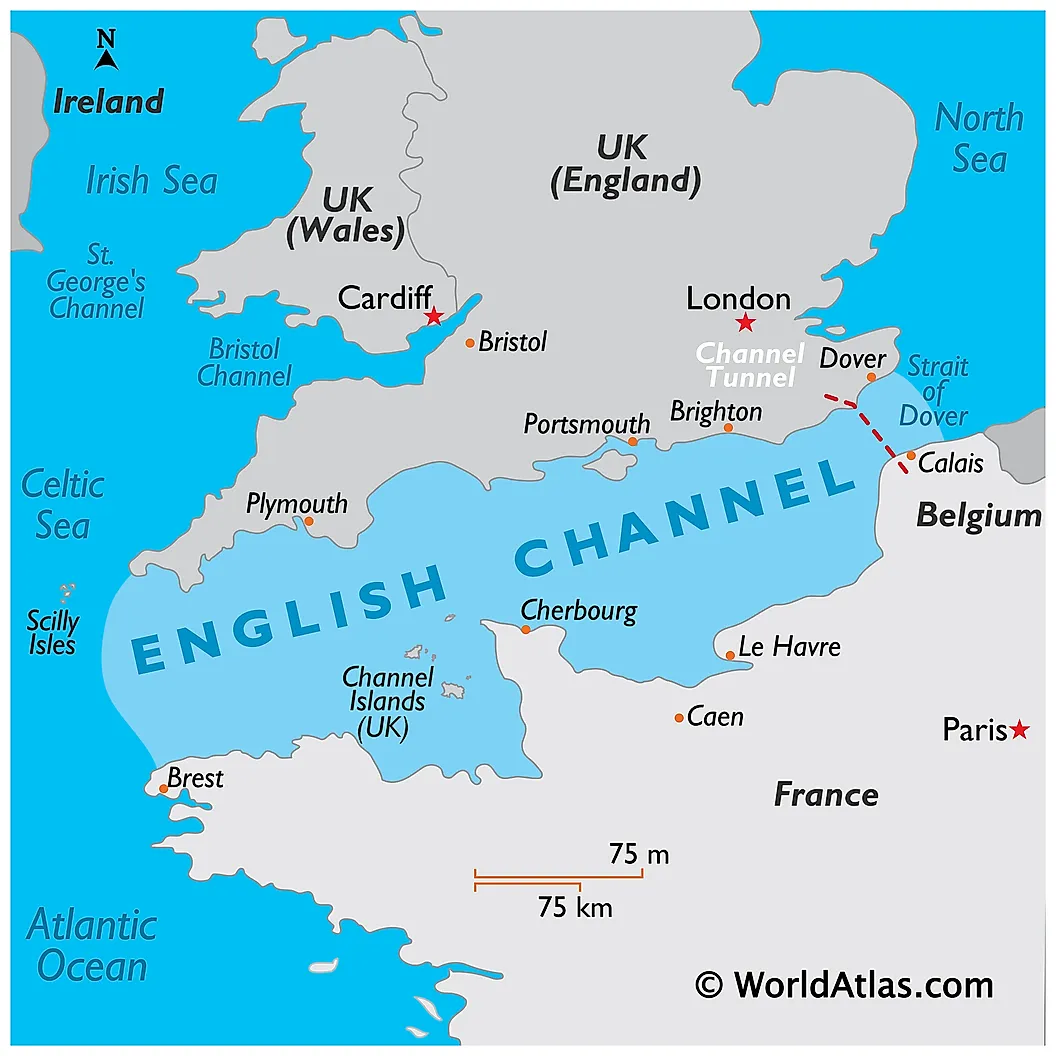
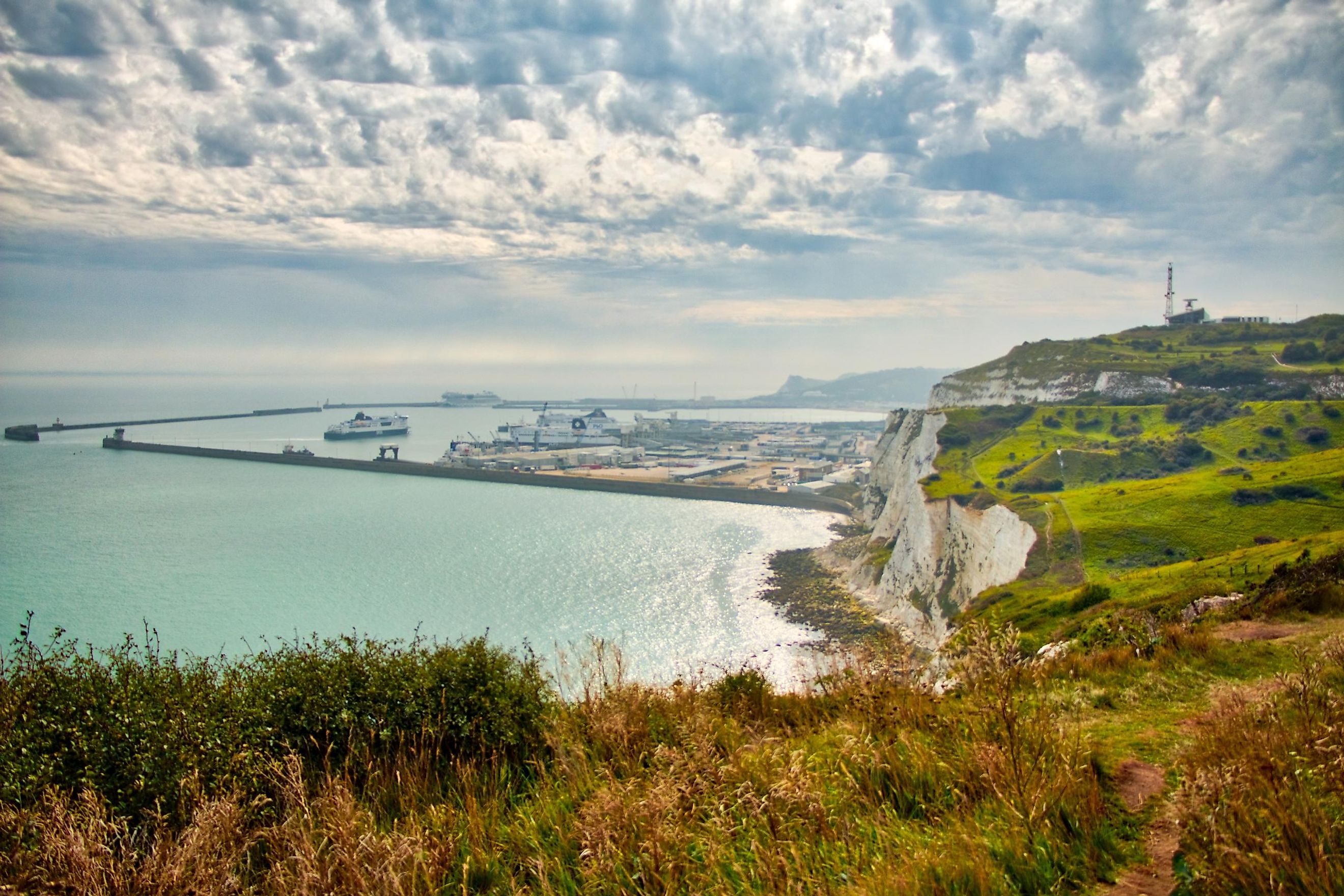
The English Channel is located between the Isle of Great Britain’s southern coast and France’s northern coast and separated from the North Sea on the north by the Strait of Dover. The Strait of Dover is the Channel’s narrowest point at just 34 km2 from Cape Gris-Nez to Dover. The International Hydrographic Organization defines the English Channel’s western limit as a line running from Land’s End, England to Isle Vierge, France. The eastern limit is defined as the North Sea’s southwestern limit. Some towns on the English Channel are Calais, Dover, Isle of Wight, and the Island of Jersey.
Geography

The English Channel is a shallow waterway with a maximum depth of 174 m in the Hurd's Deep underwater valley and an average depth of 63 m. It is 560 km long, with a varying width between 34 and 240 km at the widest point between Saint-Malo Gulf, France and Lyme Bay, England.
Several islands dot the English Channel, with the major ones including the Isle of Wight, Mont Saint-Michel, the Channel Islands, and Chausey. The channel has strong tides ranging from less than one meter to over six meters. The strongest tides are observed on Brittany’s north coast, Channel Islands, and the Cotentin Peninsula’s west coast. The central parts experience semidiurnal tides (two highs and two lows per day), which facilitates the movement of ships at Southampton.
Before the end of the most recent ice age, the British Isles were joined to continental Europe, forming one large mass. Ice covered the entire British Isles and the North Sea, with the sea level being 120 m lower than the current level. As the ice sheet melted, a lake formed in the Doggerland area (North Sea’s southern part). Two catastrophic glacial lake outburst floods, between 450,000 years and 180,000 years ago, breached the ice, resulting in the English Channel formation. The channel was widened further by the erosion of white cliffs, a process that is still ongoing.
Climate
The English Channel’s climate can be described as a temperate maritime climate, with warm summers and cold winters. The channel does not experience an extreme climate, meaning that it can be visited at any time of the year. August is the channel’s warmest month, while the coldest month is January. However, November is the wettest month, with December and January being the driest months. The surface temperature varies, ranging from 45 °F in February to 61 °F in September. Annual precipitation averages 700-1000 mm. Although gales can blow in any direction, they commonly originate from the west or southwest.
Economic Importance

The English Channel is the world’s busiest shipping route, serving over 500 ships daily. It accounts for up to 20% of the global maritime trade and connects the Atlantic Ocean to the North Sea. The channel serves both freight and passenger traffic. The intensity of the ship traffic and frequent accidents have led to the installation of the Dover Traffic Separation Scheme (TSS) in 1967.
Sandy beaches, favorable climate, and availability of ferry services have facilitated tourism growth on the English Channel. Coastal areas such as Deauville (France) and Brighton (England) have fashionable resorts dating back to the 18th and 19th centuries. Channel-hopping is a popular tourism activity that involves channel crossing for leisure.
Channel Crossing
As a narrow waterway, several people have crossed the English Channel using various inventive technologies. However, numerous ferry routes connect England to France, of which the shortest is Dover-Calais. Several people also cross channel using an underground Channel Tunnel. The tunnel passes beneath the channel and connects the two countries by rail. Its construction began in 1974 and was opened to the public in 1994.
The channel was first crossed by air in 1785 by John Jeffries and Jean-Pierre Blanchard using a hot air balloon. A century later, Matthew Webb became the first person to swim across the channel, taking 21 hours and 45 minutes. On August 6, 1926, Gertrude Ederle swam across the channel in 14 hours, breaking the previous record by two hours. She was also the first woman to swim across the channel.