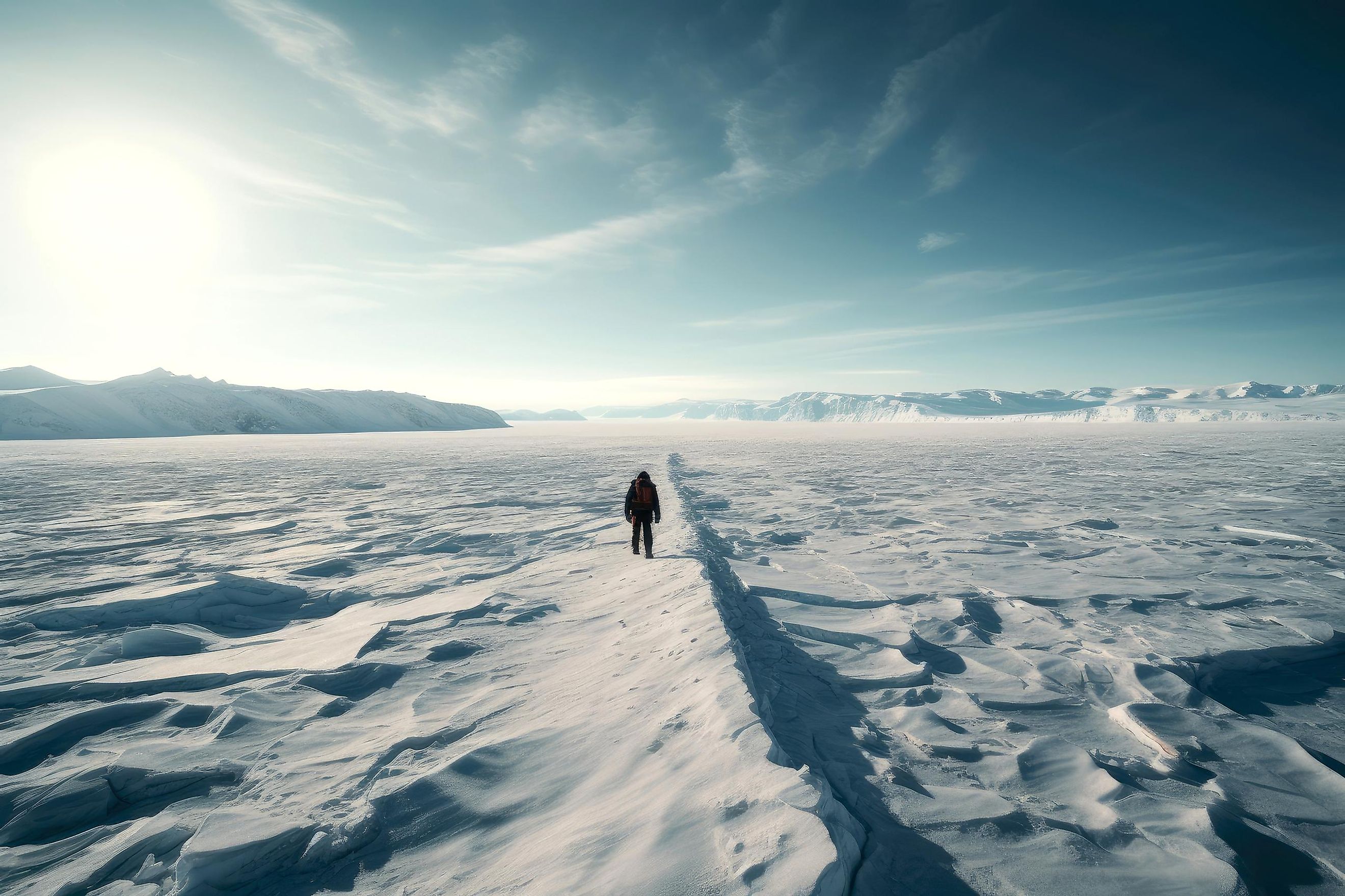
Ice Sheets
Often called continental glaciers, ice sheets refer to a glacial land ice mass that covers a land area of more than 19,000 sq. mi. Currently, ice sheets are present only in Greenland and Antarctica. During the Last Ice Age, a significant portion of North America was covered by the Laurentide Ice Sheet, Northern Europe by the Weichselian Ice Sheet, Western Europe by the Scandinavian Ice Sheet, Northern Asia by the Barents-Kara Ice Sheet, and the Patagonian Ice Sheet covered the southern part of South America.
In several mid-latitude areas, the present landscape is a work of ice sheets that have grown and decayed during the Cenozoic Ice Age and have left their mark in the form of sediments and other glacial landforms. Throughout the planet’s history, this growth and decay of ice sheets several times with fantastic regularity have made them a crucial part of the environmental system of the Blue Planet. Therefore, in these critical times, a thorough knowledge of these ice sheets is essential to understand the mechanism and effects of global climate change.
Geography Of Ice Sheets

Several kilometers thick, ice sheets tend to be somewhat dome-shaped that slope outwards towards the edges from their dome-like centers. Even though the ice sheet is solid, it flows like a liquid over uneven surfaces and encompasses everything in its path, including entire valleys, plains, and mountains. As it moves outwards, the leading edge of the ice sheet fractures due to internal stress and drags over the bedrock, forming crevasses and rifts that cause the calving of icebergs once the ice sheet reaches the ocean. Ice sheets flow downwards to a coastline and onto an ocean surface, forming ice shelves that range in thickness from 330 ft to 3,300 ft. Ice caps are masses of ice found in high-altitude polar and subpolar mountainous regions, covering a land area of less than 19,000 sq. mi and containing many merged glaciers. Since ice caps tend to melt and lose mass quite faster due to the increasing temperatures, they serve as prominent indicators of global warming.
Although the ice sheet’s surface is cold, the bottom of the ice sheet tends to be slightly warmer than the top surface due to compression and geothermal heat. As a result, in places where the bottom of the ice sheet melts, the meltwater greases the interface between the ice and the bedrock, causing the ice above the melted portion to move faster than the rest of the ice sheet. This process creates fast-flowing channels in the ice sheet known as ice streams, which move as fast as 0.6 miles per year and are considered the ice sheet's most dynamic and unstable components.
Distribution Of Ice Sheets
In geological terms, the present-day polar ice sheets are pretty young and reached their maximum size about 18,000 years ago. During the Pleistocene Ice Age, close to one-third of the Earth’s land surface was covered by glaciers, but at present, only one-tenth of the Earth’s land surface is covered by ice sheets. Currently, there are only two ice sheets in the world: the Antarctic Ice Sheet and the Greenland Ice Sheet.
Antarctic Ice Sheet

Initially formed as a small ice cap during the early Oligocene Epoch, the Antarctic ice sheet advanced and retreated many times until the Pliocene Epoch, when it began to occupy almost the entire Antarctica. Covering around 98% of Antarctica, i.e., about 5.4 million sq. mi, this ice sheet is the most enormous single ice mass on Earth, with an average thickness of more than 1.24 mi. The Antarctic ice sheet weighs approximately 24,380,000 gigatonnes and contains 6,400,000 cubic miles of ice. Holding about 61% of the planet’s freshwater and 90% of the Earth’s ice mass, it is estimated that if this expansive ice sheet melts, it will lead to a sea level rise of about 190 ft.
The Transantarctic Mountains divide the Antarctic ice sheet into two unequal divisions: the more extensive East Antarctic Ice Sheet and the smaller West Antarctic Ice Sheet. Although the East Antarctic Ice Sheet occupies a significant portion of the land mass, the bed of the West Antarctic Ice Sheet extends in places over 8,200 ft below sea level. Categorized as a marine-based ice sheet, the West Antarctic Ice Sheet is surrounded by the Ronne-Filchner Ice Shelf, Ross Ice Shelf, and many outlet glaciers that drain into the Amundsen Sea. However, the Antarctic ice sheet is rapidly losing mass, and it is quite unclear as to how much this melting will contribute to a rise in the sea level.
Greenland Ice Sheet

The Greenland Ice Sheet only began forming after the late Pliocene Epoch and developed rapidly after the initial continental glaciation. Covering around 82% of the surface of Greenland, i.e., an area of about 660,000 sq. mi, the Greenland Ice Sheet is the world’s second-largest body of ice, with an average thickness of 0.9 miles, a maximum thickness of 1.9 miles at its thickest point and containing about 696,000 cubic miles of ice. This ice sheet has a maximum length of 1,800 miles in the north-south direction and a maximum width of 680 miles close to its northern margin. It is estimated that if this expansive ice sheet melts, it will lead to a rise in sea levels by 24 ft and substantially change ocean circulation. Besides this massive ice sheet, there are smaller ice caps and glaciers that cover an area between 29,000 and 39,000 sq. mi around the boundary.
However, in comparison to the Antarctic Ice Sheet, the Greenland Ice Sheet is more vulnerable to anthropogenic climate change due to its location in the Arctic region, where it is subjected to polar amplification. Although, during the 21st century, only a tiny fraction of the ice sheet is expected to melt, it is estimated that the entire ice sheet can melt soon if the recent warming patterns are not reversed.
How Do Ice Sheets Form?
The formation process of ice sheets is quite similar to that of the glaciers. Ice sheets are mainly found in areas where the snow that falls during winter does not wholly melt over the summer season. There is an accumulation of snow over several years, which gets harder and compressed after melting. The slightly melted snow gradually changes its texture from soft powder to a block of hard, round ice pellets. The soft grainy snow gets buried as new snow falls, while the hard snow becomes denser and is known as firn. In due course, many firn layers get deposited on each other. When the ice becomes about 165 ft thick, the firn grains fuses to form a massive solid ice mass. At this point, the glacier starts to move under its own weight.
Importance Of Ice Sheets

Ice sheets comprise compressed snow layers over the last 100,000 years and hold one of the most vital records of past climatic conditions. In the previous decades, paleoclimatologists have drilled ice cores up to 2.5 miles deep from ice sheets to sample the layers formed through a yearly snowfall and snow melt cycle. The scientific studies of these ice cores have revealed vital information like temperature changes, precipitation, ocean volume, sea-surface productivity, solar variability, the gas composition of the lower atmosphere, and volcanic eruptions. It is to be noted that studies on subglacial sediments from 0.87 mi below the ice stored since 1966 have revealed that Greenland was entirely ice-free and supported vegetation at least once within the last million years.
Effects Of Global Warming On Ice Sheets

The rapid increase in the planet’s temperatures is melting ice sheets, glaciers, and ice caps. Several studies have revealed that Greenland and Antarctica together lost about 7,560 billion tonnes of ice sheet mass in the last three decades, resulting in a quarter of sea-level rise. Moreover, the rate at which ice sheets lost mass increased to about 372 gigatonnes yearly from 2016 to 2020, in contrast to 105 gigatonnes yearly from 1992 to 1996. Studies have further revealed that this ice mass loss due to the melting of the Greenland ice sheet would continue to exceed the ice mass gained by snowfall accumulation. In addition, the melting ice sheets would significantly alter the Global Ocean Conveyor Belt and affect the marine ecosystems.
Scientists are particularly concerned that if the melting of ice sheets continues at this rapid pace, then by 2100, there will be a rise of around 148 to 272 mm in the global sea level, which would put many low-lying coastal habitats around the world at risk of being flooded. Therefore, continuous monitoring of ice sheets is the need of the hour to predict their behavior on a rapidly warming planet and to make necessary adaptations for associated risks that the coastal settlements around the world will eventually face.