Largest Islands In The Federated States Of Micronesia
The Federated States of Micronesia is an independent island nation composed of four states. The country is made up of 607 Islands scattered in the western Pacific Ocean. The islands cover a combined area of 702 km2. The four states that form the Federated States of Micronesia are Yap, Pohnpei, Chuuk, and Kosrae. Pohnpei is the largest island in the archipelago country and houses Palikir, the national capital.
Largest Islands In The Federated States Of Micronesia
Pohnpei
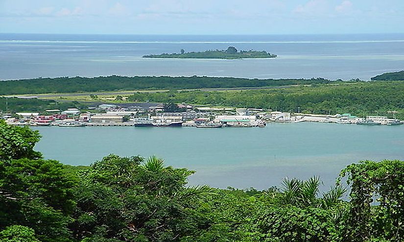
Pohnpei is the biggest island of the Federated States of Micronesia. The capital city of the Federated States of Micronesia is located on the island. It covers an area of 117 square miles (371.6 square km). It is located midway between Manila and Honolulu on the Pacific Ocean. The Island is estimated to have a population of 36,200 people. Pohnpei is an elevated Island compared to its outer islands which occupy lower altitudes. Some of the outer islands are, Pingelap, Pakin, Ant, Ngatik, Oroluk, Nukuoro, and Kapingamarangi. It is a mountainous Island covered by dense rain forests. Mangrove swamps are on the lower shores. The island’s circumference is lined with coral reef. The inhabitants of Pohnpei are Micronesian and a small expatriate community of Americans, Australians, and Europeans. Christian missionaries visited the island in the 19th century, and as a result, the population is predominantly Christian. The Islanders practice subsistent farming and fishing.
Kosrae
Kosrae is the second largest island in the Federated States of Micronesia. It has a land area of 43 square miles (110 square km). The island state has an estimated population of 6,600 residents. Kosrae is covered in dense vegetation and scenic mountains. Scuba divers and hikers regularly visit Kosrae. The island’s natural resources are still intact due to its isolation. Coral reefs surround the island. Government agencies such as the Marine Resources Office help preserve the resources on Kosrae.
Yap
Yap state is composed of many islands that form part of the Federated States of Micronesia. The state covers a land area of 39 square miles (100 square km). It has a population of approximately 11,400 residents. The island is famous for its stone money; large doughnut-like stone disks used as currency in ancient days. Some of the stones had diameters as wide as 4 meters. The stones were extracted from quarries in distant islands and hence they were very scarce. Nowadays, the island uses US Dollars as its currency. Yap residents were among the best navigators in the Pacific Ocean. They relied on wave movements and stars to navigate the ocean. The Yapese had a complex caste system that ranked villages and families. The higher ranks enjoyed privileges that were denied to the lower ranking people. When Germans colonized the island, the caste system was abandoned.
Chuuk
Chuuk is a composed of many small islands in the Pacific Ocean. The islands cover a combined area of 47 square miles (21.5 square km). It is the most populous state of the Federated States of Micronesia with a population of over 50,000 residents. Chuuk is home to Weno, Micronesia’s largest city. Navigation schools in the island offer lessons, and as a result, residents of Chuuk are good navigators. Christianity is the dominant religion although belief in spirits and ancestor worship are still prevalent.
Unexplored Islands Of Micronesia
The numerous islands that form the Federated States of Micronesia are largely unexplored. The areas are isolated and have poor infrastructure thus, and they are difficult to access. In recent years, immigrants from all corners of the world have been moving into the region. The government needs to set rules to preserve the resources within the islands.
Largest Islands In The Federated States Of Micronesia
| Rank | Largest Islands in the Federated States of Micronesia | Land Area |
|---|---|---|
| 1 | Pohnpei | 117 square miles |
| 2 | Kosrae | 43 square miles |
| 3 | Yap | 39 square miles |
| 4 | Weno | 36 square miles |
| 5 | Pingelap | 0.7 square miles |
| 6 | Nukuoro | 0.66 square miles |
| 7 | Satawal | 0.5 square miles |
| 8 | Mokil | 0.43 square miles |
| 9 | Kapingamarangi | 0.4 square miles |
| 10 11 12 | Lelu Pollap Ngatik | 0.39 square miles 0.35 square miles 0.32 square miles |


