Pyrenees Mountains
The Pyrenees are a chain of mountains in southwestern Europe that form a natural border between Spain and France. The tiny landlocked microstate of Andorra is entirely surrounded by the Pyrenees mountains.
Where Are The Pyrenees?

The Pyrenees mountain range extends for about 500 km from the coasts of the Mediterranean Sea in the east to the Bay of Biscay (Atlantic Ocean) in the west. The mountain range separates the rest of continental Europe from the Iberian Peninsula. The western end of the Pyrenees mountain merges with the Cantabrian Mountains located in the northern part of the Iberian Peninsula. Located in the Spanish province of Huesca in the Posets-Maladeta Natural Park is Pico de Aneto, the highest mountain peak in the Pyrenees Mountains. It rises to an elevation of 3,404 m and is also the third-highest mountain in Spain. Politically, the Pyrenees mountain range is separated into two divisions. These are:
The Spanish Pyrenees which form a part of the Spanish provinces of Barcelona, Girona, Gipuzkoa, Huesca, Lleida, and Navarra.
The French Pyrenees which form a part of the French departments of Ariége, Aude, Haute-Garonne, Hautes-Pyrénées, Pyrénées-Orientales and Pyrénées-Atlantiques.
Sandwiched between the French Pyrenees and the Spanish Pyrenees is Andorra, located in the eastern part of the Pyrenees mountain range.
Geography

Physiographically, the Pyrenees Mountain range is divided into three sections. These are the Atlantic (Western) Pyrenees, the Central Pyrenees, and the Eastern Pyrenees. Some of the highest mountain peaks of the Pyrenees Mountain Range including the Pico de Aneto, Pico Posets, and Monte Perdido are located in the Central Pyrenees.
Geological studies have revealed that the Pyrenees Mountains are quite old mountains in comparison to the Alps. The entire Pyrenees Mountain range was formed due to the upwelling of large sedimentary rocks starting about 150 million years ago in the Lower Cretaceous Period and ending in the Eocene Epoch (56 to 34 million years ago). The western part of the Pyrenees mountain range comprises granite peaks that are covered by limestone layers. The eastern part of the mountain range comprises gneissose and granite rocks.
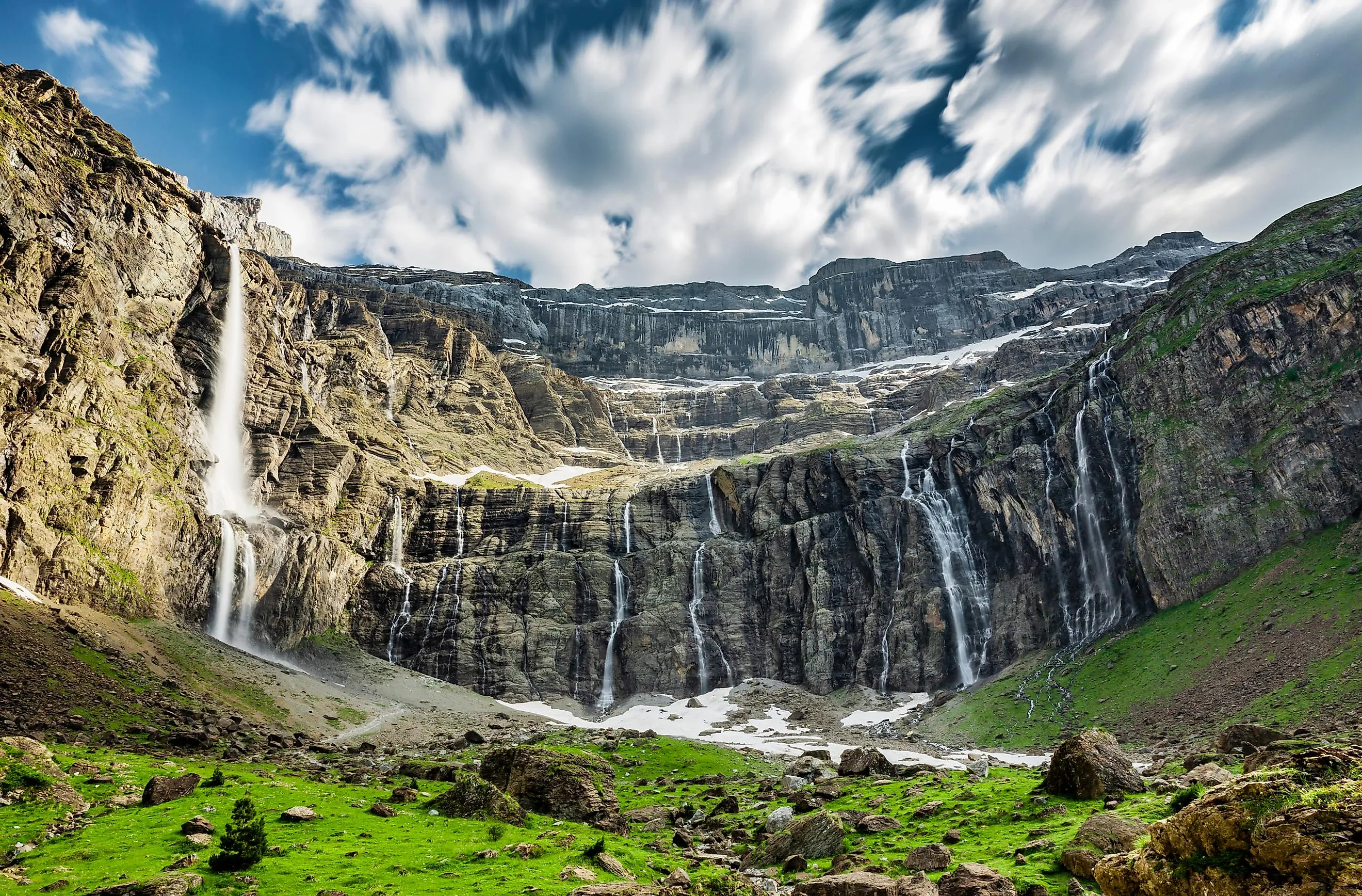
The higher elevations of the mountains have numerous "gaves" which form high waterfalls and many passes that are circled by cirques (hanging valleys). Located in the Cirque de Gavarnie in the Hautes-Pyrénées is the Gavarnie Falls which at 422 m is France’s highest waterfall. Along with Cirque de Gavarnie, Cirque d’Estaubé and Cirque de Troumouse are some significant cirques that are located in the Pyrenees mountain ranges. Some notable passes include Col de la Perche, Col de Puymorens, Col de Somport, Pas de la Casa, Port de la Bonaigua and the Roncevaux Pass. Many sulfurous and saline hot springs are found here. The Western Pyrenees receive more rain and snowfall in comparison to the Eastern Pyrenees. Therefore, some glaciers are found in the Central and Western portions but no such glaciers are found in the Eastern Pyrenees.
Wildlife

The flora on the western side of the Pyrenees mountains is quite similar to that of Central Europe whereas the eastern side has a Mediterranean type of vegetation. The fauna of the Pyrenees mountains includes the endangered brown bears and the endemic Pyrenean desman and Pyrenean brook salamander. In addition to this, several blind insects in the Ariége caves and the highly endangered raptor, the lammergeier (bearded vulture) are also found here. Several nature reserves and national parks are located in the Pyrenees Mountains including the Pyrenees National Park, the Posets-Maladeta Natural Park.