Maps of French Polynesia

Covering a total land area of 4,167 sq.km (1,609 sq mi) and spread over a vast area about the size of Europe, the widely scattered 118 islands and atolls of French Polynesia is an overseas collectivity of France and are divided into 5 island groups: the Austral, Gambier, Marquesas, Society and Tuamotu archipelagos; in the south-central Pacific Ocean. These island groups can be seen on the physical map of French Polynesia above.
Scattered over 965,255 sq. miles (2,500,000 sq.km) of ocean, most of the islands of French Polynesia are volcanic in origin and fringed by coral reefs. Of these islands, the Society archipelago is certainly the most famous. It includes the stunning islands of Bora Bora, Moorea and Tahiti – and like the enchanting Marquesas in the northeast – most are lush, dark green specs of land, volcanic in origin, with jagged-edged peaks jutting boldly into the sky. The tuamotu archipelago (in contrast to the other groups) includes only low-lying coral atolls (78 in all), and of these, only a handful have passable inlets into their central lagoons. Rangiroa, the largest coral atoll in French Polynesia, is famed for its natural beauty, and remains a favorite of travellers from across the globe. The Austral and Gambier islands in the south are lightly populated, as most are still uninhabited. The highest point of French Polynesia is Mont Orohena, which peaks at an elevation of 7,352 ft (2,241m). the lowest point is the Pacific Ocean (0m).
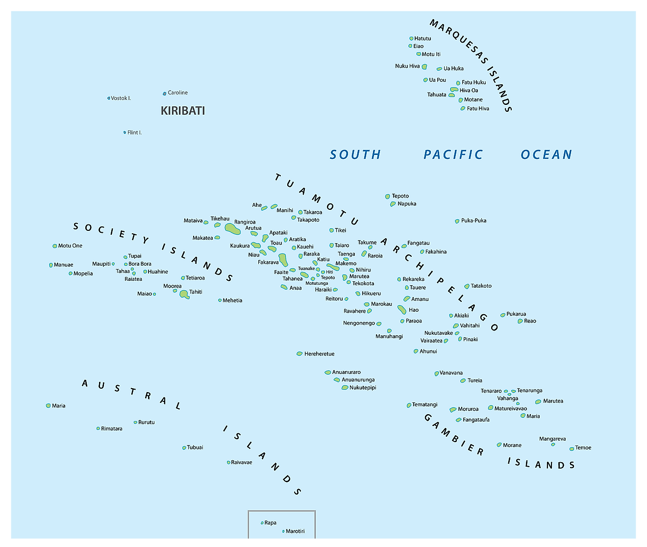
French Polynesia (officially, the collectivity of French Polynesia) is divided into 5 administrative subdivisions (subdivisions administratives, sing. subdivision administrative) and 48 communes. The administrative subdivisions are: lles Australes (Austral Islands), lles du Vent (Windward Islands), lles Marquises (Marquesas Islands), lles Sous-le-Vent (Leeward Islands) and lles Tuamotu-Gambier. [Note: The Leeward Islands and the Windward Islands together make up the Society Islands (lles de la Societe)]. The communes are further subdivided into communes associeés.
Covering a total land area of 4,167 sq.km, French Polynesia is an overseas collectivity of France and comprises of 118 small islands and atolls, scattered across the south-central Pacific Ocean. Out of these 118 islands and atolls, 67 of them are inhabited; among which Tahiti – located in the Society Islands is the most populous. Located on the northwestern coast of Tahiti is, Papeete – the capital, of French Polynesia. It is the administrative, industrial, commercial and financial center of the island territory. Papeete is one of the largest urban centers in the South Pacific region and its excellent harbor serves as the chief port and trading center for transpacific ships. It is also a major tourism hub of the French Polynesia islands. Faaa is the largest city of the island.
Where is French Polynesia?

French Polynesia is an overseas collectivity of France and comprises of 118 small islands and atolls, scattered across the south-central Pacific Ocean. The island groups are geographically scattered over an area of more than 2,000 km in the South Pacific Ocean. They are geographically positioned both in the Eastern and Southern hemispheres of the earth. French Polynesia is located to the east of Brisbane (Australia); to the west of Lima (Peru) and to the south of Hawaii.
Regional Maps: Map of
Outline Map of French Polynesia

The above blank map represents French Polynesia - an overseas collectivity of France comprising of 118 small islands and atolls, scattered across the south-central Pacific Ocean. The above map can be downloaded, printed and used for geography education purposes like map-pointing and coloring activities.

The above outline map represents French Polynesia - an overseas collectivity of France comprising of 118 small islands and atolls, scattered across the south-central Pacific Ocean.
Key Facts
| Legal Name | Overseas Lands of French Polynesia |
|---|---|
| Flag |
|
| Capital City | Papeete (located on Tahiti) |
| 17 32 S, 149 34 W | |
| Total Area | 4,167.00 km2 |
| Land Area | 3,827.00 km2 |
| Water Area | 340.00 km2 |
| Population | 279,287 |
| Currency | Comptoirs Francais du Pacifique francs (XPF) |
This page was last updated on February 25, 2021