Volga River
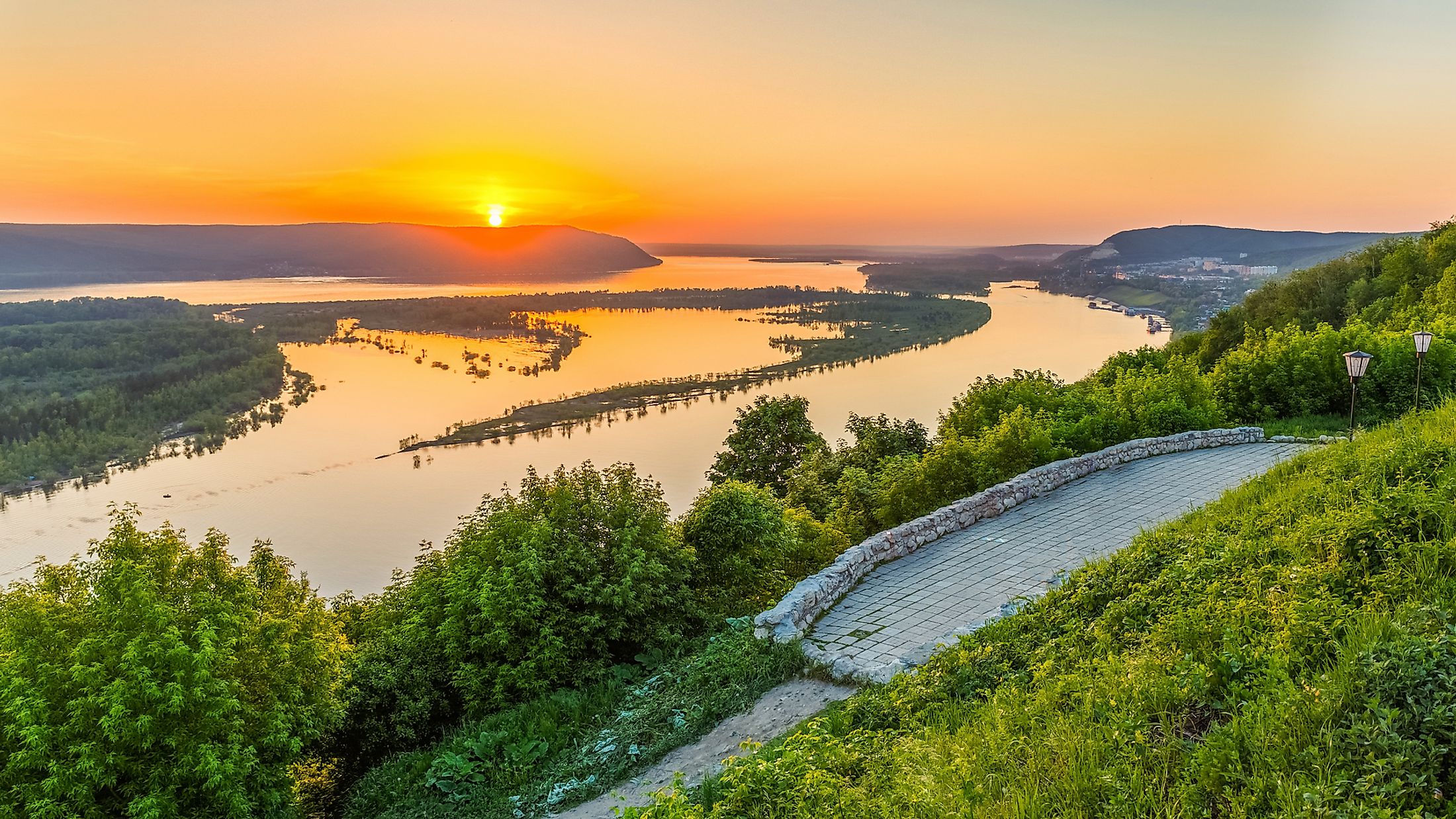
The Volga River is the longest in Europe and western Russia’s principal waterway. It covers much of the Volga region and stretches 3,530 kilometers from its source in the Valdai Hills to the Caspian Sea, the world’s largest inland water body. The Volga River Basin covers almost two-fifth of European Russia and hosts about half of Russia’s population. The river flows entirely through Russia, including four of the countries ten largest cities. Its historic, cultural, and economic importance makes it one of the world’s greatest rivers. Historically, the Volga River was the meeting point of the Eurasian Civilization. It also hosts some of the world’s largest reservoirs and a major source of livelihood to millions of people directly and indirectly.
Contents:
Description

The Volga River is the world’s 18th longest and Europe’s longest river, covering a distance of about 3,530 kilometers from its source to the mouth in the Caspian Sea. It is the longest river flowing into the Caspian Sea, the world’s largest closed basin. Its source, the Valdai Hills in Tver Oblast, is located at an altitude of 228 meters above sea level, and the Caspian Sea is located at an elevation of 28 meters below sea level.
The Volga River is also Europe’s largest river by drainage basin and discharge. Its drainage basin, located almost entirely in Russia, stretches 1.36 million square kilometers (the world’s 15th largest drainage basin), covering most parts of European Russia and hosting the bulk of the country’s population. The drainage basin is divided into four geographic zones; marshy forest, forest-steppe, steppe, and semi-desert lowlands.
The Volga discharges an average of 8,060 cubic meters of water per second, about 250 cubic kilometers per year. However, the river has a maximum discharge of 48,500 cubic meters of water per second. Volga’s important tributaries include the Oka, Sura, Kama, and Veltuga. The Volga River delta stretches 160 kilometers and comprises about 500 small rivers, making it Europe’s largest estuary.
River Course

The course of the mighty Volga River is divided into four sections. The section between its source and the confluence with Oka is called the Upper Volga. The Middle Volga begins from the confluence with Oka to confluence with the Kama, while the rest of the length forms the Lower Volga. The Volga River originates from the Valdai Hills as a small stream and only becomes a true river after it being joined by several of its tributaries. From Valdai, the river flows east past a group of small lakes and towns, including Lake Sterzh. It then turns southeast and runs through a trench and past Rzhev before turning northwestwards. Shortly after, Volga receives inflow from Tversta and Vazuza Rivers at Tver. From Tver, it continuous its northwestward flow through Rybinsk Reservoir, which also receives water from other rivers like Sheksna and Mologa.

From Rybinsk, Volga changes direction to the southeast and flows to Nizhny Novgorod through a valley between the Galich-Chukhlom Lowland and Danilov Uplands on the north and Uglich Highland on the south. Within this section, Unzha, Oka, and Kostroma Rivers join the Volga. Between Oka and Kazan, the size of the river doubles, receiving inflows from Sviyaga and Sura on the right bank and Vetluga and Kerzhenets on the left bank. From Kazan, Volga flows southwards into Samara Reservoir and is joined by the Kama on the left. Here, the Volga is now a mighty river and changes direction to the southwest and flows along the Volga Hills to Volgograd. At Volgograd, Akhtuba, Volga’s principal distributary, branches on the southeast to the Caspian Sea. The main Volga proceeds to Astrakhan where Buzan, the second distributary, branches into the Volga Delta. Other branches are Old (Staraya) Volga, Kamyzyak, and Bolda.

Hydrology
The Volga River receives much of its water from snow, accounting for up to 60% of the total discharge. Rain accounts for only 10% of the river’s water, with underground sources accounting for the remaining discharge. Before the construction of reservoirs along the river, Volga’s regime was characterized by spring floods and annual fluctuations. The water level ranged from 3 to 15 meters on the Lower Volga, 12 to 14 meters on the Middle Volga, and 7 to 11 meters on the Upper Volga. The river’s average discharge also varies with location, with Tver recording 180 cubic meters per second, 1,100 cubic meters per second at Yaroslavl, and 7,715 cubic meters per second at Samara. The average annual discharge at the river’s mouth is 8,060 cubic meters per second.
Climate
The climate of the Volga River basin exhibits variation along its course from north to south. The northern reaches of the river experience a temperate climate defined by cold, snow-covered winters, and warm, humid summers. Meanwhile, the lower parts of the river basin have hot, dry summers, and cold winters. Precipitation levels gradually drop from north to south.
Aquatic Life

The Volga River Delta at the mouth of the river is a species-rich habitat harboring 430 species of flora, 127 fish species, 260 species of birds, and 850 species of aquatic invertebrates, as well as a large repertoire of insect species. Many migratory birds, such as Dalmatian pelicans, great white egrets, breed in the Volga Delta's wetlands. Fish species in the river include several kinds of sturgeons, Volga lampreys, whitefish, and herrings.
Economy

The Volga River hosts some of the world’s largest reservoirs and dams, converting the river into a chain of small lakes. The reservoirs include navigation locks and hydropower stations. The uppermost reservoir at Ivankovo covers approximately 326 square kilometers and was completed in 1937. The reservoir Uglich reservoir covers about 250 square kilometers, while the Rybinsk Reservoir stretches 4,532 square kilometers. Other reservoirs are located at Samara, Cheboksary, Volgograd, and Saratov. The Volga has eight hydroelectric power stations along its path, while the Kama, its main tributary, has three power stations.
The Volga is navigable for about 3,330 kilometers, with the over 70 navigable tributaries transporting more than half of Russia’s inland freight. Raw and construction material accounts for about four-fifths of the total freights. Other goods transported along the river include foodstuff, petroleum products, salt, and agricultural machinery. The Volga-Baltic Waterway links the Volga River to the Baltic Sea, which joins the White Sea via the White Sea-Baltic Canal. Thus, the Volga River is linked to the major European waterway system.
Threat

Although the Volga River has benefited the Russian economy for ages, the effects of indiscriminate human activity have taken their toll on the ecosystem of the river basin. The large-scale inundation of the river, facilitated by the development of dams and reservoirs along its course, has led to a lowering of the volume of waters reaching the Caspian Sea. This, combined with the high rates of pollution of river waters, has greatly dilapidated the aquatic flora and fauna of the river. Fish species like the beluga sturgeon and whitefish, which reside in the sea but migrate to the upper reaches of the Volga for spawning, are now facing obstructions to their natural migratory routes. Large-scale poaching of fish species of the river has led to the endangering the survival of these fishes. Currently, six species of sturgeons are listed as Critically Endangered, six are Vulnerable, and all but two species are in some way threatened.