How Many Types Of Precipitation Are There?
What Is Precipitation?
Precipitation is a general term used to describe water vapor that falls from an overly saturated sky to the Earth’s surface. Precipitation type can be further defined by its mechanism or phase (being solid, liquid, or a mix). This article takes a closer look at the different types of precipitation.
Types Of Mechanisms
Orographic
Orographic precipitation, also known as relief rainfall, occurs when air is pushed up the side of mountains. The resulting elevation gain cools off the air temperature, leading to condensation and precipitation. The side of the mountain with the most wind is more humid than the opposite side.
Cyclonic
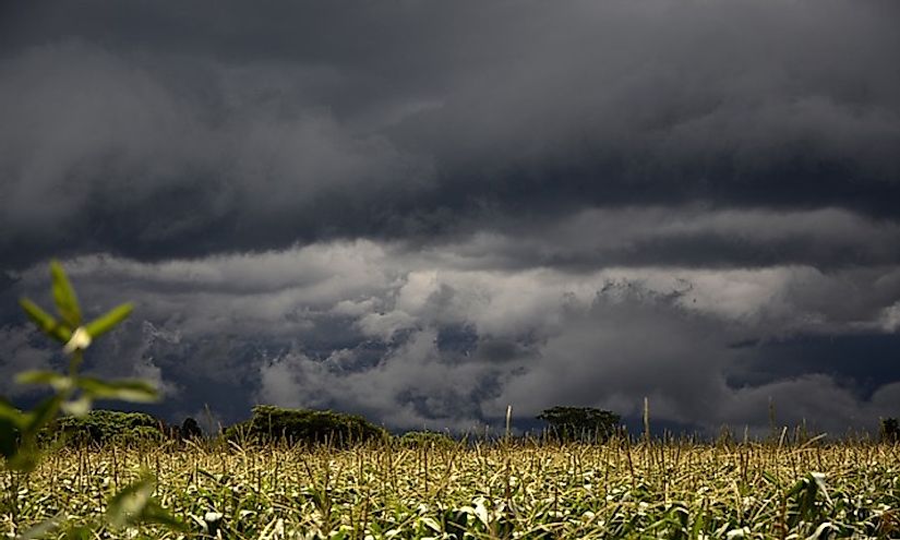
Cyclonic precipitation, also known as frontal precipitation, occurs when very warm air (usually tropical) makes contact with cool air. Nimbostratus clouds form from this contact and result in precipitation. This mechanism can occur as either a warm front, when warm air rises over cool air and creates light rain, or a cold front, when cool air moves a warm air mass and creates intense rain.
Convection
Convection precipitation is the term to describe what happens when the Earth’s surface becomes warmer than the moist air surrounding it. Condensation forms as a result, taking the shape of cumulonimbus and cumulus congestus clouds. The precipitation that falls changes in intensity over a short period of time; it is most common in tropical areas.
Phases Of Precipitation
Precipitation falls in a range of phases from liquid to solid and sometimes a mix of the two. Below is a look at each type, moving from liquid to solid form.
Drizzle
Drizzle is a very light form of precipitation with droplets that measure approximately .02 inches in diameter. Often times, drizzle evaporates before reaching the ground. The droplets that do land on the ground accumulate to less than .03 inches on average.
Rain
Rain falls in larger droplets than drizzle, around .2 inches in diameter, and reaches the ground at a rate of about 20 miles per hour. It is one of the principal pieces of the water cycle and contributes the majority of the freshwater supply on Earth. It can occur as a result of any of the aforementioned mechanisms.
Fog Condensation
Fog is made of tiny, yet visible, low-lying water droplets that are suspended in the air. It is formed when there is a 4° fahrenheit difference between the air temperature and the dew point, which is the temperature at which water vapor condenses. Fog collects on surrounding plants and buildings, falling off onto the ground below.
Freezing Drizzle
Freezing drizzle falls just like drizzle, however, it freezes upon impact at ground level. It occurs at temperatures between 32° fahrenheit (freezing) and 12° fahrenheit. It can be dangerous for humans as it creates a thin layer of ice over roads and walkways.
Freezing Rain
Similar to freezing drizzle, freezing rain is rain that falls in freezing temperatures. These large water droplets freeze upon hitting the ground or near-ground surfaces, creating a thick ice cap over everything. Freezing rain is particularly dangerous for road travel and due to the weight of its glaze, also breaks tree branches and downs power lines.
Rain and Snow Mixed
Rain and snow mixed, sometimes referred to as snain, is a mixture of rain and partly melted snow. It occurs when the precipitation falls from freezing temperatures at high elevations to above freezing temperatures at lower elevations. The snowflakes merge together in the warmer air, creating a soft and clear precipitation.
Sunshower
A sunshower occurs in an area with little to no cloud coverage while the sun is shining. Generally, this precipitation has been blown in from a rainstorm located at a distance, although sunshowers can also happen from the presence of rainclouds if the sun is low enough in the sky to shine through. Because of the sunlight, rainbows often appear during sunshowers.
Snow
Snow consists of frozen, crystalline water that falls from clouds and accumulates on the ground. The snowflakes are formed when supercooled water droplets (water that remains liquid in freezing temperatures) in clouds gather around a shared nucleus, which could be dust, clay, or some other solid particle. Upon making contact with the nucleus, the supercooled water freezes into a snow crystal. When the freezing air becomes saturated, snowfall occurs. Snow accumulates on the ground, forming snowpacks. In regions with year-round freezing temperatures, these snowpacks may form into glaciers. In other regions with warmer seasons, snowpacks melt into nearby rivers, lakes, and groundwater supplies.
Snow Grains
Snow grains are a solid, frozen form of precipitation. These tiny, white grains are usually long and flat in shape. Snow grains typically fall in small amounts from stratus clouds and fog.
Sleet
Sleet, also known as ice pellets, are small balls of ice. Sleet forms when a layer of warmer air, between 5,000 and 10,000 feet above the ground, is trapped between two freezing layers of air. The ice pellets are formed as snowflakes fall from the upper, freezing layer of air, melting on their way through the warmer air, and then refreezing as sleet in the lower, freezing layer of air.
Hail
Hail is similar to sleet, although much larger in size (between .2 inches and 6 inches in diameter). Hail usually occurs during thunderstorms, when strong wind moves upward, pushing large water droplets into freezing clouds. These water droplets accumulate in the cloud, freeze, and fall to the ground as large balls of ice - hail.
Snow Pellets
Snow pellets, also known as graupel, occur when snow crystals combine with supercooled water droplets. These droplets are able to retain a liquid state in temperatures well-below freezing. When the supercooled droplets make contact with snow crystals, the droplet freezes around the surface of the snow crystal. Snow pellets, once confused as soft hail, no longer hold the shape of the original snow crystal and on a significant accumulation the ground has the appearance of white, opaque ice.
Ice Crystals
Ice crystals, also known as diamond dust, refers to a frozen, ground-level cloud. This type of precipitation is interesting in that it occurs with cloudless skies overhead; meteorologists call this clear-sky precipitation. Ice crystals are most common on the polar extremes of Earth, in Antarctica and the Arctic. Diamond dust forms when moist, warm air sits above freezing ground-level air. The two layers mix, pulling the water vapor closer to the freezing temperatures near the ground. When the humidity level is high enough, the water vapor freezes and forms ice crystals.


