North Sea
The North Sea is one of the numerous seas in the Atlantic Ocean. It is part of the North-East Atlantic Region and opens into the Atlantic Ocean via the English Channel. The sea is one of the world's most utilized seas, with extensive fishing, shipping, power production, recreation, and defense. It also hosts two of the world’s largest ports (Hamburg and Rotterdam).
Where Is The North Sea?
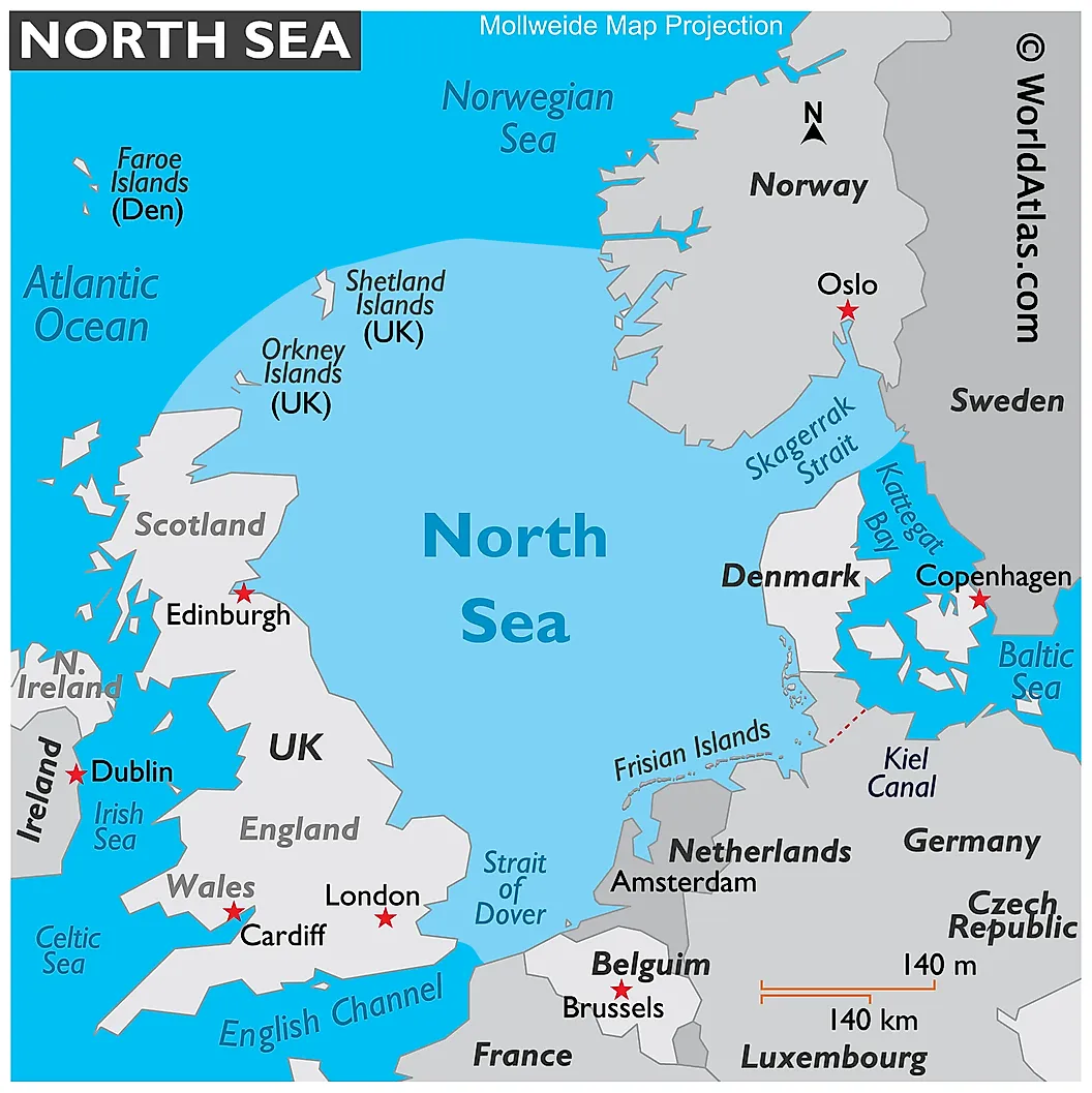
The North Sea is the Atlantic’s 13th largest sea, covering approximately 570,000 square kilometers or about 0.5% of the ocean. It is about 970 km long and 580 km wide and lies within Europe’s north-west continental shelf. The North Sea region borders some of the strongest economies in Europe. To the west of the sea is Great Britain (Scotland and England). The Northern and Central European countries such as Germany, Belgium, Denmark, the Netherlands, and Norway bound the sea to the east and west.
The North Sea connects to the Atlantic Ocean via the English Channel in the southwest and the Baltic Sea in the east via the Kattegat and Skagerrak straits. The two narrow straits Denmark from Sweden and Norway respectively. The North Sea is bordered in the north by the Shetland Islands. Some of the European countries bordering the North Sea are important sources of fresh water that flows into the North Sea, including the Rhine and Elbe.
According to the International Hydrographic Organization, the North Sea's northwestern limit is a line joining Leathercoat Point (England) and Walde Lighthouse (France). The Northwest boundary runs from Scotland’s Dunnet Head to Hoy Island’s Tor Ness, then through the island to Kame of Hoy, and finally to the Horse Island. The northern limit starts from the Fethaland Point on Shetland Island to Graveland Ness on Yell Island, thence to Gloup Ness and Spoo Ness, and finally to the coast of Norway. The Eastern boundary is on Skagerrak’s western limit and the Naze.
How Deep Is The North Sea?
The Atlantic Ocean's northern part formed through rifting during the Cretaceous and Jurassic periods, about 150 million years ago. The rifting caused the uplifting of the British isle, leading to the formation of shallow seas. Thus, the shallow seas have existed between the British Isle and the Fennoscandian Shield.
The North Sea is a shallow epicontinental sea on the northern part of the Atlantic Ocean. It has an average depth of 90 meters. However, the sea’s deepest part is the Norwegian trench, which is 20-30 kilometers wide and 725 meters deep. Although the North Sea has a surface area of about 570,000 square kilometers, its volume is only 54,000 cubic kilometers.
The seabed is composed of gravel, sandy mud, and sand and has some critical marine landscapes supporting quality marine life, including estuaries, fjords, bays, and sandbanks. The Dogger Bank, a large sandbank, rises to about 15-30 meters below the sea surface and provides a favorable fishing location on the Sea. Other shallow areas within the North Sea are Fisher Bank, Cleaver Bank, and Noordhinder Bank.
Islands Of The North Sea

Numerous islands and islets are scattered across the North Sea. These islands are of varying sizes, with some inhabited and others serving as resort and tourist destinations. Most of the sizeable islands (at least 20 sq. km.) are within the Norwegian territory.
The largest island in the North Sea is Shetland’s Mainland, covering 969 square kilometers. It is Scotland’s third-largest island and the British isle’s fifth-largest island. Mainland Island has a population of about 19,000 people.
Orkney’s Mainland Island, also known as Pomona and Hrossey, is the second-largest island in the North Sea, covering 523 square miles. The island is densely populated with 32.8 people per square kilometers and an overall population of about 17,000 people. The island serves as the main air and ferry connection on Orkney.
Norwegian Stord Island covers an area of 241 square kilometers. It is separated from Tysnesøy, the North Sea’s 5th largest island, by the langenuen strait. Most parts of Stord Island, especially the central parts, are mountainous. Thus, the majority of the population lives along the coast. Tysnesøy Island covers an area of approximately 198 square kilometers and has a population of about 2,580 people. Yell Island of Shetland is the fourth-largest island in the North Sea, with a total area of 212 square kilometers and has a population of about 1,000 people. Other islands include Karmøy, Sotra, Bømlo, Texel, Rømø, and Unst
The Climate Of The North Sea
The North Sea is located within the temperate latitudes. The westerly air circulation and the oceanic water that flows into the Atlantic Ocean strongly influences the region’s climate. The large-scale westerly winds contain a low-pressure system.
The North Sea experiences an oceanic temperate maritime climate, characterized by slightly high temperatures. Winters are long but cool while summers are short and mild. In summers, the average temperature is 17 degrees Fahrenheit, while in winter the temperature falls to 6 degrees Fahrenheit. Winter months experience frequent storms and gales.
Brief History

The North Sea was initially known as the Septentrionalis Oceanus (Northern Ocean). Later, it was known by several other names, including the German Sea, German Ocean, Germanic Sea, and Frisian Sea. However, the usage of these names became rare in the late 19th century.
The North Sea was an important waterway and facilitated commerce and conquests. The first marine traffic was by the Roman Empire in 12 BCE. The Empire conquered the region's southern areas and established trade across the English Channel and the North Sea. The Romans established ports and bays in Britain to facilitate shipping and trade. In 410, the Romans abandoned Britain, opening a window for the German's migration across the Sea.
In 793, the Viking Age kicked off with an attack on Lindisfarne. The Vikings dominated the North Sea for the next 250 years, establishing colonies and outposts throughout the Sea’s coast. The Dutch Golden Age began in the 17th century, with the harvesting of whales, cod, and herrings reaching their peaks during this period. The Dutch challenged the English over the Seas by establishing important colonies and a powerful navy over the sea. The rivalry resulted in several Anglo-Dutch Wars. In 1688, Prince William took over the throne. Shortly after, power shifted from Amsterdam to London and the British dominated the North Sea up to the 20th century.
Although the North Sea has benefitted the communities living in and around it, It has also caused pain and considerable loss. In 1953, Scotland, Belgium, England, and the Netherlands experienced one of the worst sea floods in history. A severe windstorm and spring tides over the North Sea resulted in a storm tide, causing the sea to flood up to about 5.6 meters above sea level. The water overwhelmed the marine defenses and caused considerable flooding, resulting in over 2,500 deaths. The Netherlands suffered the most damage, with 1,836 deaths and extensive damage to its farmland.

Human Settlements Along The North Sea
The North Sea has some large islands that are home to thousands of people. However, some of the islands are protected areas because of their importance in preserving marine life. The Shetland Islands have a total population of about 23,000 people, while some 22,000 people live on the Orkney Islands. Some islands forming the Hordaland island group also have some settlements, with the total population ranging between 9,000 and 11,000. Besides the islands, there is also a sizeable population along the coastal and water catchment areas, especially where the rivers discharge into the North Sea. The North Sea’s islands, coastal, and catchment areas are home to over 185 million people.
Marine Life And The Protected Areas
The North Sea supports a wide range of marine life, including fish, birds, mammals, and flora. The Sea is home to over 230 fish species, including whiting, cod, plaice, haddock, saithe, sole, and herrings. There are also several shark species in the North Sea, including some of the most feared sharks. Some of the North Sea shark species are kitefin shark, porbeagle, great white shark, blue shark, hound shark, basking shark, and school shark.

The North Sea also provides a perfect breeding location for various bird species, with millions of species using the sea for breeding. Some of the common bird species are Atlantic puffins, northern fulmars, seaducks, and terns. Mammals include walrus, common seals, whales, and dolphins.
The high population along the North Sea has affected wildlife's welfare through pollution, overfishing, and overhunting. The population of some plant and animal species has greatly declined, including gray whales and pelicans. Because of such decline and destruction, the OSPAR Convention was instituted to help preserve the North Sea wildlife. All the countries bordering the sea are signatories to the MARPOL 73/78 Accords, which requires them to prevent their ships from polluting the sea. Besides the accord, there are also nature reserves and protected areas, such as Wadden Sea National Parks, Farne Islands, Fowlsheugh, and Ythan Estuary that provide a haven for wildlife.
Economy

The North Sea has supported the economies of the neighboring countries for decades. It is Europe’s main fishing area, accounting for 5% of the international catch. Over 3.5 million tons of fish are caught annually, with trawling as the main fishing method.
Besides fishing, the North Sea is a major tourist destination. The coastal waters and beaches are major tourist destinations, with several coasts and islands developed for tourists. Some tourist towns such as St. Andrew, Bridlington, Robin Hood’s Bay, and Scarborough have been built along the coast.

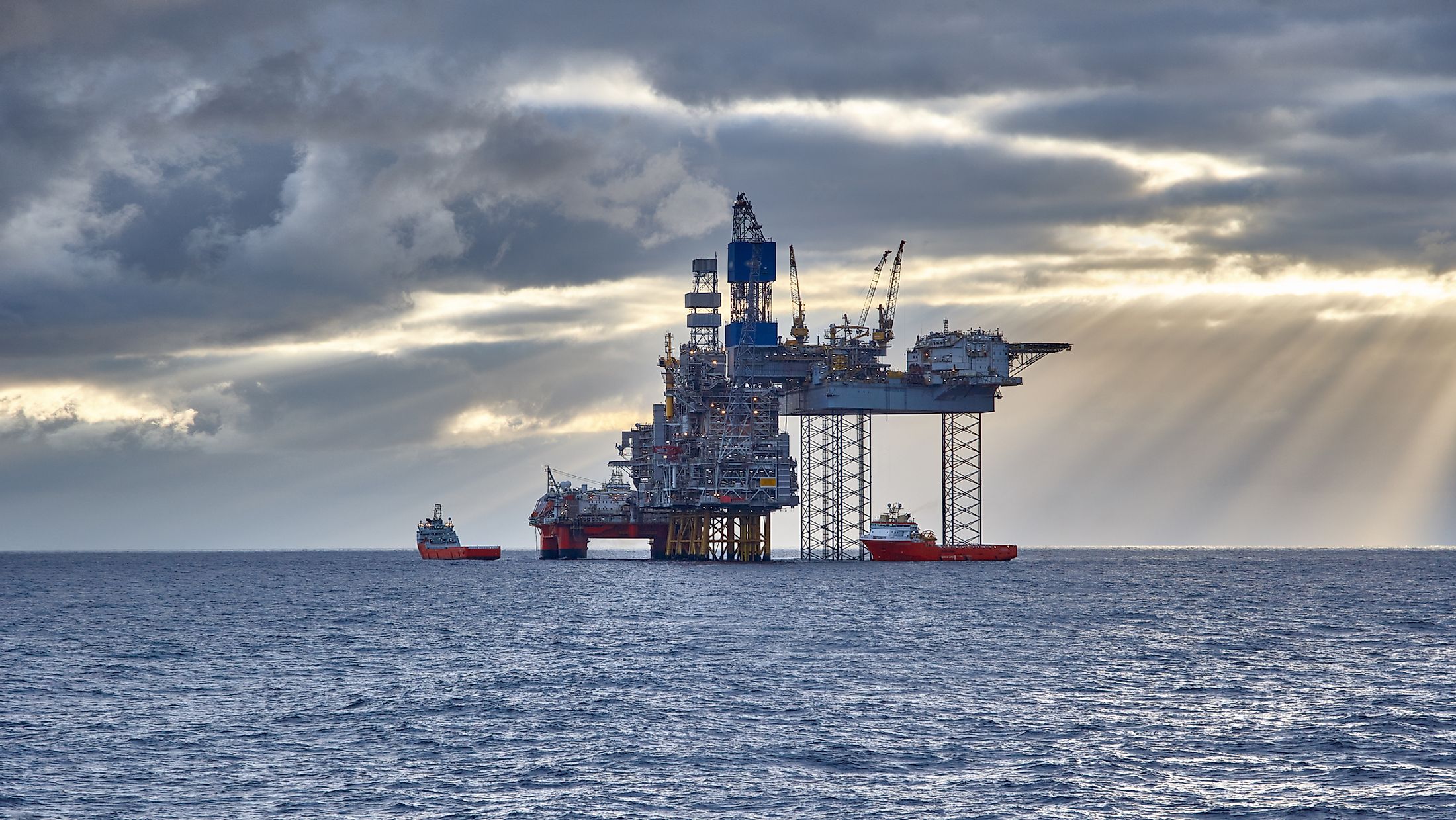
The North Sea region has up to 184 offshore oil rigs, the world’s highest. Oil was discovered in the North Sea in 1859. Offshore drilling began in 1966. The quality of oil, the sea’s proximity to main oil markets (Western Europe), and the political instability have made the North Sea a significant player in the oil industry.


