
Circles Of Latitude And Longitude
Latitudes and Longitudes are angular measurements that give a location on the earth’s surface a unique geographical identification. Latitudes are the progressive angular measurements north or south of the equator are the imaginary lines running from east to west on the Earth’s surface. While Longitudes are the measurements east or west of the Prime Meridian and run from the north pole to the south pole. Latitudes are parallel while Longitudes are convergent. This positioning method comprises of a coordinate system in degrees (°) with the Equator and Prime Meridian being the lines that denote 0°. With the Equator as the reference point, the North Pole lies at 90°N and the South Pole lies at 90°S. Likewise, the furthest point eastwards from the Prime Meridian is expressed as 180°E and the furthest point westward is expressed as 180°W.
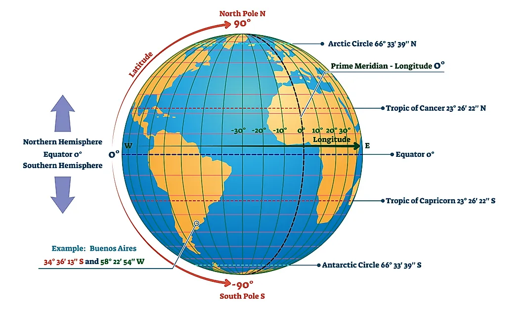
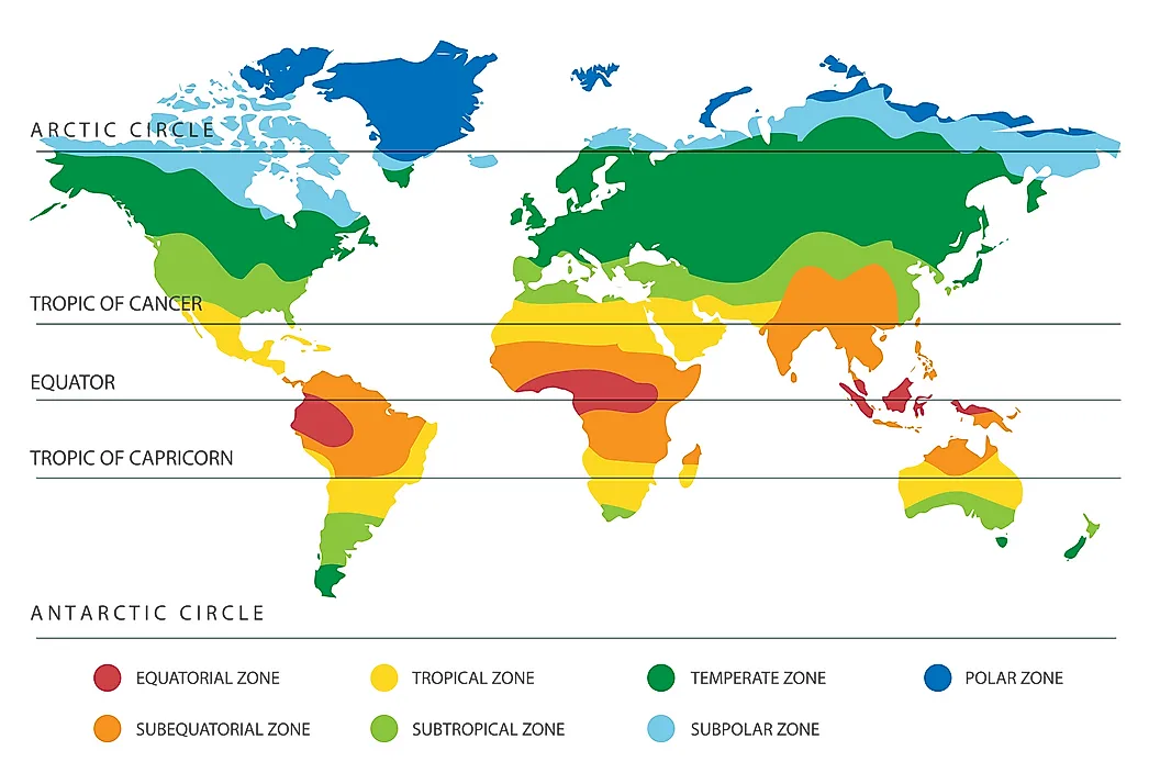
Circles of Latitude are imaginary east to west circles that connect all places with the same latitude. The reference plane for all Circles of Latitude is the Equatorial Circle of Latitude that bisects the Earth. All Circles of Latitude are parallel to the Equator and perpendicular to all Longitudes at the intersection points. Parallels get smaller towards the poles than closer to the Equatorial Plane. Unlike latitudes that have the Equator as the central Latitude, the Prime Meridian has been set as the reference point of meridians over the course of history. Circles of Latitude are called parallels while half of a longitudinal circle is called a Meridian. Meridians are important for setting time zones. There are five main parallels that are useful to explain the correlation between the Earth, the Sun, and climate. As such, these five main parallels also mark the five geographical zones. These are:
• Arctic Circle: Is the boundary of the North Frigid Zone to the north.
• Tropic of Cancer: Encloses the North Temperate Zone with the Arctic Circle.
• The Equator: Divides the earth in North and Southern Hemispheres . The are around the Equator is referred to as the Tropics and is limited northward by the Tropic of Cancer and southward by the Tropic of Capricorn.
• Tropic of Capricorn: Encloses the South Temperate Zone with the Antarctic Circle.
• Antarctic Circle: Is the boundary of the South Frigid Zone to the south.

Arctic Circle
The Arctic Circle parallel that is currently positioned at 66° 33’ 46” in the Northern Hemisphere ( or 66.5628°). The position of the Arctic Circle fluctuates by about 49 ft each year due to the Earth’s axial tilt that is determined by tidal forces resulting from the pull of the moon on the Earth’s waters. The fluctuation of the Arctic Circle has been found to be at a rate of 2° every 40,000 years. The region north of the Arctic Circle called the North Frigid Zone is characterized by extremely cold temperatures and ice. During the winter, the region experiences 24 hours of darkness in a day and 24 hours of sunlight in a day during the summers.
Antarctic Circle
This parallel of latitude is currently at 66° 33′ 46″ south of the Equator (or -66.5628°). Like the Arctic, the position of the Antarctic Circles is not fixed, as their exact location depends on the Earth's axial tilt, which fluctuates within a margin of 2° over a 40,000 year period, mainly due to tidal forces resulting from the orbit of the Moon.
The Tropic of Cancer
Tropic of Cancer is a Circle of Latitude currently positioned at 23°26’14” north of the Equator (or 23.4372°). Another reference for the Tropic of Cancer is the Northern Tropic. The Northern Tropic is the parallel at which the Summer (or Nothern or June) Solstice occurs when once a year the sun appears directly overhead the most northerly parallel. This event happens in the month of June.
The Tropic of Capricorn
Tropic of Capricorn is another Circle of Latitude currently positioned at 23°26’14” south of the Equator (or -23.4372°). The Southern Tropic is another reference for the Tropic of Capricorn. The Tropic of Capricorn is the parallel at which the Winter (or Southern or December) Solstice occurs when once a year the sun appears directly overhead the most southerly parallel. This event happens in the month of December. These two parallels enclose the area of the Earth known as The Tropics characterized by warm to hot weather and lush vegetation. Similar to the Arctic Circle, the Tropics of Cancer and Capricorn also fluctuate depending on the Earth’s axial tilt.
The Equator
The Equator is the parallel line located at 0°00’00”. It is identified as the latitude that falls at the point that is equidistant from the North Pole and the South Pole. The Equator’s covers a distance on the Earth’s surface approximately 24,901 miles long. The sun is perpendicular to the Equator twice a year in March and September. This event is called the Equinox. Areas on the Earth’s surface that fall on the Equator’s path are characterized by almost constant lengths of day and night. Likewise, the Equator fluctuates and is identified as the plane that is perpendicular to the Earth’s rotational axis.
Prime Meridian

The Prime Meridian is the meridian defined as 0°00’00” longitude. It is the longitudinal meridian of reference. Unlike the Equator’s position that is determined by the Earth’s rotational axis, the position of the Prime Meridian has been defined arbitrarily over the years as Greenwich in the United Kingdom. The Prime Meridian divides the earth into two hemispheres, the Western Hemisphere to the west and the Eastern Hemisphere to the east.


