Which Countries Have Coastlines On The Arabian Sea?
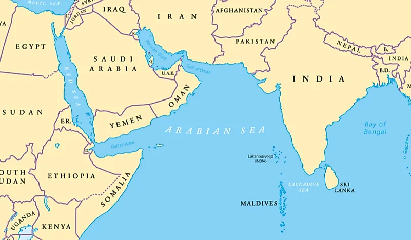
The Arabian Sea is a sea that is part of the northern Indian Ocean and is located between the Indian subcontinent and the Arabian Peninsula. It occupies an area of approximately 1,491,000 sq mi, has a maximum width of roughly 1,500 mi, and a maximum depth of about 15,262 ft. The Arabian Sea has two crucial branches, the Red Sea and the Gulf of Aden, and the biggest river that flows into it is the Indus River. The sea is bounded by India to the east, the Somali Sea to the southwest, the Laccadive Sea to the southeast, the Arabian Peninsula, Guardafui Channel, and Gulf of Aden to the west, and Iran and Pakistan to the north. The Arabian Sea has been an important marine trade route since the third or second millennium BCE, and some of the biggest cities situated along its coast include Colachel, Mumbai, Karwar, Gwadar, Mundra, Muscat, Panjim, and Vasco.
Coastlines
India
India is the largest and most populous country with a coastline on the Arabian Sea. India occupies a significant part of the Arabian Sea's eastern shoreline, which stretches from Sadashivgad, India, through the Maldives archipelago and western parts of the Laccadive, to Ras Hafun, Somalia. Some of India's main seaports on the Arabian Sea include Kochi, New Mangalore, Mormugao, Nhava Sheva, Mumbai, and Okha. Jawaharlal Nehru Port in Mumbai is India's largest container port, as well as the biggest seaport on the Arabian Sea.
Pakistan
Pakistan is the second-largest country with a coastline on the Arabian Sea. Pakistan has 650 mi of coastline along the Gulf of Oman and the Arabian Sea. The Port of Karachi is Pakistan's largest and busiest seaport situated on the Arabian Sea. Also located on the coast of the Arabian Sea, Pakistan's Gwadar Port is a deep seaport located near the mouth of the Persian Gulf, about 47 mi from the Pakistan-Iran border.
Other Countries
Other nations with coastlines along the Arabian Sea include the Maldives, Oman, Yemen, and Somalia. The Arabian Sea forms a part of Yemen's northern border, and the Maldives, which is the smallest state in South Asia, is an archipelago located in the Arabian Sea. Somalia is situated on the southwestern coast of the Arabian Sea, and the largest port in Oman, the Port of Salalah, serves as a hub for international naval task forces that fight piracy.
Islands in the Arabian Sea
There are numerous islands in the Arabian Sea, the most notable of which include Astola Island (Pakistan), Masirah (Oman), Socotra (Yemen), and Lakshadweep (India). Lakshadweep, previously referred to as Aminidivi, Minicoy, and Laccadive Islands, is an archipelago located about 270 mi from the southwestern coast of India. The islands of Lakshadweep form India's smallest union territory, which occupies an area of 12 sq mi. Astola Island, also referred to as Jezira Haft Talar, is an uninhabited island situated in the northernmost part of the Arabian Sea, in the territorial waters of Pakistan. The island of Masirah is located off the eastern coast of Oman, while the island of Socotra is situated 240 mi from the Arabian Peninsula and 150 mi from the Horn of Africa.