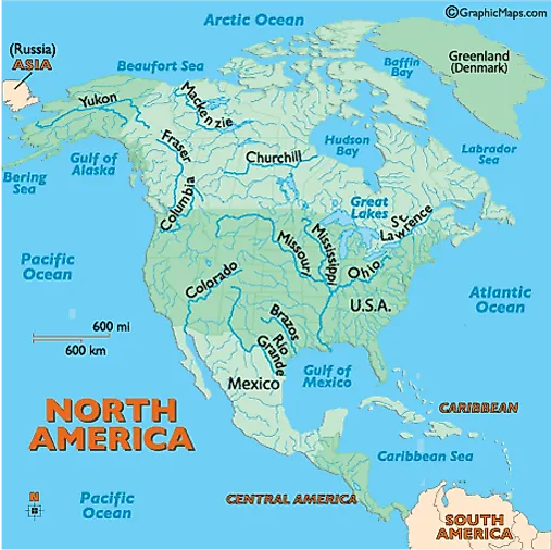
Rivers in North America - North American Rivers, Major Rivers in Canada Us Mexico - Worldatlas.com
Ohio:
Formed by the confluence of the Allegheny and Monongahela rivers in Pittsburgh, Pennsylvania, the Ohio flows generally southwest. It forms the natural borders of Ohio and West Virginia, Ohio and Kentucky, as well as parts of the borders of Indiana, Illinois and Kentucky. It empties into the Mississippi River at the Illinois border and is (975 miles) (1,569 km) long.
Rio Grande:
It is one of the longest rivers in North America at (1,885 miles) (3,034 km). It begins in the San Juan Mountains of southern Colorado, then flows south through New Mexico. It forms the natural border between Texas and the country of Mexico as it flows southeast to the Gulf of Mexico. In Mexico it is known as Rio Bravo del Norte. Used for drinking water by both countries, the river is becoming more polluted as population centers that dot the river grow in size, and then dump sewage and pesticides into the water.
St. Lawrence:
This river flows northeast out of Lake Ontario and on into the Gulf of St. Lawrence. It's (760 miles) (1,225 km) in length and permits the passage of deep-water ships between the Atlantic Ocean and the Great Lakes. It includes a series of man-made canals, locks and dams, and is considered one of the most vital shipping routes on the planet. Additional details on the St. Lawrence River and the Great Lakes.
Yukon:
It begins in the southwestern edge of the Yukon Territory of Canada, and then flows northwest across the border into Alaska. This massive river continues southwest across central Alaska, ending at the Bering Sea. Even at a length of (1,265 miles) (2.035 km), most of it is navigable, however, it remains frozen from October through mid-June.