The Panama Canal
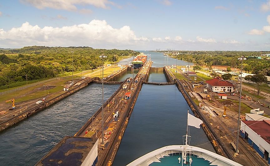
The Panama Canal connects the Atlantic and Pacific Oceans via a 48-mile long man-made waterway. The canal cuts through the Isthmus of Panama and has 3 different sets of locks. Two locks are located at each end to lift boats into Gatun Lake. The idea for the canal began 400 years before construction when Spanish explorer Vasco Nunez de Balboa first crossed the Isthmus, reaching the Pacific Ocean via the New World. A U.S. team surveyed Panama in January of 1875 and determined that the risk and cost of a canal were too great. A private French company decided to take on the challenge and began construction on December 30th, 1879. Overcome by flooding, landslides, yellow fever, dysentery, and the Civil War, the French company pulled out in December of 1888, faced with financial ruin. The United States, under the direction of President Theodore Roosevelt, took over the project 13 years later.
History of the Panama Canal
Construction and Expansion
Panama was in a civil war with Colombia when the US became involved. The American government supported Panama’s efforts for freedom and recognized the country’s independence on November 4, 1903. The two countries signed a treaty shortly after which gave canal building rights to the US. US crews began excavation in November of 1904 and soon after, the first workers fell sick with Yellow Fever. Colonel Gorgas pushed to increase investments in sanitation efforts. Two years after extensive sewage infrastructure, building fumigation, and mosquito net installation, mosquito borne illnesses were nearly eradicated. By this time however, over 5,500 workers had died. The construction required the excavation of over 200,000,000 cubic yards of material and, to achieve this, the government sent steam shovels, rock crushers, cement mixers, pneumatic drills, and an upgraded railway system. On October 10th, 1913, then-President Woodrow Wilson sent the order to destroy the Gamboa Dike. The explosion flooded the Culebra Cut and effectively joined the Atlantic and Pacific Oceans. The team completed construction in 1914 at a cost of $375,000,000 (equivalent to $8,600,000,000 today). This was the biggest engineering project in US history. In 2006, the Panama Canal saw the addition of a third set of locks. They are larger than the original thereby allowing bigger ships to pass. This addition has increased traffic through the canal.
Purpose and Significance
Prior to the Panama Canal, the trade route from New York to San Francisco sent ships around the southern tip of South America and took 2 months to complete. The canal has helped facilitate global trade by reducing transit times and costs. Today, merchants travel 8,000 miles less and have cut time to 30 days.
Territorial Disputes
The Panama Canal Zone, which included five-mile radius, eventually caused conflict between the US and Panama because it completely cut Panama in half. Originally, the US occupied and controlled the zone, even prohibiting the Panama flag. Panamanians began political demonstrations to protest in 1962 and two years later they began rioting. The countries began extensive negotiations and signed a treaty on October 1st, 1979. The treaty placed the area under joint rule and in 1999, the US relinquished all power to Panama.
Environmental Problems
The major environmental problems are deforestation due to informal agricultural practices and water loss due to billions of gallons of freshwater poured into the oceans daily. Both of these conditions lead to reduced biodiversity and environmentalists are concerned. The threat to biodiversity is also a threat to tourism in the area.
The Legacy of the Panama Canal
The Panama Canal is one of the world’s great engineering feats. The loss of life during construction was unfathomable and the environmental risks are just being realized today. Despite its obstacles, the canal has brought cultures and goods closer together.
The Panama Canal, A Maritime Link Between The Pacific And Atlantic Worlds
| The Panama Canal | Quick Facts |
|---|---|
| Length | 48 miles |
| Number of Lock Lanes | 3 |
| Location | Isthmus Of Panama |
| Construction Era | 1904 to 1914 |
| Governance and Oversight | Panama Canal Authority |