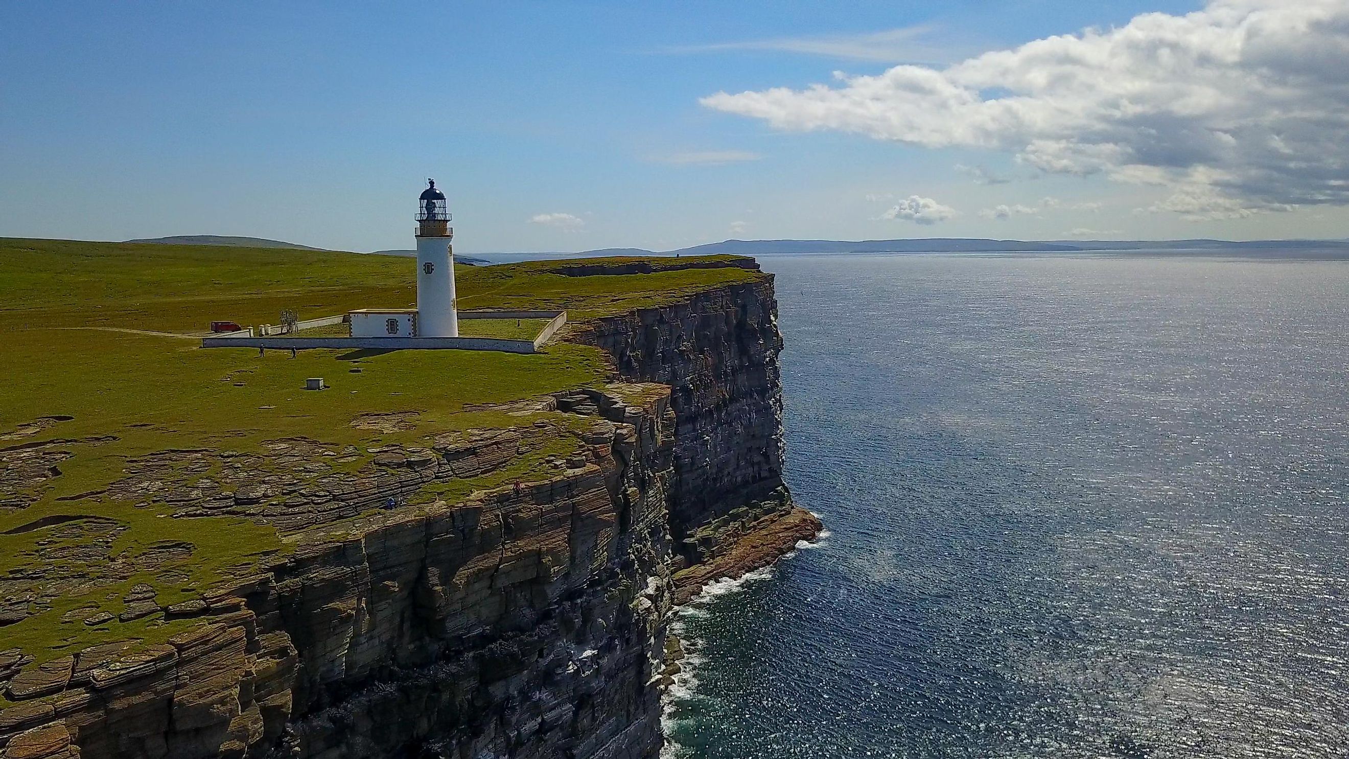
Orkney Islands
The British Isles is an island group comprising four major islands and thousands of other smaller islands. Great Britain is part of the British Isles, consisting of Scotland, England, and Wales. Off mainland Scotland’s north coast is a pair of archipelagos known as the Northern Isles.
The Northern Isle archipelagos consist of two island groups: Shetland and Orkney Islands. The Orkney Archipelago is the smaller of the two Northern Isles. It comprises over 70 islands and islets, of which only 20 are inhabited by the 22,000 people living on the archipelago.
Contents:
Where Are The Orkney Islands?

The Orkney Islands are located approximately 16 km north of mainland Scotland, across the Pentland Firth strait, where the Atlantic Ocean meets the North Sea. They are separated from the Shetland Islands by Fair Isle Channel. The archipelago lies to the south of Shetland Islands, with the Fair Isle Channel separating the two island groups. To the east of the archipelago, across the North Sea, is Norway.
Geography

Orkney is approximately 80 km long (from northeast to southwest) and 47 km wide (from west to east). It spans 975 km2 in the North Atlantic Ocean, of which Mainland, the archipelago’s largest island, takes up more than half. The total coastline of the 70 Orkney Islands is approximately 950 km.
The Orkney Islands were formed by the glacial erosion of limestone, sandstone, and igneous rocks underlying the islands into low-lying hills covered by ice deposits. Thus, the islands are mostly low-lying, with raised sandstone hills characterizing the Mainland, Hoy, and Rousey. Ward Hill, located in Hoy, is the archipelago’s highest point, rising 481 m above sea level.
Islands

The Orkney Islands can be divided into three distinct regions: Mainland, North Isles, and South Isles. Mainland, also known as Pomona or Hrossey, is Orkney’s largest island, spanning 523 km2. It derived its name from an Old Norse word, Meginland. The island was also referred to as Horse Island (Hrossey). Mainland Island is divided into two parts, East and West Mainland, by an imaginary line running between the Scapa Flow water body and Kirkwall. Kirkwall, located between the two regions, is the archipelago’s capital. West Mainland is the larger region and has nine parishes, while East Mainland has four parishes including St Ola which holds Kirkwall. About 75% of Orkney’s population live on Mainland.
The North Isles is an island group located to the north of Mainland Island. It comprises several islands with sizable land areas, connected to the Mainland by ferry service. Some of these islands are North Ronaldsay, Sanday, Westray, Papa Westray, Egilsay, Rousay, and Gairsay. The islands are rich in ancient monuments, including old-towered church ruins, standing stones, and Cubbie Roo’s castle. Some islands have a small population, including 550 people in Westray and five people in Auskerry.
The South Isles, on Mainland’s south, surround the Scapa Flow. Hoy is the group’s largest island and Orkney’s second-largest island after Mainland, covering about 134 km2. Another important feature of this island is the Old Man of Hoy, one of the United Kingdom’s tallest sea stacks at 137 meters. Flotta Island, linked to Hoy via ferry service, has a large oil terminal, while South Walls is known for the Hackness Martello Tower and Battery, built to protect British ships during the Napoleonic Wars. Other South Isles islands are Burray, Calf of Flotta, Fara, Copinsay, and Lamb Holm.
Climate
The Orkney region experiences a steady cool temperate climate due to the influence from the Gulf Stream. The annual average temperature is 4 °C (39 °F) in winter and 12 °C (54 °F) in summer. The winter season lasts from December to March, with January as the coldest month. Spring begins in April and lasts till mid-June. Summers are mild, with a record high of 25 °C (78 °F) experienced in July.
The region receives an average annual rainfall of between 850 mm and 940 mm. Fogs are common during mid-autumn and summer, and strong gales are experienced at least four times annually. One of the archipelago’s fascinations is the nightless summer, with the sun rising at 4:00 AM and setting at 10:30 PM on the longest day of the year. During winter’s shortest day, the sun rises at 9:00 AM and sets at 3:15 PM.
Brief History

Orkney may have been inhabited as early as 6820 BCE, particularly by tribes during the Mesolithic period. Knap of Howar on Papa Westray Island is considered the first permanent settlement in the region, dating back to the Neolithic period, 3500 BCE. Skara Brae, a Neolithic settlement that has been exceptionally well preserved, was inhabited from around 3100 BCE. Numerous other structures, including standing stones and passage tombs, were constructed during the pre-historic period and can still be viewed today.
During the Iron Age, inhabitants of the island traded with the Romans, and later the Gaels began significantly influencing the culture of the island. Between the late 8th century and early 9th century, Norwegian settlers trooped to Shetland and Orkney Islands. Vikings used the islands to pirate and rob Norway and Mainland Scotland. In 875, Harald Fairhair, a Norwegian king, annexed both Orkney and Shetland and later handed over the Northern Isles to his relative Rognvald Eysteinsson as an earldom. It was during Norse rule that the islands shifted from Pagan traditions to practicing Christianity, but little is known about how that change occurred.
In 1468, Christian I of Norway pledged the Northern Isles as security against his daughter Margaret’s dowry payment. While betrothed to James III of Scotland, Margaret died, and the money was never paid. Thus, the Kingdom of Scotland absorbed Orkney and Shetland. A Royal Navy base was located at Scapa Flow in the Orkney Islands, and it played a significant role in both World War I and II.
Wildlife

Orkney has abundant wildlife with both endemic and introduced species. Some of the common species are common and gray seals and plenty of seabirds. The seabirds include kittiwakes, puffins, great skuas, and black guillemots. Otters, dolphins, and whales are common in coastal areas, while Orkney vole and North Ronaldsay sheep roam the inland areas.
The coastal areas are dotted with colorful flowers of different species, including sea squill, sea aster, bell flower, common sea lavender, common heather, and Scottish primrose. The Happy Valley forest near Stenness on Mainland hosts many trees, but much ok the Orkneys are void of trees due to the strong gales the islands experience. Orkney has six Special Areas of Conservation and 13 Special Protection Areas.
Economy

Orkney has fertile soil, with farms taking up much of the land. Agriculture is the archipelago’s largest economic sector, accounting for over 25% of the workforce. Most agricultural lands (90%) are used for livestock grazing. Traditional exports from the island include beef, fish, cheese, whiskey, and seafood.
Tourism is one of the fastest-growing sectors on the islands. According to a 2020 report, tourist spending in 2019 increased by £17.6 million from £49 million in 2017. The main attraction is the “Heart of Neolithic Orkney" and the Ring of Brodgar stone circle. The islands also host several festivals, including the Saint Magnus International Arts Festival, a folk festival, and the Orkney International Science Festival.