Where is Outagamie County, Wisconsin?
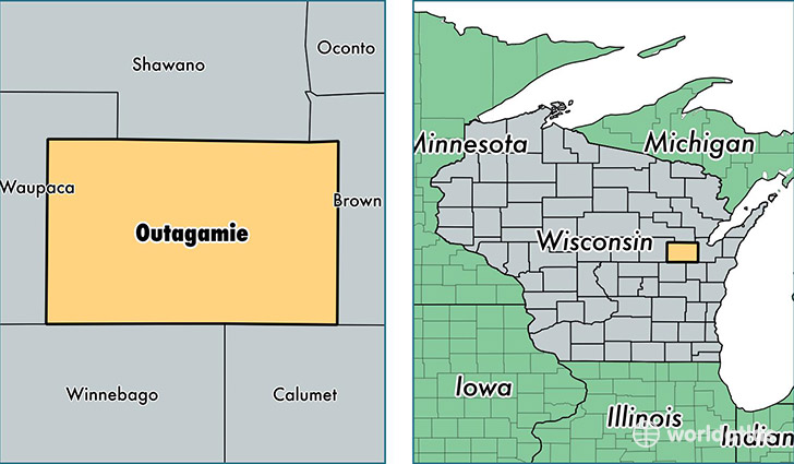
Outagamie County is a county equivalent area found in Wisconsin, USA. The county government of Outagamie is found in the county seat of Appleton.
With a total 1,669.53 sq. km of land and water area, Outagamie County, Wisconsin is the 1591st largest county equivalent area in the United States. Home to 182,006 people, Outagamie County has a total 74436 households earning 58318 on average per year.
Outagamie County, Wisconsin - Quick Facts
| FIPS Code | 55087 |
| Area Codes | 920,715 |
| Time Zone | CST |
| Major Cities | Appleton (population: 118,055), Kaukauna (population: 25,417), Greenville (population: 8,682), Little Chute (population: 8,635), Hortonville (population: 8,356), Seymour (population: 7,624), Kimberly (population: 6,482), Black Creek (population: 5,056), Shiocton (population: 3,769), Combined Locks (population: 3,364) |
| Land Area | 70,273 sq miles |
| Water Area | 637 sq miles |
| Household Income | $58,318 |
| Housing Units | 74,436 |
| Median Home Value | $155,700 |
| High School Grads | 93% of population |
| Holders of Bachelors Degrees | 26% of population |
| Retail Spending | $16,710 per capita |
| Food & Accomodation Sales | $296,108 per capita |
| Universities and Colleges | Lawrence University, Empire Beauty School-Appleton |
This page was last updated on June 30, 2016.