Maps of Georgia

Located in Eurasia's Caucasus region, Georgia occupies an area of 69,700 sq. km (26,900 sq mi). As observed on the physical map of Georgia above, it is a very mountainous country, with the rugged Caucasus Mountains stretching across the northern third, and the Lesser Caucasus Mountains dominating the central and southern landscape.The country's highest point, (100% within its borders) is Mt. Kazbek, rising to 16,558 ft. (5,047 m).Mt. Shkhara, is a few meters higher, and its southern slopes front Georgia, but it's mostly located in Russia, just to the southeast of Mt. Elbrus. It rises to 16,627 ft. (5,068m).Europe's highest point, (Mt. Elbrus) is located just over Georgia's northern border, and reaches 18,841 ft. (5,633m).All three peaks have been marked on the map.
The Kolkhida Lowlands front the Black Sea in the west, and numerous small rivers drain the area. Georgia has around 25,000 rivers that either drain into the Black Sea or the Caspian Sea (after cross Azerbaijan). The most significant rivers include the Kura and Rioni.
Georgia has a 310 km long coastline on the Black Sea to the west. The lowest point in Georgia is the Black Sea at 0 m.
Regions of Georgia Map

Georgia is divided into 9 regions (mkharebi, singular - mkhare), 1 city (kalaki) and 2 autonomous republics (avtomnoy respubliki, singular - avtom respublika). In alphabetical order, the regions are: Guria, Imereti, Kakheti, Kvemo Kartli, Mtskheta-Mtianeti, Racha-Lechkhumi and Kvemo Svaneti, Samegrelo-Zemo Svaneti, Samtskhe-Javakheti and Shida Kartli. Tbilisi is a city and Abkhazia or Ap'khazet'is Avtonomiuri Respublika (Sokhumi) and Adjara or Acharis Avtonomiuri Respublika (Bat'umi) are the two autonomous republics. Georgia is also subdivided into 76 municipalities – 12 self-governing cities (including the city of Tbilisi) and 64 communities.
Located along the banks of Kura River, Tbilisi is the capital and the largest city of Georgia. It is the chief cultural, educational, industrial and economic center of Georgia.
[note - the breakaway region of South Ossetia consists of the northern part of Shida Kartli, eastern slivers of the Imereti region and Racha-Lechkhumi and Kvemo Svaneti, and part of western Mtskheta-Mtianeti].
Where is Georgia?

Georgia is a Transcaucasian country, situated at the dividing line of the continents of Asia and Europe. It is located in the far south eastern region of the European continent. Georgia is positioned both in the Northern and Eastern hemispheres of the Earth. It is bordered by 4 countries: by Russia in the north and northeast; by Azerbaijan in the east and southeast; and by Armenia and Turkey in the south. Georgia is also bounded by the Black Sea in the west.
Georgia Bordering Countries: Turkey, Russia, Armenia, Azerbaijan.
Regional Maps: Map of Europe
Outline Map of Georgia

The above blank map represents Georgia, a Transcaucassian country strategically located at the dividing line of Western Asia and Eastern Europe. The above map can be downloaded, printed and used for educational purposes like map-pointing activities and coloring.

The above map represents Georgia, a Transcaucassian country.
Key Facts
| Legal Name | Georgia |
|---|---|
| Flag |
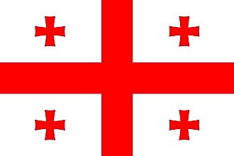
|
| Capital City | Tbilisi |
| 41 41 N, 44 50 E | |
| Total Area | 69,700.00 km2 |
| Land Area | 69,700.00 km2 |
| Water Area | N/A |
| Population | 3,720,382 |
| Largest City |
Tbilisi (1,082,245) |
| Currency | Laris (GEL) |
| GDP | $17.74 Billion |
| GDP Per Capita | $4,769.19 |
This page was last updated on February 24, 2021