The Five Regions Of Brazil
- Geopolitically, Brazil is divided into five regions or macroregions. These regions have been defined by the Instituto Brasileiro de Geografia e Estatística.
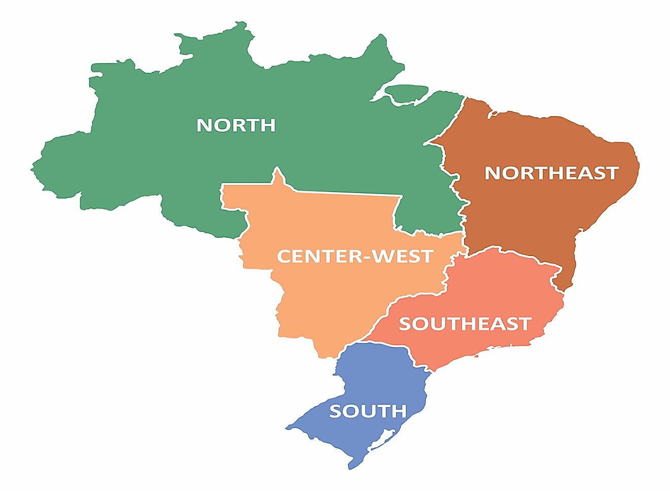
- The five regions are North, Northeast, Central-West, South, and Southeast.
- The North Region is the largest region in Brazil, accounting for 45.27% of the country's total area. However, despite being the largest in area, it ranks fourth in terms of population.
- The South Region of Brazil is made up of three states: Rio Grande do Sul, Santa Catarina, and Paraná. The region covers an area of 576,409.6 square km, making it the smallest region in the country.
- The Central-West Region of Brazil includes three states: Mato Grosso do Sul, Mato Grosso and Goiás.
Geopolitically, Brazil is divided into five regions or macroregions. These regions have been defined by the Instituto Brasileiro de Geografia e Estatística: North, Northeast, Central-West, South, and Southeast. While officially recognized, the division of Brazil into five regions is not based on geographic, cultural, and economic factors, and has no political impact. Instead, the regions are primarily for statistical purposes, and for the organization and distribution of government funding. The five regions of Brazil are described below.
5. North
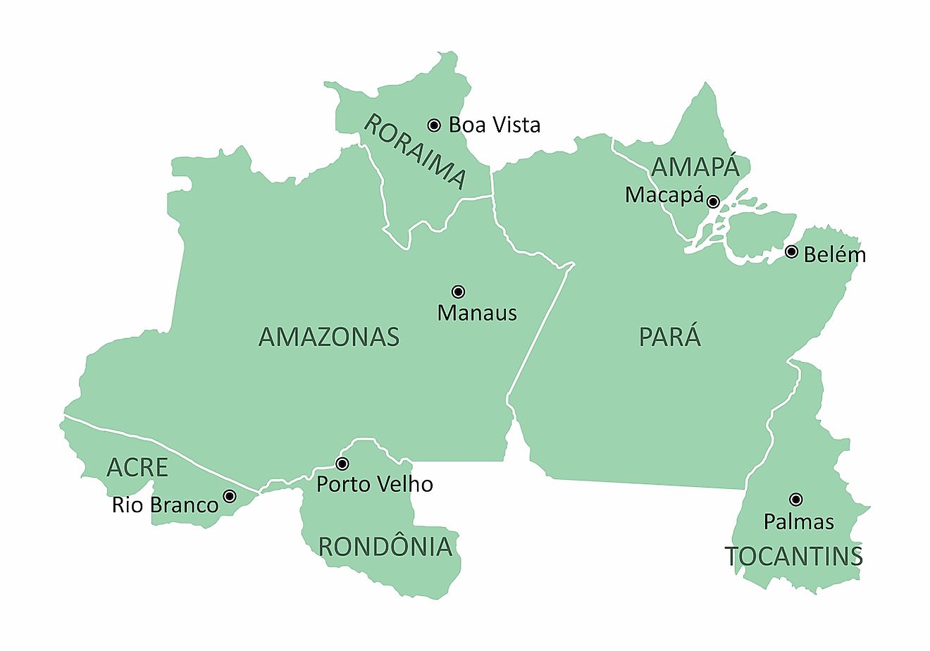
The North Region is the largest region in Brazil, accounting for 45.27% of the country's total area. However, despite being the largest in area, it ranks fourth in terms of population. The North Region includes the following states: Amazonas, Tocantins, Pará, Acre, Amapá, Roraima, and Rondônia. The region covers a total area of 3,853,676.9 square km, had a population of 17,707,783 in 2016, and a population density of 4.6 persons per square km. The population of the North Region is low given that large parts of it are covered by the Amazon Rainforest, which is one of the world’s most biodiverse areas and includes roughly 40,000 species of plants, 2.5 million insect species, 3,000 fish species, and hundreds of species of other fauna. The North Region ranks fourth in Brazil in terms of GDP per capita, and mineral extraction and forestry are the main economic activities.
4. Northeast Region
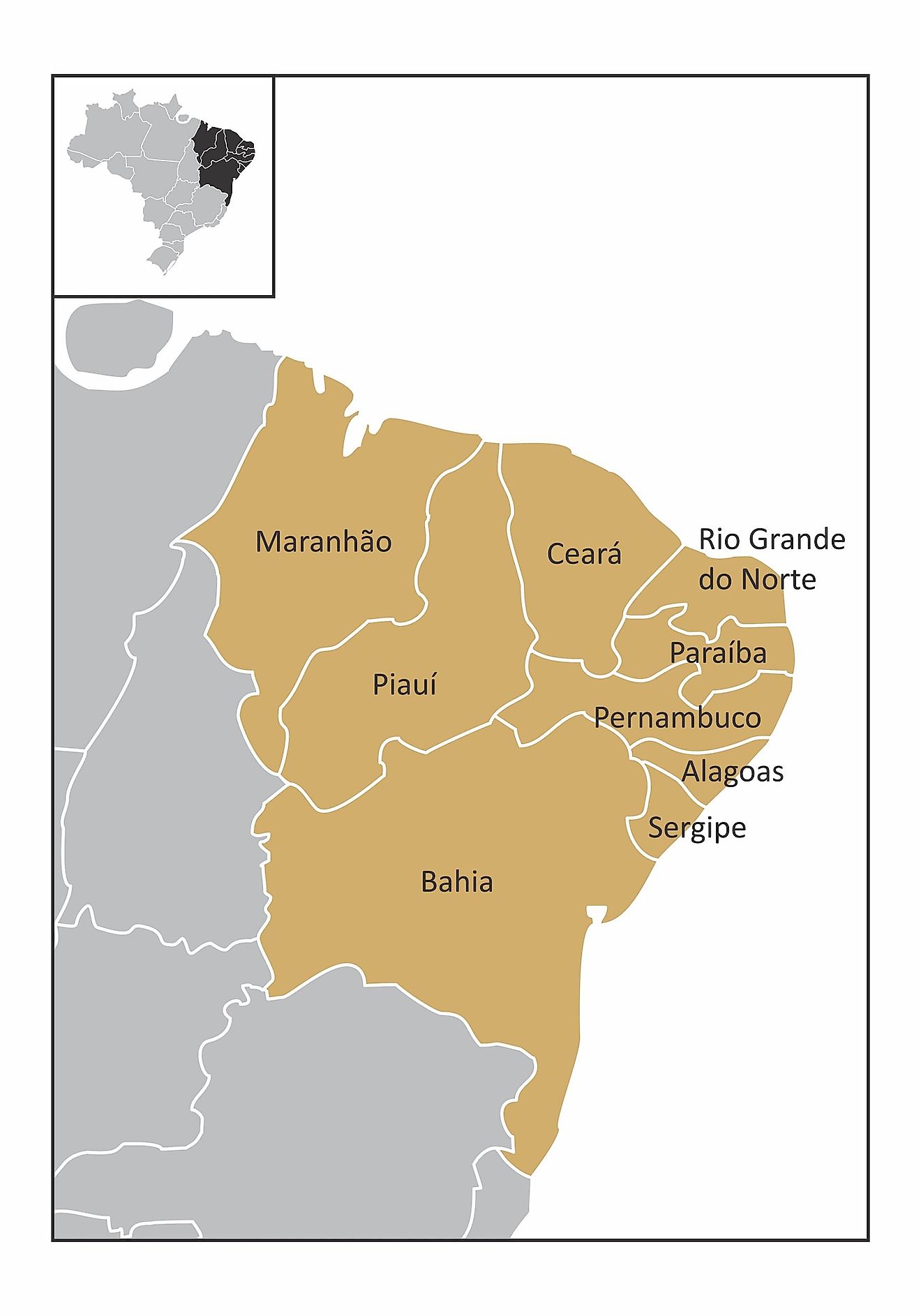
The Northeast Region of Brazil is made up of nine states: Maranhão, Rio Grande do Norte, Paraíba, Sergipe, Bahia, Alagoas, Pernambuco, Ceará, and Piauí. The scenic Fernando de Noronha archipelago also belongs to the region. The Northeast Region is associated with rich history and culture, and was the first region in Brazil to be discovered and colonized by Europeans. The region covers an area of 1,558,196 square km, has a population of about 56.9 million, and has a population density of 34 persons per square km. It is the third largest region in the country in terms of area, ranks second in population, and has the lowest GDP per capita. The landscape of the Northeast Region varies widely, and includes a long Atlantic coastline to the northeast and southeast, while the western and northwestern parts belong to the Amazon basin. The Espinhaço highlands are located towards the south, and the drainage basin of the São Francisco River is also located in the region. The river and its branches allowed Europeans to easily access and develop the interior of the Northeast Region. The region’s economy primarily depends on cocoa, cotton, and coffee production, and livestock breeding.
3. Central-West Region
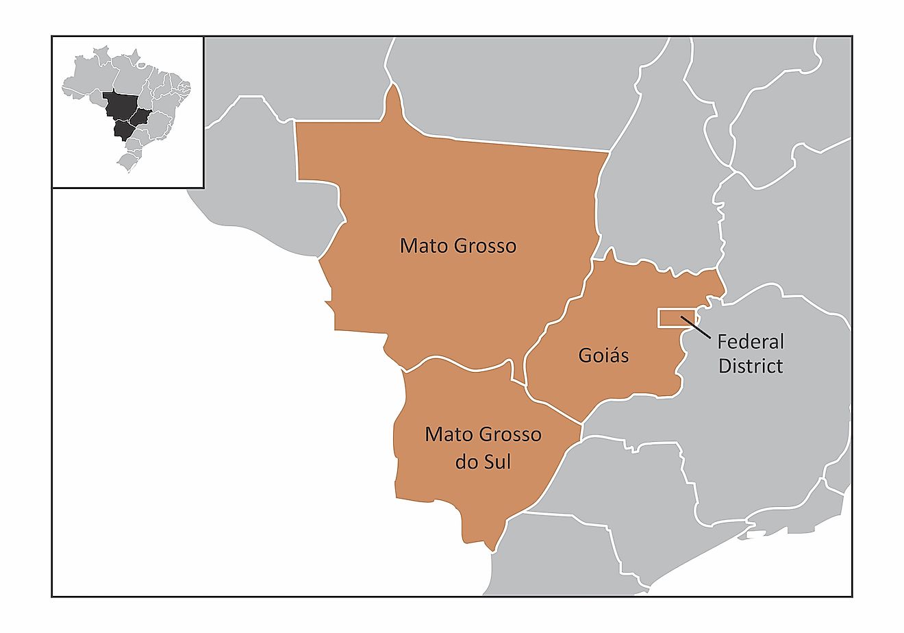
The Central-West Region of Brazil includes three states: Mato Grosso do Sul, Mato Grosso and Goiás. The Federal District, which is home to Brasília, the capital city of Brazil, is also part of the region. Located in the heart of the country, the Central-West Region covers an area of 1,612,077.2 square km, which accounts for 18.86% of Brazil's total land area. Although it is the second largest region by area, it is the least populated, with a population of around 15.6 million. It has a population density of only 10 persons per square km, which ranks as the fourth least densely populated region in Brazil. 86.3% of the population lives in urban areas. The main ecosystems in the region include the Amazon Rainforest, the Cerrado, and the Pantanal. The Central-West Region is currently experiencing rapid development, which was partly the result of shifting Brazil's national capital from Rio de Janeiro to Brasília in the 1960s. The per capita GDP of the Central-West Region is the second highest, and its economy is mainly dependent on livestock breeding, mining, and tourism.
2. Southeast Region
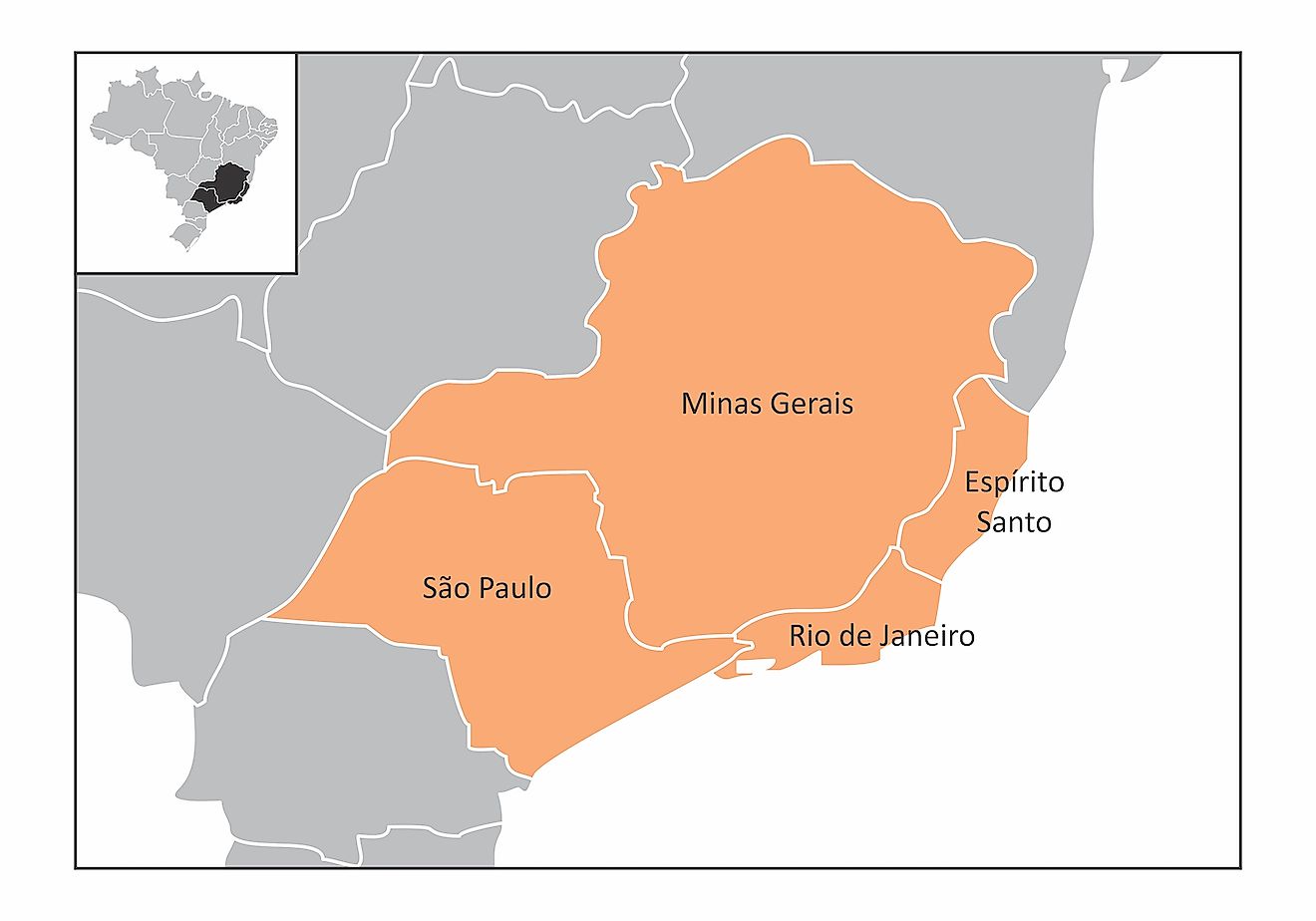
The Southeast Region is the richest region in Brazil. The region is made up of four states: Rio de Janeiro, São Paulo, Espírito Santo, and Minas Gerais. The Southeast Region encompasses an area of 924,511.3 square km and has a population of 86.3 million people, which ranks as the fourth largest region by area and the most populated. It is also the most densely populated region, with a population density of 87 individuals per square km. The region contributes about one-third of the nation's total GDP, and has a highly diversified economy that is based on various industries such as machinery, services, aviation, finance, automobile, commerce, and textiles. The Southeast Region stretches from the Atlantic Coast to the interior and features coastal plains, interior plains, high mountains, hills, caverns, and valleys.
1. South Region
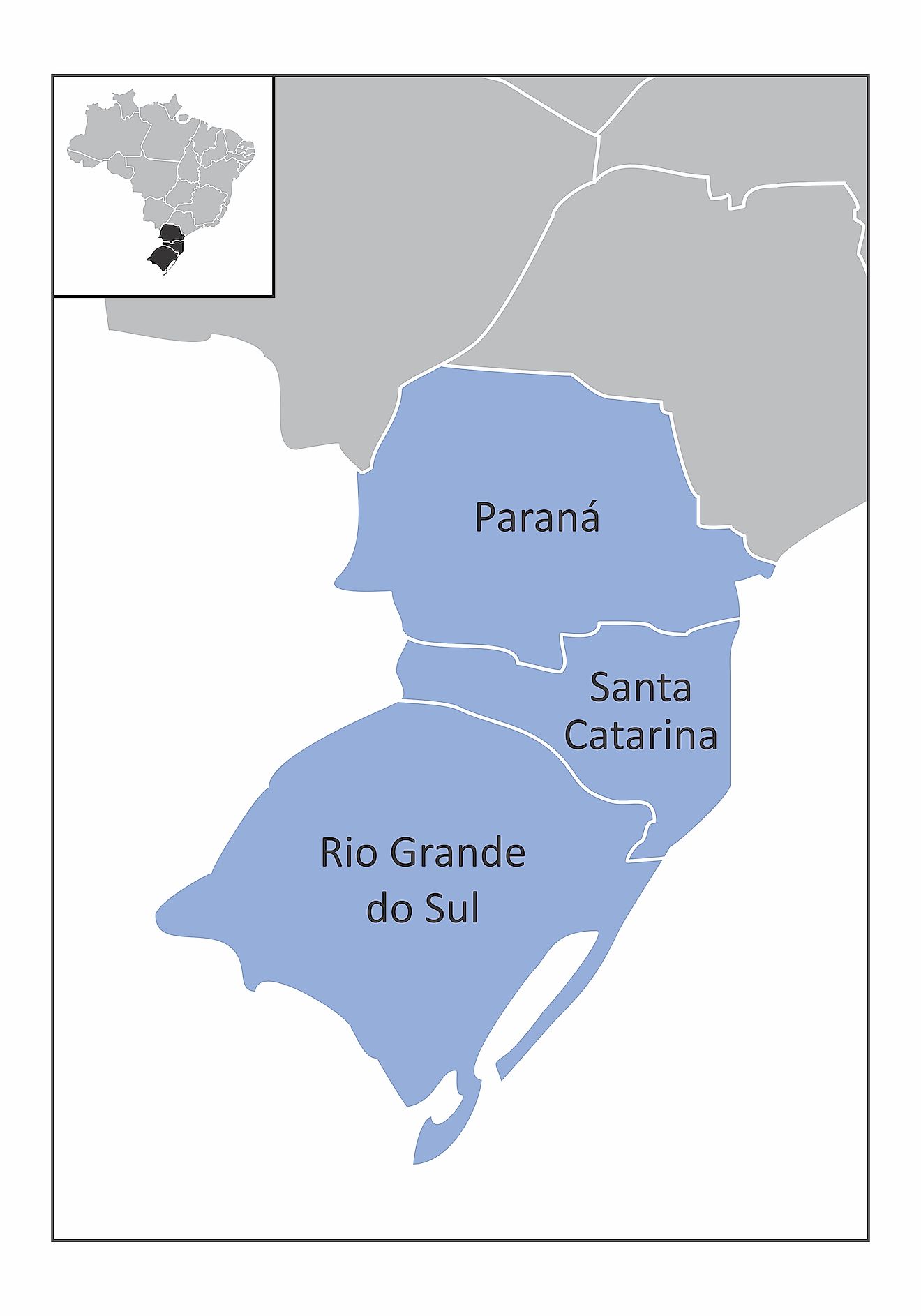
The South Region of Brazil is made up of three states: Rio Grande do Sul, Santa Catarina, and Paraná. The region covers an area of 576,409.6 square km, making it the smallest region in the country. The South Region has a population of 29.4 million people and a population density of 50 individuals per square km. It is the third most populated and second most densely populated region in Brazil. The region's total area is less than that of the Minas Gerais state in Southeast Brazil. The South Region is a cultural, economic, and tourism hub, and its GDP per capita is the second highest in the country. It has the lowest crime rate of any region, and is therefore considered the safest in the country to visit.
The Five Regions Of Brazil
| Rank | Name | Population (2016 Estimate) | Largest city | Largest Metropolitan Area | Number of States |
|---|---|---|---|---|---|
| 1 | North | 17.7 million | Manaus | Manaus metropolitan area | 7 |
| 2 | Northeast | 56.9 million | Salvador | Recife metropolitan area | 9 |
| 3 | Central-West | 15.6 million | Brasília | Brasilia Urban Metropolitan Complex | 3 + DC |
| 4 | Southeast | 86.3 million | São Paulo | São Paulo metropolitan area | 4 |
| 5 | South | 29.4 million | Curitiba | Porto Alegre metropolitan area | 3 |