The Largest Cities In Canada
In terms of land area, Canada is the second-largest country in the world. Yet, in terms of population, Canada ranks only 39th. Despite the low population density, there are still some sizeable cities spread across this friendly Northern country. Each of these acts as a magnet for various reasons, including prestigious Universities, lucrative industries, favorable geography or weather, unique cultures, and of course, almost all of the ten largest cities on this list have a crowd-drawing National Hockey League (NHL) team. Here are the 10 largest Canadian cities in terms of population:
1. Toronto - 6.255 milion

Toronto is located in Southern Ontario, on the Western shore of Lake Ontario (one of the Great Lakes). This provincial capital could be likened to the New York of Canada. It is a bustling metropolitan, a concrete jungle, and a hub for culture and business. "T-oh," "T-dot," or "Torono," as it is also called/pronounced, is home to several crowd-drawing, internationally recognized sports teams, including: the Toronto Maple Leafs (one of the NHL's Original Six teams), the Toronto Raptors (NBA), and the Toronto Blue Jays (MLB). The University of Toronto is well-regarded globally and draws students and faculty from all over. Visitors will know they have arrived at the sight of the CN Tower, which until 2007 was the tallest free-standing structure in the world (currently the 9th).
2. Montréal - 4.247 million

Bonjour! Canada's second-largest city is in the Southwest portion of the French-Canadian province of Québec, on the Northern shore of the St. Lawrence River. It is a place of unique culture, history, architecture, and some of the best poutine and bagels one could hope to find. The Montréal Canadiens (Les Canadiens de Montréal), or "The Habs," have been packing seats since 1909, which even predates the formation of the National Hockey League. Speaking of sports, Montréal was the host city for the 1976 Summer Olympics. McGill University is another revered institution for higher education, complete with a lovely and diverse campus.
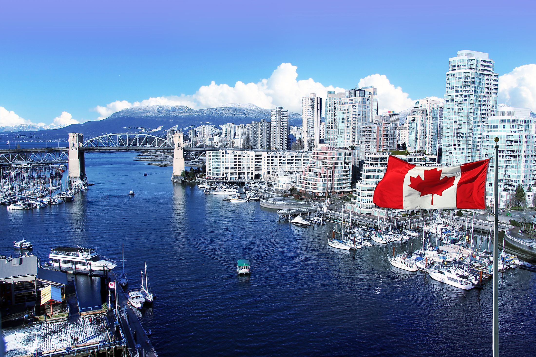
3. Vancouver - 2.606 million

Vancouver is biggest city of British Columbia, Canada's westernmost province. The city enjoys one of the most temperate climates in the nation. The surrounding waters to the West, which tease the presence of the Pacific Ocean, and the verdant, often snow-capped mountains of the North Shore further boost the natural appeal for locals and tourists alike. This close-proximity combination makes it possible to surf and ski on the same day - a great bucket-list double for any outdoor enthusiast. The go-to ski spot for Vancouverites is the nearby world-famous resort town of Whistler. This site helped Vancouver secure the 2012 Winter Olympics. Though warmer than other major Canadian cities, hockey is still weaved into the fabric of the culture. The Vancouver Canucks have as loyal a following as any NHL team, a fact which showed its full fervor during the 2011 Stanley Cup riots.
4. Calgary - 1.581 million

"Be part of the energy" is the slogan for this Rocky Mountain city in the province of Alberta. This refers to the once-booming but still fluctuating nature of the oil and gas industry that has served as the backbone of Calgary's growth over the years. More recently, "Cowtown" has diversified its economy by enthusiastically embracing the craft brewery and retail cannabis (federally legalized in 2018) markets. The city also draws large tourist crowds for the annual Calgary Stampede (i.e., "The Greatest Outdoor Show On Earth") and because of its proximity to Banff National Park, which sees upwards of four-million annual visitors. The resident NHL team, the Calgary Flames, play their home games within the Stampede grounds, at the aptly named Saddledome. The University of Calgary continues to rank in the top 10 Universities in Canada, as well as admirably on the world stage.
5. Edmonton - 1.491 million

The capital city of Alberta shares a lot in common with Calgary, its neighbor to the South. Edmonton also owes its vitality to the energy sector, and it has also welcomed the craft beer and cannabis cultures with open arms. The layout of the city is unique in that it has, in a way, two downtown cores. There is the recently revitalized Jasper Avenue and newly built Rogers Place (home of the Edmonton Oilers) on the north side of the North Saskatchewan River. There is also the Whyte Avenue and University of Alberta campus (yet another top-tier institution) on the south side of the beautiful river valley. Similar to the Calgary/Banff relationship, Edmonton acts as a base city for many visitors to the equally-stunning Jasper National Park.
6. Ottawa-Gatineau - 1.408 million

The last Canadian city to crack the one-million population barrier is the nation's capital. Ottawa, located in the province of Ontario, is the true capital, and Gatineau is another large city, just across the Ottawa River, in the neighboring province of Québec. The two cities form a functional unit with consistent ebb and flow. Together they draw politicians, students of the University of Ottawa, demonstrators, businessmen/women, and plenty of other residents/visitors to this pulsating place. There is always something going on in Ottawa, especially on Parliament Hill, where almost every major holiday and commemorative occasion sees an enthusiastic event.
7. Québec City - 0.832 million

Québec City is the capital city of the francophone province of the same name. It is approximately 250 kilometers (155 miles) Northeast of Montréal, also on the St. Lawrence River. Québec City is particularly magnetic in terms of its history and classic architecture. The castles and cobblestone streets of the fortified Old Québec (or Old Québec City) are not to be missed. This fairy tale neighborhood is a UNESCO World Heritage Site. The now-defunct Québec Nordiques were yet another NHL team synonymous with the culture. Though the team moved to Denver, Colorado, in 1995, visitors to Québec City will no doubt still see some of those red, white, and blue jerseys/hats amongst the crowds.
8. Winnipeg, Manitoba - 0.825 million

Winnipeg is the capital of the prairie province of Manitoba, which is in Central Canada. The industrial layout is dense with strip malls and burly trucks as one approaches downtown on the Trans Canada Highway. That being said, there are also many pretty parks peppered throughout the city, as well as the massive freshwater lakes of Lake Winnipeg and Lake Manitoba, located just North of the city. This opens the door to plenty of summer fun to contrast the bone-chilling winters - though there is certainly a coziness to the cold. During the frosty months, there is no shortage of hot chocolate-rich community events, including ice-skating, festivals, and of course, Winnipeg Jets NHL games.
9. Hamilton, Ontario - 0.771 million

"Steel City," as Hamilton is also known, is a mere 70-kilometers (43-miles) Southwest of Toronto, nestled on the Hamilton Harbour, which stems from Lake Ontario. Hamilton has a lot going for it to round out its steel industry image. There is McMaster University, another top-of-the-list higher education and research institution. Also stemming from the campus is the charming West End district, which leads further into the small town of Dundas. Furthermore, the Harbour, though damaged from years of industrial pollution, is still a captivating site that can be seen and felt from almost anywhere in the city. And finally, the natural beauty of the Niagara Escarpment looms large over the city, beckoning residents to its wonderful network of hiking trails, including a portion of the epic, 900-kilometer (560-mile) Bruce Trail, as well as the 100+ waterfalls that are captivating enough to rewire all inadequate connotations. It is a little-known fact that Hamilton did have an NHL team, known as the Tigers, for a brief period (1920 - 1925).
10. Kitchener-Cambridge-Waterloo - 0.571 million

The final entry on this list is an amalgamation of three nearby cities that make up the Regional Municipality of Waterloo. Kitchener, Waterloo, and Cambridge (KWC), also known as the Tri-Cities, are spread between 100 - 120 kilometers (62 - 75 miles) southwest of Toronto. This works well for the daily commuters. As the Greater Toronto Area (GTA) expands ever further in diameter, the populations of the surrounding cities grow with people looking to work in Toronto but avoiding the prohibitive cost of living. There is no NHL team, past or present, for this cluster of Southern Ontario cities, but as the population booms, who knows what the future will hold?
Though Canada is the 10th least densely populated country in the world (3.92 people per square kilometer or 10.2 people per square mile), its roughly 38,345,820 citizens still congregate in some large and appealing cities. These hubs not only bring the people together, but they do so for a variety of reasons. This gives each city a distinct sense of character, eh.
| Rank | Urban Agglomeration | Estimated Population (in thousands), 2021 |
|---|---|---|
|
1 |
Toronto |
6,255 |
|
2 |
Montréal |
4,247 |
|
3 |
Vancouver |
2,606 |
|
4 |
Calgary |
1,581 |
|
5 |
Edmonton |
1,491 |
|
6 |
Ottawa-Gatineau |
1,408 |
|
7 |
Québec |
832 |
|
8 |
Winnipeg |
825 |
|
9 |
Hamilton |
771 |
|
10 |
Kitchener-Cambrigde-Waterloo |
571 |


